Nucleated Rural Settlements
Each character area within this zone, equating to an individual settlement core, has been described and mapped separately in the Nucleated Settlement Gazetteer. As a result, this zone description will concentrate on a brief overview only.
Summary of Dominant Character
The zone represents the majority of the areas of nucleated settlement established by the time of, and mapped by, the first 6inch survey of the Barnsley area by the Ordnance Survey, published between 1851-4. Character area boundaries within this zone have been drawn to include areas developed at this time and also related peripheral areas, especially plots directly relating to residential properties, village greens, churches, former manorial sites, etc. Most of these character areas include some 20th century infill, where it has respected earlier property boundaries and scales. Where 20th century infill has introduced new plan forms and patterns within an older settlement, it has been shown on the mapping included in the gazetteer as being characteristic of a later period.
Typical buildings within these settlements include parish churches and vernacular buildings of the medieval (1066-1539) and post-medieval (1540-1749) periods; later development often includes more ‘polite’ architectural forms, related to the gentrification of some settlements by landed estates, and the construction of middle class villa housing in the 19th century, in addition to brick built terraces from the mid 19th century onwards. More recent modifications usually include examples of semi-detached and detached suburban housing, primary schools and new shop fronts.
Relationships with Adjacent Character Zones
This zone includes the historic cores of villages that are still isolated within rural countryside and those that have become absorbed within the large-scale suburbanisation of the district. In the medieval period these villages were often surrounded by land farmed in the open field system, typically enclosed in the post-medieval period in thin reverse ‘s’ shaped fields. In the east of the district these field systems have largely been subject to 20th century boundary removal and are discussed within the ‘Agglomerated Enclosure’ zone. In the west of the district however, strip patterns often survive better and these are discussed within the ‘Strip Enclosure’ zone.
Many of the settlements within this zone have been subject to expansion, in some cases leading to the historic core being completely surrounded by ‘Industrial Settlements’, ‘Planned Industrial Settlements’, ‘Late 20th Century Private Suburbs’ or other settlement zones. The ‘Industrial’ and ‘Planned Industrial’ settlements are the most common zones to be immediately associated with the historic village cores. This relationship is most apparent in the east of the district, on the Middle Coal Measures (see Figure 1), where rich coal seams were extensively mined in the 20th century, leading to the expansion of settlements in this area. An exception to this is Billingley, which has been little altered since the 18th century and probably largely retains its medieval plan form.
The Lower Coal Measures have also been subject to coal extraction, but mines in this area generally fell out of use at an earlier date than those in the east of the district, many closing before the first edition OS survey in the 1850s. The workforce at many of these early mines would often have had dual occupations (Hey 1986, 221), combining mining with farming or other industries such as woollen weaving, nail making and wire making. None of these industries had the same large-scale impact on settlement size as the later mining in the east, but where they were prevalent settlements did expand onto areas of former common, or within the historic core of the village. Thurlstone, Penistone, Cawthorne, Dodworth, High Hoyland and Pilley show utilisation of commons or greens for housing prior to the 19th century.
Settlements in the west of the district often didn’t expand significantly beyond their historic core until the mid to late 20th century when they became increasingly attractive to commuters. Suburbanisation of this group of settlements typically began as ribbon development along main roads. Most of the smaller villages in this zone have experienced continuing infilling of their historic cores and piecemeal replacement of older buildings as part of a similar trend. This pattern of suburbanisation is also true in the east of the district, but often occurs outside the historic cores - around the earlier industrial and planned industrial settlement zones.
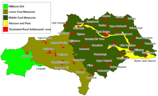
Figure 1: Distribution of the Nucleated Rural Settlements zone against the geology of Barnsley.
Based on OS mapping © Crown copyright. All rights reserved. Sheffield City Council 100018816. 2007
Several of the ‘Nucleated Rural Settlements’ within Barnsley also have an important relationship with the ‘Private Parkland’ zone. In the case of Wortley and Worsbrough, this relationship and close proximity prevented the large-scale expansion typical of many settlements in the area. These villages were maintained as fairly picturesque settlements, which could be seen from the park and hall. It was possible to restrict the expansion of these settlements, because much of the land belonged to the hall owner. At Cawthorne, where the park developed late in the history of the settlement, there were no limits on expansion to accommodate migrant workers, as was seen at many ‘closed’ estate villages (Hey 1986, 240).
Former areas of parkland at Brierley and Tankersley also impacted on the ‘Nucleated Rural Settlements’ of Grimethorpe and Tankersley. These settlements were adversely affected by the creation of the nearby parks, leading to their depopulation (Harrison & Watson 2006; Hey 1975, 111).
Inherited Character
Where later development of a settlement has included little more than the piecemeal replacement of properties within existing historic boundaries, the form of the medieval settlement often survives well. Thurlstone is a clear example of a planned medieval village that has retained its pattern of narrow plots running perpendicular to the main high street (see Figure 2). This pattern can be seen to a greater or lesser extent in a number of the historic cores within this zone.
This style of planned row village is fairly common in the north of England in the medieval period and is believed to have replaced an earlier pattern of scattered hamlets. The development of a communal open field system of farming is also believed to be contemporary with this replanning (Aston 1985, 72). As well as Thurlstone, there are good examples of ‘row’ villages at: Cawthorne, Dodworth, Silkstone, Royston, Brierley, Great and Little Houghton, Wombwell, Nether Hoyland and Monk Bretton. Other settlements in this zone show aspects of planning, but without the clear pattern of regular plots that these villages exhibit (on historic maps). There are, however, settlements within this zone that are likely to have developed from mere hamlets, which were not redesigned in the medieval period.
Aston (1985, 72) has suggested that the large number of planned villages in the north of England represents opportune development after William the Conqueror’s ‘harrying of the North’, which led to many settlements being recorded as ‘waste’ in the Domesday Book, in 1086. Other research has suggested that there is a link between replanning of settlements in the medieval period and high status landowners such as abbots and bishops (Sheppard 1974; 1976, cited in Aston 1985).
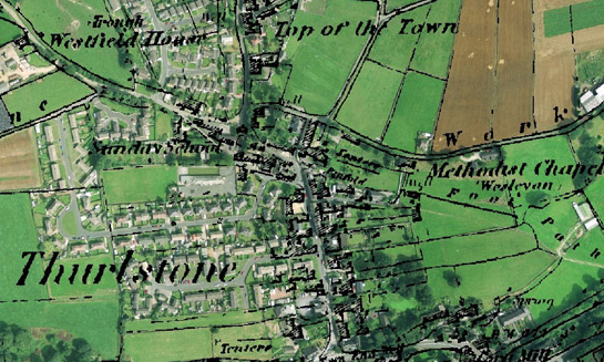
Figure 2: Thurlstone
Cities Revealed aerial photography © the GeoInformation Group, 2002 overlain with 1851 OS mapping © and database right Crown Copyright and Landmark Information Group Ltd (All rights reserved 2008) Licence numbers 000394 and TP0024
In Barnsley, both Dodworth and Monk Bretton have clear associations with high status landowners – in both cases Pontefract Priory (Monk Bretton Priory being a daughter of Pontefract) (Sykes 1993, 233-4; Hey 1986, 59). The town of Barnsley itself (described within the ‘Complex Historic Town Cores’ zone) was similarly replanned by the monks of Pontefract (Elliot 2002, 25-27).
Comparison of the best-preserved examples of planned medieval villages in this zone with data from the South Yorkshire Sites & Monuments Record (SYAS 2008) reveals that many contain known manorial sites dating to the medieval period. The legibility of these sites depends on the extent of later growth of the settlement of which they formed a part. Where later growth has been absent or limited, such sites may still show significant legibility of their medieval form.
Later Characteristics
The later development of these settlements is intimately related to the processes of industrial expansion and suburbanisation discussed above. The identification and designation of many historic cores as Conservation Areas from the 1960s onwards has helped to preserve their character. Outside of designated Conservation Areas, or where redevelopment preceded their creation, suburbanisation has frequently reduced the legibility of historic forms. A common cause of this reduction in legibility is the amalgamation of historic plots, to produce larger plots of land for the development of housing estates. Settlements within this zone that have been fairly substantially altered by modern developments include: Bolton Upon Dearne, Carlton, Darton, Higham, Lower Cudworth, Royston, Wombwell and Worsbrough. These settlements do, however, still retain earlier buildings and street patterns. Ardsley, Grimethorpe, Goldthorpe, Kexbrough, Little Houghton, Mapplewell, Monk Bretton and Pilley have also been substantially altered since the 19th century, mostly by the building of terraced and semi-detached housing for colliery workers.
Character Areas within this Zone
Map links will open in a new window.
- Ardsley Historic Core (Map)
- Barnsley Old Town (Map)
- Billingley (Map)
- Bolton Upon Dearne Historic Core (Map)
- Brierley Historic Core (Map)
- Carlecotes Village (Map)
- Carlton Historic Core (Map)
- Cawthorne Historic Core (Map)
- Darfield Historic Core (Map)
- Darton Historic Core (Map)
- Dodworth Historic Core (Map)
- Goldthorpe Historic Core (Map)
- Great Houghton Historic Core (Map)
- Grimethorpe Historic Core (Map)
- High Hoyland (Map)
- Higham Historic Core (Map)
- Howbrook (Map)
- Hoyland Swaine Historic Core (Map)
- Ingbirchworth Village (Map)
- Keresforth (Map)
- Kexbrough Historic Core (Map)
- Langsett Village (Map)
- Little Houghton (Map)
- Lower Cudworth Historic Core (Map)
- Mapplewell Historic Core (Map)
- Monk Bretton Historic Core (Map)
- Nether Hoyland Historic Core (Map)
- Penistone Historic Core (Map)
- Pilley Historic Core (Map)
- Roughbirchworth (Map)
- Royston Historic Core (Map)
- Shafton Historic Core (Map)
- Silkstone Historic Core (Map)
- Snowden Hill (Map)
- Tankersley (Map)
- Thurgoland Historic Core (Map)
- Thurlstone Historic core (Map)
- Thurnscoe Historic Core (Map)
- Upper Cudworth Historic Core (Map)
- Upper Hoyland (Map)
- Wombwell Historic Core (Map)
- Worsbrough Village (Map)
- Wortley Village (Map)
- Aston, M.
- 1985 Interpreting the Landscape: Landscape Archaeology and local History. London and New York: Routledge.
- Elliot, B.
- 2002 Glimpses of Medieval Barnsley. In: B. Elliott (ed.), Aspects of Barnsley 7. Barnsley: Wharncliffe Books, 23-38.
- Harrison, M. & Watson, M.R.
- 2006 Brererley, A History of Brierley [online]. Available from: www.brierley59.freeserve.co.uk/Brererley%20A%20%20history%20%20of%20%20%20Brierley.htm [accessed 01/05/08].
- Hey, D.
- 1975 The Parks at Tankersley and Wortley. Yorkshire Archaeological Journal, 47, 109-118.
- Hey, D.
- 1986 A Regional History of England: Yorkshire from AD 1000. London and New York: Longman.
- Roberts, B.K.
- 1996 Landscapes of Settlement; Prehistory to the Present. London: Routledge.
- SYAS
- 2008 South Yorkshire Sites and Monument Record [dynamic MS Access – GIS database] Sheffield: South Yorkshire Archaeology Service. Available by appointment with SYAS, Howden House, 1 Union Street, Sheffield, S1 2SH. Email: syorks.archservice@sheffield.gov.uk [accessed 07/05/08].
- Sykes, S.
- 1993 The Patchwork Quilt: Finding Dodworth's Medieval Landscape. In: B. Elliott (ed.), Aspects of Barnsley. Barnsley: Wharncliffe Publishing Limited, 225-247.
Bibliography
1The term nucleated settlement is used to describe a pattern of settlement “where buildings are built together in clusters (i.e. hamlets or villages)” (Roberts 1996, 24)