Post Industrial
Summary of Dominant Character
This zone is characterised by late 20th century landscapes of distribution, retail, light industry, leisure and transport. The zone has developed across a variety of former landscapes, from the later 20th century onwards, but has mainly affected former colliery sites. 51% of the zone is categorised by the project as having ‘extractive’ characteristics, generally consisting of surviving spoil heaps. However, most of these sites are undergoing rapid alteration, with landscaping and erection of large industrial and commercial sheds having taken place since 2003.

Figure 1: Current landscape types within the ‘Post Industrial’ zone, as recorded by the South Yorkshire HEC project.
Areas such as ‘Carlton Industrial Estate’ and ‘Carlton and Monkton Extractive Sites’ show a mix of modern development, along with plantation woodland and regenerative scrubland. Elsewhere, at ‘Dearne Valley Mines’, ‘Park Hill Brickworks’ and ‘North Wombwell Park’, large areas have been landscaped and set aside as public parkland, nature reserves and newly established agricultural land with very little industrial or commercial development.
This zone dominates the eastern half of Barnsley district, due to the former concentration of coal mines in this area and the more established modern transport links. East Barnsley has good links with the M1 motorway and the A1(M) and industrial and business parks have been established at major road intersections. These road junctions are built in the stark poured concrete that characterises much of the UK motorway network, and generally include earthwork embankments and cuttings to provide sloping slip-roads to join the motorway to the rest of the trunk road system, often via large elevated roundabouts. The business parks closest to the M1 (at ‘Barugh and Redbrook Business Parks’, ‘Former Darton Main’, ‘Dodworth Business Park’ and ‘Wharncliffe Silkstone Colliery’) have grown because of good transport links, but most developed on former colliery sites, some of which would still have been in operation in the late 1960s when the motorway was built.
‘Post Industrial’ developments not formerly part of a colliery site themselves are often sited close to a former colliery, such as at ‘Worsbrough Canal Basin’, which is adjacent to ‘Worsbrough Park Colliery’, or they are located in areas of early industry located along the canal and railway lines through Barnsley town.
Relationships with Adjacent Character Zones
This zone is widely distributed across the central and east of Barnsley district. The close association with former coal mines and other areas of former industrial activity means that there are also close relationships with areas of ‘Industrial Settlements’ and ‘Planned Industrial Settlements’. These settlements housed the work force at the collieries and other industrial sites and their improvement is often the driving force for the redevelopment of the former industrial sites - either to improve the quality of the landscape around the towns or to bring new employers into the area.
Inherited Character
The redevelopment of former industrial and coal mining areas is often specifically designed to remove the former character of the area, as land reclamation regimes seek to improve the landscape. However, the large scale of the spoil heaps that developed alongside these mines in the mid to late 20th century can sometimes defy removal without very substantial earth moving operations. This means that, despite considerable alteration of the land through landscaping, planting of trees and grasses, and removal of colliery buildings, many of the sites within this zone have significant historic legibility of their coal mining past.
The Lower and Middle Coal Measures are the dominant geology within the Barnsley district. These rocks hold valuable coal and clay seams that dip from the west to the east. The thickest deposits of coal run down the centre of the Coal Measures with one of the most productive seams being the Barnsley Bed. Further east the seams thin and dip further underground, until the coalfield runs beneath the Magnesian Limestone west of Doncaster (Hill 2002, 14).
By the middle of the 19th century collieries in the west of the coalfield were beginning to become exhausted and advances in technologies of transport, ventilation and pumping were beginning to make the exploitation of the deeper seams a reality (ibid 16). This led to a vast increase in mining in the district and, as technologies developed further, many of the collieries expanded to cover wide areas. The former collieries within this zone were often first worked in the mid to late 19th century but were subject to significant expansion in the mid 20th century.
The reorganisation of the coal industry in the 1970s and 80s led to many pits closing or combining with other nearby collieries and by the 1990s there were only small numbers of active pits in the district. After closure the colliery buildings were sometimes pulled down immediately but the mounds caused by the extensive dumping of spoil were left as dominant features in the landscape. A sizeable network of railways was developed within Barnsley to transport coal from the collieries. Although many of these lines were removed in the late 20th century, earthworks preserve their course and surrounding developments fit within the pattern of the former railway lines. Examples of such legibility of the earlier industrial landscape can be seen at both ‘Smithies Post Industrial’ and ‘Worsbrough Park Colliery’ character areas.
Alongside the 19th and 20th century coal mining activities in this area are remains associated with ironstone extraction around Tankersley. This area was once part of Tankersley deer park, which was enclosed in 1303-4 (Hey 1986, 81-2), but ironstone mining began within the park boundary from at least the early 18th century (old ironstone pits are marked on an estate map of 1749) (Jones 1995, 84). Spoil heaps dominate the area and survive, reused, within a golf course. There is also some legibility of the former parkland as the golf course sits within the old park walls. Ironstone from this area was sent to the Milton and Elsecar Ironworks and to the Thorncliffe Ironworks. Parts of Elsecar Ironworks survive and are described in the ‘Industrial’ zone, but Milton Ironworks closed in 1927 and the site was cleared for a public park in the 1980s.
The nature of the activities at these sites means that beyond traces of their earlier development as extractive landscapes, previous historic character is generally invisible having literally been mined away. Parts of Tankersley are an exception to this. Another exception is at ‘Bullhouse’. This area was subject to small scale coal, stone and ganister extraction from at least the mid 19th century, which led to the felling of Bullhouse Wood, but there are several surviving field boundaries along the edges of the former extractive area.
Patterns of legibility and development are more complex within the non-extractive character areas of the zone. This is particularly true of the former industrial sites along the Dearne valley, running from Old Mill down through Wombwell. This area has been heavily utilised by industrial concerns over the years, a trend that continues within this zone. Modern industrial development takes place in large mixed use industrial and business parks. Around Stairfoot and Old Mill however, earlier industrial sites have been replaced with large retail developments.
The positioning of former industrial sites will have been partially influenced by the availability of flat land along the Dearne valley but transportation links will have played a significant part in the development of the area. The Dearne and Dove Canal, which runs through this area, was fully opened in 1804, connecting with the Barnsley Canal and the Don Navigation (Glister 1995, 118). Parts of the canal system were falling out of use from the 1920s but final abandonment only came in 1961 (ibid, 120-22). Although the canal has been infilled in places, the course is often fossilised by property boundaries. Within this zone the canal can bee seen within ‘Old Mill Retail Parks’, ‘Stairfoot Post Industrial Area’, ‘Wombwell Business Parks North’, ‘Wombwell Park’, and ‘Worsbrough Canal Basin’.
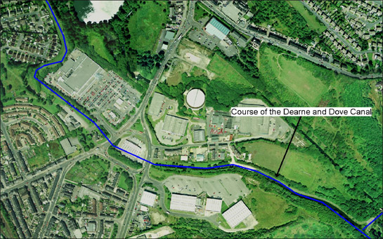
Figure 2: Former course of the Dearne and Dove Canal (in blue) as it runs through Old Mill in Barnsley, where former industrial sites have been replaced with modern retail developments.
Cities Revealed aerial photography © the GeoInformation Group, 2002
A broad selection of industries developed around the Dearne and Dove Canal in the 19th century, including lime kilns, coke ovens, saw mills, gas works, bleachworks, paperworks and glassworks.
The bleaching of cloth was closely connected with the linen industry in Barnsley. Within this zone there were bleachworks at ‘Monk Bretton Colliery’, ‘Old Mill Retail Parks’ and ‘Stairfoot Post Industrial Area’, all well positioned to take advantage of the canal. There are no visible remains of these sites. Monk Bretton Colliery expanded across Newbridge Bleachworks, completely altering the landscape; Old Mill Bleachworks was overwritten by the expansion of the adjacent paperworks in the early 20th century; Stairfoot Bleach and Dye works was demolished for warehousing in the 1970s. The later industrial sites have also been removed in recent years; Old Mill has become an area of retail developments and Monk Bretton Colliery has gradually been over built by business parks.
The area around Old Mill has quite a complex industrial history. The Dearne Paperworks developed in the mid 19th century on the site of a 14th century corn mill that had been converted into a flax spinning mill in 1802 (Umpleby 2000, 131-2). Alongside these developments was a saw mill, tannery, early gas works and a large glassworks. Within this zone there were also glassworks at Wombwell, Worsbrough Basin and Stairfoot.
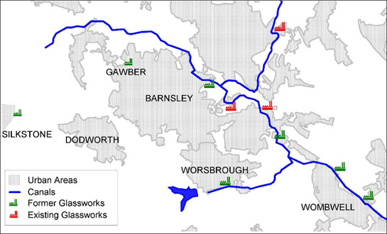
Figure 3: Former and existing glassworks in Barnsley.
Based on OS mapping © Crown copyright. All rights reserved. Sheffield City Council 100018816. 2007
The glass industry in Barnsley began in the 17th century, with glassworks developing in Silkstone and Gawber. By the 19th century there were multiple glassworks across the central portion of the district, mostly linked with the canal system (Ashurst 1992, 5). Bottle manufacture was the prime concern of many of these sites and in the late 19th century South Yorkshire had created a virtual “world-wide monopoly in bottles for aerated waters” (ibid, 3). Several of these sites still exist as glass producers and are considered within the ‘Industrial’ zone, but five sites fall within this zone. Most of these sites were replaced by commercial or light industrial units in the late 20th century, while the Dearne and Dove Glassworks at Wombwell and the Wood brothers glassworks at Worsbrough basin have been removed to develop areas of public parkland. Within all these areas it is only the course of the canal that hints at an industrial past.
Later Characteristics
As this zone is typified by much of the most recent developments to affect the Barnsley landscape it is perhaps best to consider it as a growing landscape, highly likely to expand over the next decade. During the life of the project work has been in progress at most of the colliery sites within this zone, most notably in the establishment of community woodlands and nature reserves.
Character Areas within this Zone
Map links will open in a new window.
- Barugh and Redbrook Business Parks (Map)
- Bullhouse (Map)
- Carlton and Monckton Extractive sites (Map)
- Carlton Industrial Estate (Map)
- Darton and East Gawber Collieries (Map)
- Dearne Valley Mines (Map)
- Dodworth Business Park (Map)
- Elsecar Former Industry (Map)
- Former Darton Main (Map)
- Goldthorpe and Thurnscoe Extractive Sites (Map)
- Goldthorpe Industrial Estate (Map)
- Grimethorpe and Houghton Collieries (Map)
- M1 Junctions (Map)
- Monk Bretton Colliery (Map)
- Mount Osborne Industrial Park (Map)
- North Wombwell Park (Map)
- Old Mill Retail Parks (Map)
- Park Hill Brickworks (Map)
- Platts Common Industrial Estate (Map)
- Rockingham Colliery (Map)
- Smithies Post Industrial (Map)
- Stainborough Park Mines (Map)
- Stairfoot Post Industrial Area (Map)
- Tankersley Ironstone and Coal Workings (Map)
- West Barnsley Post Industrial (Map)
- Wharncliffe Silkstone Colliery (Map)
- Wombwell Business Parks (Map)
- Woolley Colliery (Map)
- Worsbrough Canal Basin (Map)
- Worsbrough Park Colliery (Map)
Bibliography
- Ashurst, D.
- 1992 The History of South Yorkshire Glass. Sheffield: JR Collis Publications, Department of Archaeology and Prehistory.
- Fairbank, W.
- 1777 A Map of the Township of Barnsley in the Parish of Silkstone. Available from: Barnsley Archives, Ref: EM/1953.
- Hey, D.
- 1986 A Regional History of England: Yorkshire from AD 1000. London and New York: Longman.
- Hill, A.
- 2002 The South Yorkshire Coalfield: a History and Development. Stroud: Tempus Publishing Ltd.
- Gill, M.
- 2007 Mines of Coal and other Stratified Minerals in Yorkshire from 1854 [Geo-referenced Digital Database]. Available from: Northern Mines Research Society, 38 Main Street,
Sutton in Craven, KEIGHLEY, Yorkshire, BD20 7HD. - Glister, R.
- 1995 The Dearne and Dove Canal. In: B. Elliott (ed.), Aspects of Barnsley 3. Barnsley: Wharncliffe Publishing Limited, 116-132.
- Jones, M.
- 1995 Ironstone Mining at Tankersley in the Nineteenth Century for Elsecar and Milton Ironworks. In: B. Elliott (ed.), Aspects of Barnsley 3. Barnsley: Wharncliffe Publishing Limited, 80-115.