Early to Mid 20th Century Private Suburbs
Summary of Dominant Character
This zone is characterised chiefly by small areas of housing developed speculatively between 1914 and 1945, in small estates or as areas of ribbon development on the edges of existing settlements. Stylistically, developments in Barnsley during this period have much in common with areas developed in the ‘Municipal Suburbs’ and ‘Planned Industrial Settlements’ zones. These housing developments, with their geometric street patterns and spaciously arranged semi-detached housing, were heavily influenced by the garden city designs of Ebenezer Howard. Howard was working in the late 19th and early 20th century, designing satellite settlements of low density houses with associated shops and recreational facilities (Edwards 1981, 83). These designs were then adapted by Raymond Unwin and used as the basis for many contemporary municipal and private housing developments (Unwin 1994 [1909], 236).
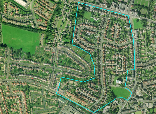
Figure 1: Part of the ‘Early 20th Century Private Suburbs’ zone at Wilthorpe in north west Barnsley, outlined in blue, surrounded by stylistically similar geometric municipal estates.
Cities Revealed aerial photography © the GeoInformation Group, 2002
In the district of Barnsley there are significantly fewer areas of privately built housing of this period than municipal housing developments. The private estates tend to be small and were not, as a rule, built to a wholesale plan but rather in phases of piecemeal development. There is often a mix of detached and semi-detached housing within these estates and some plots with very different housing styles, where individual houses have been built independently.
The areas making up this zone are on the edge of existing settlements and are generally set away from industrial landscapes. Most of the areas within this zone are built along or near to a main road (often toward Barnsley town centre) to facilitate the home owner’s journey to work. At the time when these houses were built, there were significantly fewer cars on the road, making these road side locations more desirable than they are currently.
Relationships to Adjacent Character Zones
Where early 20th century private suburbanisation has occurred on a small scale, such areas of housing have been included within other Character Zones, as infill. Some larger areas of private development have also been included within the ‘Planned Industrial Settlements’ zone as, in many cases, these private developments can be seen as part of the ongoing industrial settlement expansion. However, the early suburbanisation at the edge of Dodworth is included within this zone, despite nearby mining activity at the time of construction, as the housing is very close to the edge of Barnsley town and would have been developed as early commuter belt.
Housing within this zone tends not to be the first phase of settlement in an area, but is generally built adjoining earlier settlements. This housing is also generally not the last phase of suburbanisation, leading to early 20th century housing becoming sandwiched between bands of earlier and later suburbanisation.
Inherited Character
By area, 83% of this zone was developed directly on agricultural land on the edges of existing settlements. Field boundaries are often fossilised in the edges of these early suburbs; where the estates developed in a piecemeal fashion there tend to be further boundaries preserved within the estate. Housing within the ‘Staincross Common’ and ‘Kingstone Early Suburbanisation’ areas was built upon surveyed enclosure of former common land. The regular layout of the streets and housing plots here follow the former field pattern quite well. Much of the early suburbs at Kingstone are also surrounded by large areas of ‘Grid Iron Terraced Housing’, which itself fits within this regular pattern of fields. The more sinuous field patterns of former assarted woodlands and areas of former strip fields tend not to be preserved.
The housing within the ‘Sheffield Road Early Suburbanisation’ area preserves few field boundaries, but the housing is built along the course of the turnpiked road between Barnsley and Worsbrough Dale. The turnpike cut across the former field pattern in the area and became the course of the tram line running between Barnsley and Worsbrough.
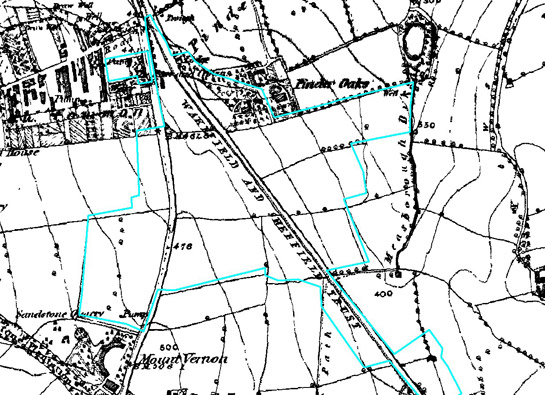
Figure 2: The Wakefield and Sheffield Trust turnpiked road cutting through the earlier field patterns. Part of the ‘Early 20th Century private Suburbs’ zone is outlined in blue.
1855 OS map © and database right Crown Copyright and Landmark Information Group Ltd (All rights reserved 2008) Licence numbers 000394 and TP0024
The tram depot of the Barnsley Tram Company, which was built in 1902 (Bayliss 1995, 68), falls within this zone. The site was later rebuilt and expanded and in 1913 the Barnsley Electric Traction Company bought its first motor bus. The last tram ran back into the depot in 1930 but the site continued as the home of the Yorkshire Traction bus company (Polding 1998, 75-77). The development of the tram route in the early 20th century was likely to have caused an explosion of speculative building along this road.
There are generally few legible early features beside road patterns and field boundaries within this zone. However, the housing at ‘Barugh Ribbon Development’ and ‘Gawber Early Suburbanisation’ partially preserves evidence for former industrial settlements.
Barugh and Low Barugh have medieval origins, with a mill that is first recorded in the 13th century (Umpleby 2000, 122-3) and a mention in the Domesday Book (Faull & Stinson 1986, 9W 72). This was a very small settlement that began to expand in the 19th century because of its proximity to the Barnsley Canal, which was completed in 1802 (Glister 1996, 216). The 1841 census shows that the occupants of Barugh were a mix of farmers, linen workers, canal workers and miners (Barugh Green and District Local History Group 1989, 12). Small areas of 19th century housing survive within this zone, as do fragments of the mill buildings.
Gawber was also an industrial settlement, but one developed on an area of former commons. These were probably settled with weavers’ cottages (ibid, 16) after the enactment of the 1823 Parliamentary Enclosure Award (date from English 1985). Most of the current housing dates from the 1930s onwards, as the early small houses have been demolished and replaced. The inn, some buildings at Hill Top Lane and the 19th century church are the only surviving examples of this earlier phase of settlement.
Later Characteristics
There has generally been little significant alteration to the character of this zone in the later half of the 20th century and the early 21st century. Some buildings have been replaced, but the generally mixed nature of these suburbs often accommodates such change. Where houses were originally built in a more uniform style, however, these additions tend to be more obvious. On an individual property scale, most changes in character are likely to have been limited to the replacement of doors and windows in UPVC, the construction of extensions and conservatories and the replacement of front gardens with hard standing areas for car parking.
Character Areas within this zone
Map links will open in a new window.
- Aldham Bridge (Map)
- Barugh Ribbon Development (Map)
- Blacker Lane Ribbon Development (Map)
- Dodworth and Barnsley Road (Map)
- Gawber Early Suburbanisation (Map)
- Harborough Hill (Map)
- Kingstone Early Suburbanisation (Map)
- Penistone Early Suburbanisation (Map)
- Sheffield Road Early Suburbanisation (Map)
- Staincross Common (Map)
- Station Road Ribbon Development (Map)
- Wombwell Wood Ribbon Development (Map)
Bibliography
- Barugh Green and District Local History Group
- 1989 Township of Barugh, Barugh Green, Higham, Redbrook. Barnsley Community Education Service Publication.
- Bayliss, D. (ed.)
- 1995 A Guide to the Industrial History of South Yorkshire. Sheffield: Association for Industrial Archaeology
- Edwards, A.M.
- 1981 The Designs of Suburbia. London: Pembridge Press.
- English, B.
- 1985 Yorkshire Enclosure Awards. Hull: University of Hull.
- Glister, R.
- 1996 The Conception and Construction of the Barnsley Canal. In: B. Elliott (ed.), Aspects of Barnsley 4. Barnsley: Wharncliffe Publishing, 215-114.
- Morris, J. (ed.)
- 1986 Domesday Book, Yorkshire (Part 1). [originally published 1086]. Chichester: Phillimore.
- Polding, T.
- 1998 A Brief History of Barnsley Trams. In: B. Elliott (ed.), Aspects of Barnsley 5. Barnsley: Wharncliffe Publishing, 73-90.
- Umpleby, T.
- 2000 Water Mills and Furnaces on the Yorkshire Dearne and its Tributaries. Wakefield: Wakefield Historical Publications.
- Unwin, R.
- 1994 Town Planning in Practice: An Introduction to the Art of Designing Cities and Suburbs. [originally published 1909] Princeton: Princeton Architectural Press.