Late 20th Century Private Suburbs
Summary of Dominant Character
This zone represents private suburban expansion since the 1960s. These areas tend to consist of estates of detached and semi-detached housing. Housing density tends to be medium to low, with at least a rear garden for most houses.
The earliest private housing developments in this zone continued to have ‘garden suburb’ influences (see the ‘Early to Mid 20th Century Private Suburbs’ zone). From the 1970s onwards, the layout plans of private housing estates are more commonly of cul-de-sac form, with road patterns designed to minimise through traffic past the front of the houses, whilst ensuring that each property has some form of vehicular access. As a result, properties do not generally front on to main roads, but are instead clustered around short branching cul-de-sacs. An advantage of the cul-de-sac plan is its adaptability to irregularly shaped plots of land, making it especially suitable for infilling between earlier developments. Large estates often consist of just one housing type, although smaller estates sometimes contain a mix of bungalows, detached and semi-detached houses and low rise flats.
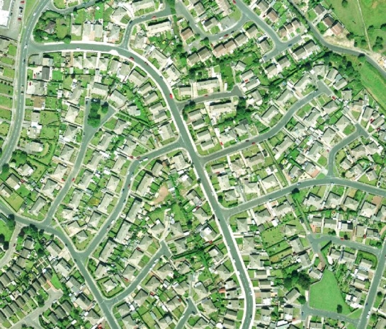
Figure 1: Priory Estate, Monk Bretton, showing pattern of cul-de-sacs.
Cities Revealed aerial photography © the GeoInformation Group, 2002
The vast majority (88% by area) of the land in this zone has been characterised as of residential character. The next most extensive land use (6% by area) is institutional complexes, mostly government funded schools and their playing fields. Schools built during this period were generally constructed using building systems such as those developed by the public sector CLASP [Consortium of Local Authorities Special Project] group. Buildings constructed using the CLASP system (in common with private sector systems such as Vic Hallam’s ‘Derwent system’) feature significant amounts of prefabricated materials and are generally formed of prefabricated steel frames infilled with asbestos, wood or concrete panels, under flat roofs. The system was regarded as being particularly suitable for construction on sites liable to mining subsidence (CLASP n.d.). There are also a rising number of private and NHS old people’s homes within the zone.
Few settlements within Barnsley have not been altered by late 20th century suburbanisation, which has significantly expanded the amount of housing in the district. Within the rural west of the district, seen as attractive for those seeking a less urban lifestyle, newly built estates on the edges of the existing villages have sometimes doubled the size of these settlements. Further east, many areas of late 20th century housing have developed as commuter belts because of the close proximity of the M1 motorway and public transport links to Barnsley itself.
Relationships with Adjacent Zones
This zone is often directly adjacent to areas of earlier suburbanisation or surrounds the historic core of rural villages, reflecting a continuing trend towards the expansion of the suburban landscape. This expansion has been driven partly by continued population growth, but also by a general increase in prosperity - resulting in increased property ownership and the consequent movement of population from the urban centres to lower density urban fringe locations.
Small areas of late 20th century infilling will be found within other zones, where they are too small to have registered as character areas in their own right. Within Nether Hoyland there are some slightly larger areas of private suburbanisation that have been included in the ‘Planned Industrial Settlements’ zone because it predates the closure of local mines; although privately built it would still have housed families connected with the mines and associated industries.
Inherited Character
The majority of the suburban development within this zone (83% by area) has taken place on land that was in agriculture use until the mid to late 20th century. This is a typical feature of this period of suburban expansion, where small villages are expanded and suburbs grow around the edges of towns, sometimes linking former villages to a larger conurbation. Often little of this former agricultural character is visible within the modern estates; 81% of the units recorded by the project that fall within this zone are rated as having fragmentary or invisible legibility of past landscapes. This is a result of the large scale on which some of these areas developed, with estates over writing existing field boundary patterns. Where aspects of the former field pattern do survive these tend to be either where an estate has been built in phases, with a field boundary surviving as a tidemark between the phases, or on the edges of the estate, where housing runs up to the edges or a former field.
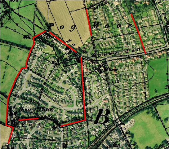
Figure 2: ‘Barnsley Western Suburbs’ showing fossilised field patterns (red Lines).
Cities Revealed aerial photography © the GeoInformation Group, 2002 overlaid by 1855 OS map © and database right Crown Copyright and Landmark Information Group Ltd (All rights reserved 2008) Licence numbers 000394 and TP0024
The 17% of the zone that was not agricultural land prior to suburban expansion consisted of a mix of residential, extractive, institutional, industrial and ornamental landscapes. Amongst these are areas of former allotment gardens. These had developed in abundance around the colliery settlements of the district in the early 20th century, but many have been redeveloped for housing in the late 20th century, as suburbanisation has put pressure on surrounding land. This pattern can also be seen in other character zones, where late 20th century infilling has occurred on allotments and playing fields, but where the areas affected are too small to be pulled out as separate character areas.
Another landscape type impacted upon by late 20th century suburbanisation has been private parkland. There are several examples of late 20th century housing being built upon the edges of small 18th and 19th century parks or deer parks. Aside from some fragments of boundary, generally little of these ornamental landscapes survives. Similarly, where industrial and extractive sites have been over built by late 20th century housing, there is rarely much sign of the former landscape.
An exception to the general trend for low legibility of former landscapes is found in the north of the ‘Suburban Barugh’ character area. The area has a predominantly modern character that gradually developed after the closure and infilling of the Barnsley Canal, which ran along the north west edge of the area and closed in 1953 (Glister 1996, 219). However, housing at Low Barugh was originally stimulated by the proximity of the canal and, although most of the small terraced houses here have been demolished and replaced by 20th century housing, the earlier church and pubs have survived this redevelopment.
Later Characteristics
The main period of historic character in this zone stretches from the 1960s to the present day and, as a result, the dominant characteristics of this zone are, at the time of this study, continuing to form.
Character Areas within this Zone
Map links will open in a new window.
- Suburban Ardsley (Map)
- Suburban Ardsley Bridge (Map)
- Barnsley Western Suburbs (Map)
- Suburban Barugh (Map)
- Suburban Birdwell (Map)
- Suburban Brierley (Map)
- Suburban Carlton (Map)
- Suburban Cawthorne (Map)
- Crane Moor (Map)
- Suburban Cudworth (Map)
- Suburban Darfield (Map)
- Suburban Dodworth (Map)
- Suburban Hoyland Swaine (Map)
- Suburban Kexbrough (Map)
- Suburban Lundwood (Map)
- Monk Bretton Suburban Expansion (Map)
- Suburban Penistone (Map)
- Suburban Pilley (Map)
- Suburban Royston (Map)
- Suburban Shafton (Map)
- Suburban Silkstone (Map)
- Suburban Silkstone Common (Map)
- Suburban Staincross and Mapplewell (Map)
- Suburban Thurgoland (Map)
- Suburban Thurlstone (Map)
- Suburban Thurnscoe (Map)
- Suburban Wilthorpe (Map)
- Suburban Wombwell (Map)
- Suburban Worsbrough Bridge (Map)
Bibliography
- CLASP
- n.d. CLASP Consortium [online]. Available from:
http://www.clasp.gov.uk/NetBuildPro/process/6/History.html [accessed 14/03/08]. - Glister, R.
- 1996 The Conception and Construction of the Barnsley Canal. In: B. Elliott (ed.), Aspects of Barnsley 4. Barnsley: Wharncliffe Publishing, 215-114.