Industrial Settlements
Summary of Dominant Character
The areas of housing within this zone are intimately related to developments in industry and the need to house the expanding populations that came with this. The industries include wool manufacturing, nail making, steel working, iron working, linen working and coal mining. These housing developments generally date to the 19th century and largely consist of terraced houses, but also include some areas of semi-detached housing. The form of the settlements is fairly irregular and key trends in the positioning of these industrial settlements include close proximity to railways and canals, ribbon development along existing roads and establishment on areas of former common or green associated with an earlier settlement. There are some examples of irregular expansion on the edge of an existing historic core.
Settlements associated with water-powered industries tend to be found in the west of the district, running along the narrow valleys of the river Don. The settlements east of this are often associated with coal mining, although some were earlier associated with other industries and later developed into predominantly mining settlements. Many of the settlements in the east of the district were later developed with large areas of planned housing estates, which surround the earlier irregular terraces within this zone.
Industrial settlements often feature allotment gardens associated with the workers housing. Large areas of these can be seen on historic OS maps of these settlements, although many are now in neglected conditions or have been overbuilt during the 20th century. Other facilities included football and cricket pitches, recreation grounds and parks. In the mining villages these facilities were generally provided by the Miners Welfare Fund, the product of a levy paid by colliery companies of 1d on every ton of coal produced following the Mining Industry Act of 1920 (Griffin 1971, 170). These developments are often part of a phase of later improvements to the original industrial settlement.
Relationship with Adjacent Zones
The most obvious relationship between this zone and others is with the ‘Industrial’ and ‘Post Industrial’ zones, where the sites of the concerns that influenced the development of these settlements are located. The collieries associated with the mining settlements are all now disused and mostly fall within the ‘Post Industrial’ zone, although the former extractive sites associated with ‘Silkstone Common’ were worked on too small a scale to warrant separation from the rural landscapes in which they were situated. The water powered industries in the west of the district mainly fall within the ‘Industrial’ zone.
There are many comparisons that can be made between the ‘Industrial Settlements’ zone and ‘Planned Industrial Settlements’. Like many of the villages within this zone, most of the ‘Planned Industrial Settlements’ were developed to house a mining population, however, the planned settlements have a greater level of organisational planning and the developments are built on a larger scale. There are streets within the ‘Industrial Settlements’ zone that have more designed characteristics but these are too small to pull out as a separate zone. A good example of this is South Yorkshire Buildings in Silkstone Common. These were laid out in a regular pattern surrounded by small allotment gardens. This, however, contrasts with the rest of the settlement, which consists of terraces strung out along existing roads.
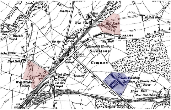
Figure 1: ‘Industrial Settlement’ at Silkstone Common: area of planned housing built by the South Yorkshire Coal and Iron Company in 1877 (Bayliss 1995, 14) shown in blue with small collieries marked in red.
1907 OS maps © and database right Crown Copyright and Landmark Information Group Ltd (All rights reserved 2008) Licence numbers 000394 and TP0024
In some cases ‘Industrial Settlements’ have developed large areas of planned housing, conforming to garden suburb design styles; these areas have been recorded within the ‘Planned Industrial Settlements’ zone.
Inherited Character
There were important industries within South Yorkshire prior to the industrial developments of the 19th century. A number of historic settlements within the Barnsley district had strong associations with these industries: Thurlstone, Ingbirchworth, Cawthorne, Hoyland Swaine and Silkstone have been connected with wool and linen weaving, nail making and glass making. These villages have not been included within this zone as the industries and associated workers housing developed within the historic village rather than being the driving force for the establishment of new settlements.
From the medieval period onwards the growth and development of villages was affected by patterns of land ownership. Population movement was controlled, often to prevent migrant labourers becoming a burden upon poor rates, and this model continued in many settlements into the 19th century (Hey 1986, 240). Where townships asserted less control on the incoming population this often lead to a growing population working in a wide variety of industrial occupations, as with some of the established settlements above. With the increases in industrialisation in the 19th century, there was a rise in the establishment of new industrial communities outside of the more controlled historic settlements. From the 16th century, squatter settlements on the edge of areas of common land were common (ibid, 170), but with the enclosure of many commons in the 18th and 19th century (see ‘Surveyed Enclosure’ zone) this practice became more controlled, sometimes leading to the deliberate establishment of workers housing by large land holders and industrialists.
A significant number of the settlements within this zone follow this pattern and were established on areas of common, as the number of placenames including Green or Common suggest. Many of these areas had been subject to surveyed enclosure and the regular patterns that this created in the landscape can still be seen in the layout of housing within ‘Birdwell’, ‘Higham and Barugh Green Miners Housing’, ‘Hoyland Common’, ‘Hunningley Terraces’, ‘Silkstone Common’ and ‘Wortley Mill Workers Housing’. Another common feature of these settlements is housing built along turnpiked roads and other enclosure period roads that were built across the commons.
Access to new resources was increased by the enclosure of the commons, but the location of these resources away from earlier villages made it necessary to draw a large workforce to a new location. The development of Elsecar is a good example of this. The new colliery at Elsecar was located away from existing settlements and the owner Earl Fitzwilliam had difficulty recruiting a workforce, so between 1796 and 1798 he built, converted or repaired 42 houses in the area (Medlicott 1998, 156). These homes were built to a higher standard than those of some other early industrial settlements, which consisted of very small cottages, sometimes built as back-to-backs (which housing was often the first to be demolished in later years).
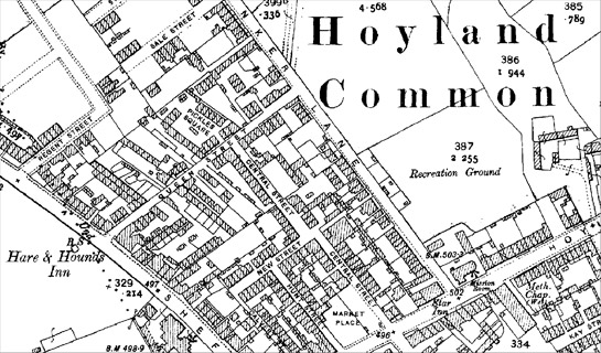
Figure 2: Hoyland Common: a settlement with a dense irregular pattern of housing, including some back-to-back properties that have since been demolished.
1905, 25 inch OS © and database right Crown Copyright and Landmark Information Group Ltd (All rights reserved 2008) Licence numbers 000394 and TP0024
With the development of coal mining in the area, ‘Industrial Settlements’ specifically associated with collieries grew in number. Early colliers would have lived within a nearby village, but from the late 18th century small row housing developed - either near to an existing settlement or near to the pit shaft (Hey 1986, 221). Many of the collieries in Barnsley had a small number of houses directly adjacent to the colliery, although, like other early industrial housing, very few of these pit head terraces survive. In some cases the industrial settlement expanded around these terraces, such as at Jump, but often a later, larger industrial settlement was located further away from the mine. Many of the early terraces have been removed as part of the redevelopment of colliery sites or were replaced during housing improvements in the 1980s, but a surviving example is ‘Woolley Colliery Housing’. These homes are still lived in and would have once housed the workforce at Woolley Colliery, which closed in 1987 (Gill 2007). Some smaller areas of pit side housing also survive, but due to their small size these have been included within surrounding zones. Examples include Monk Terrace, adjacent to the former Monk Bretton Colliery, which is included within the ‘Municipal Suburbs’ zone and Ratten Row, north west of Crane Moor, which is included in the ‘Assarted Enclosure’ zone. Ratten Row is now in a very isolated position but 19th century OS maps show shafts adjacent to the housing and several collieries in the surrounding area (none of which remained in use past the very early 20th century). By the 1970s most of the row had been knocked down; the remaining property is an amalgamation of several terraced houses knocked together.
The concentration of colliery settlements in the central and eastern parts of the district is due to the geology of the area. The earliest collieries were located on the shallow coal seams in the west but by the middle of the 19th century these collieries were beginning to become exhausted and advances in the technologies of transport, ventilation and pumping were beginning to make the exploitation of the deeper seams further east a reality (Hill 2001, 16). This led to a vast increase in mining in the district and a subsequent need to house the increased colliery workforce.
The intense development of the coal resources in the east of the district is likely to be the reason for more industrial settlements developing right on the edge of existing historic villages. ‘Bolton Upon Dearne Terraces’, ‘Unplanned Cudworth’, ‘Darfield and Low Valley’, ‘East Darton’, ‘Royston Terraces’ and ‘Wombwell Terraced Expansion’ are all areas where the industrial settlement developed on the edge of a small, nucleated village. This sometimes leads to settlement patterns that reflect earlier medieval field systems, such as the strips still visible at Darfield.
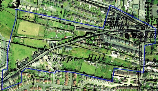
Figure 3: Snape Hill, Darfield - area of ‘Industrial Settlement’ outlined in blue, showing housing within former field boundaries.
Cities Revealed aerial photography © the GeoInformation Group, 2002 overlaid with 1854 OS mapping © and database right Crown Copyright and Landmark Information Group Ltd (All rights reserved 2008) Licence numbers 000394 and TP0024
The positioning of industrial developments away from older settlements was sometimes a deliberate act on behalf of a land owner, to keep ugly housing and industrial concerns away from their hall and out of their views of the countryside. The small estate village of Hickleton in Doncaster is located alongside the 18th century hall and 19th century private parkland (English Heritage 2001) and consists of well preserved 18th and 19th century buildings. The village was maintained as a rural settlement despite the inception of Hickleton Main Colliery, whose workforce was located away further away - in Goldthorpe and Thurnscoe (Hey 1981, 360). Within Thurnscoe the earlier phase of terracing has been subsumed by the later planned settlement, but the more substantial industrial settlement at Goldthorpe remains. A similar pattern can be found at Worsbrough, with the industrial activities around Worsbrough Canal Basin and elsewhere in Worsbrough Dale being separated from the small village adjacent to Worsbrough Hall.
Industrial settlements and their associated industries tend to be closely related to transport links. ‘Elsecar and Milton Industrial Settlement’, ‘Hoyle Mill Terraces’, ‘Hunningley Terraces’, ‘Worsbrough Dale’ and ‘Wombwell Terraced Expansion’ all developed alongside the canals that ran through Barnsley, linking their industries to wider markets. The development of the railways within the district in the mid 19th century supplemented this network, providing better transport links to wider areas. ‘Millhouse Green’, ‘Oxspring’, ‘Penistone Industrial Expansion’, ‘Spring Vale’ and ‘Wortley Mill Workers Housing’ were primarily positioned for their industries to take advantage of the fast and steep waterways of the river Don, but the coming of the railway allowed these industries to expand.
Later Characteristics
The industrial settlements in the centre and east of the district all went on to expand in the 20th century and develop areas of ‘Planned Industrial Settlement’, as the rich coal reserves surrounding them were increasingly exploited. The impact of this later development on the earlier phase of settlement often included building on former allotments and the demolition of some of the earliest phases of housing and replacement with council built homes. Housing styles in these later developments were very different from the small, dense terraces of the early industrial settlements (see ‘Planned Industrial Settlements’).
The 1970s and 80s saw the closure of many of the industries that these settlements were established around, leading to significant hardship in the region. After a period of neglect, the 1990s and early 21st century have seen a concerted effort to improve and regenerate former industrial settlements. This has involved further demolition of cramped housing, sometimes leading to replacement homes being built, but often leaving the land as an area of urban green space. This pattern can be seen at Grimethorpe where the early phase of the industrial settlement has largely been demolished and its terraced housing replaced with hundreds of new homes.
The industrial settlements in rural areas in the west of Barnsley have faired differently following the loss of local industry. These areas are often considered to be desirable locations for people looking for a less urban setting for their homes, leading to the creation of new estates at the edge of the existing villages. Recent changes to these settlements often involve the reuse of industrial areas for housing and an increase in the numbers of public parks and other recreational amenities. At Penistone, this has included reuse of a former industrial railway line as a public cycle route.
The use of industrial settlements as part of the commuter belt has also affected settlements further east. At Barugh, Birdwell, Dodworth and Higham the close proximity to the M1 motorway has led to substantial areas of new private housing alongside the original industrial settlement. These areas have been considered as part of the ‘Late 20th Century Private Suburbs’ zone. An extreme example of this later influence on early industrial settlements is at Crane Moor, south west of Stainborough Park. Here the settlement, which was likely to have been established for miners at the once numerous coal mines in the surrounding area, has been almost fully rebuilt with modern housing.
Character Areas within this Zone
Map links will open in a new window.
- Birdwell (Map)
- Bolton Upon Dearne Terraces (Map)
- Darfield and Low Valley (Map)
- Dodworth Bottom (Map)
- East Darton (Map)
- Elsecar and Milton Industrial Settlement (Map)
- Goldthorpe Terraces (Map)
- Grange Moor (Map)
- Green Moor (Map)
- Hemingfield (Map)
- Higham and Barugh Green Miners Housing (Map)
- Hood Green (Map)
- Hoyland Common (Map)
- Hoyle Mill Terraces (Map)
- Hunningley Terraces (Map)
- Millhouse Green (Map)
- Oxspring (Map)
- Royston Terraces (Map)
- Shafton and Two Gates Miners Housing (Map)
- Silkstone Common (Map)
- Spring Vale (Map)
- Staincross and Mapplewell Industrial Settlement (Map)
- Unplanned Cudworth (Map)
- Unplanned Grimethorpe (Map)
- Wombwell Terraced Expansion (Map)
- Woolley Colliery Housing (Map)
- Worsbrough Dale (Map)
- Wortley mill workers housing (Map)
Bibliography
- Bayliss, D. (ed.)
- 1995 A Guide to the Industrial History of South Yorkshire. Sheffield: Association for Industrial Archaeology.
- English Heritage
- 2001 Register of Parks and Gardens of Special Historic Interest in England: South Yorkshire [unpublished]. London: English Heritage.
- Gill, M.
- 2007 Mines of Coal and other Stratified Minerals in Yorkshire from 1854 [Geo-referenced Digital Database]. Available from: Northern Mines Research Society, 38 Main Street,
Sutton in Craven, KEIGHLEY, Yorkshire, BD20 7HD. - Griffin, A.R.
- 1971 Mining in the East Midlands 1550-1947. London: Frank Cass and Co.
- Hey, D.
- 1981 Industrialised Villages. In: G.E. Mingay, (ed.), The Victorian Countryside, Vol 1. London: Routledge & Kegan Paul, 353-362.
- Hey, D.
- 1986 A Regional History of England: Yorkshire From AD 1000. London: Longman.
- Hill, A.
- 2002 The South Yorkshire Coalfield: a History and Development. Stroud: Tempus Publishing Ltd.
- Medlicott, I.R.
- 1998 Elsecar: the Making of an Industrial Community, 1750-1830. In: B. Elliott (ed.), Aspects of Barnsley 5. Barnsley: Wharncliffe Publishing, 149-172.