Industrial
Summary of Dominant Character
This zone can be split into two quite different landscapes. One is inactive sites of industry that still display significant characteristics of the former industrial activity with surviving buildings and boundaries. These sites tend to date to the late 18th or 19th centuries, although some sites developed from early post-medieval or medieval origins. The other is more recent 20th century industrial concerns, with larger industrial buildings associated with chimneys, tanks and containers. These sites were generally still active in 2003. Late 20th century industry is generally only included within this zone when the buildings are part of an earlier industrial concern that has continued in use, or been rebuilt.
Relationship with Adjacent Character Zones
The ‘Industrial’ zone has a key relationship with contemporary settlement. Industrial activities require a workforce; sometimes this will be drawn to a new area by the promise of work, or the industry will develop near to an existing centre of population. The ‘Industrial Settlements’ and ‘Planned Industrial Settlements’ zones are settlements that specifically developed alongside local industries. Although within Barnsley such settlements were mainly related to coal mining, the iron, glass, wool, linen and steel industries played significant parts in their expansion. The extractive industries are dealt with separately, under the ‘Extractive’ zone, or, where sites have been redeveloped, the ‘Post Industrial’ zone.
Some of the early industries of Barnsley did not lead to the establishment of new settlements but relied upon the population within existing nucleated villages. This is particularly apparent in the west of the district, where woollen weaving and nail making were significant to the local economy. Specific buildings were associated with these craft industries. Nail making required a small forge in the rear of the property; woollen weavers’ cottages had numerous large windows to let light into the work rooms. Surviving evidence for this early industrial activity has generally been considered in the ‘Nucleated Rural Settlements’ zone, however, these industries will be explored further below.
A number of industrial sites are not included within this zone. The majority of these sites have been considered within the ‘Post Industrial’ zone as they consist of industrial developments within large business parks, which have often been developed on areas of former coal extraction. These late 20th century industrial sites consist of plain shed-like buildings and are often mixed with commercial retail developments and large offices. The building style of these industrial units is not always significantly different to that of the adjoining commercial sites. This is in part due to a changing emphasis away from the heavier industries.
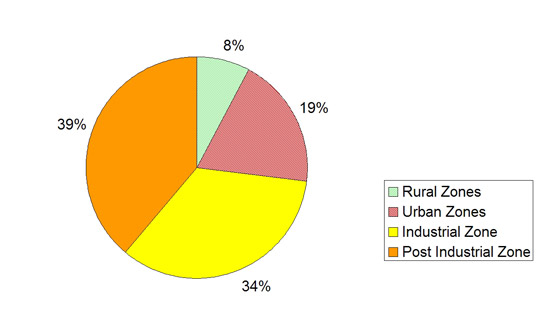
Figure 1: Chart showing which Character Zone sites recorded by the HEC project as Industrial fall within.
The concentration of industries within a distinct geographical location, which is found in Doncaster, Rotherham and Sheffield, has not occurred in Barnsley. This has led to industrial activity being located within most defined character zones. This scattered distribution pattern will be considered below.
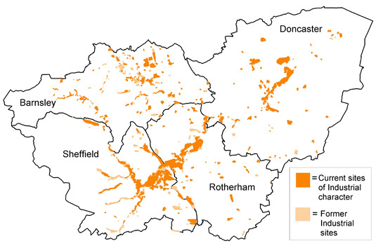
Figure 2: Distribution of current and former Industrial sites across South Yorkshire, according to the HEC project.
Based on OS mapping © Crown copyright. All rights reserved. Sheffield City Council 100018816. 2007
Inherited Character
Water power was a key factor in the early establishment of industry within this district, and in South Yorkshire as a whole. From the medieval period onwards, water power was utilised in the grinding of corn - early documented examples being Hornthwaite Mill and Nether Mill, which were used for milling corn from at least 1486 and 1566 respectively (Nicholson 2001, 91). The fast flow of the river Don, as it cuts down through the steep geology in the west of Barnsley, is ideal for powering mills and as former craft industries became more mechanised, this area developed into a centre for wool working in South Yorkshire.
The Pennine fringe area in the west of Barnsley forms the southern edge of the wool district in Yorkshire, where woollen cloth manufacturing had been prevalent since the late medieval period. Mechanisation first came into the industry in the 13th century, as water powered fulling mills were developed (these pounded and cleaned the wool) (Raistrick 1973, 96). The mill at Oxspring is known to have been a fulling mill from the 14th to the middle of the 19th century, when it was replaced with a wire mill (Nicholson 2001, 141-144). Significant mechanisation did not occur until the 18th and 19th centuries, when scribbling mills, for carding and stretching wool prior to spinning, were developed (Raistrick 1973, 97-98). There were numerous mills related to the various processes involved in wool production in the Penistone area, including fulling mills, scribbling mills and a dye mill, as well as weavers’ cottages in the nearby settlements. Oxspring Mill and Bullhouse Mill were converted to wire mills in the mid 19th century (Nicholson 2001, 131-140) and other wool mills also changed use, particularly in the early 20th century when there was a decline in the cloth industry. At Oxspring and Plumpton Mills parts of the earlier mills survive, despite later modern developments on the sites. Aside from some evidence for earlier water-powered mills, there is generally no evidence of past landscapes within these industrial sites.
Paper manufacturing also began its life as a water powered industry. Within this zone, the Hoyland Fox umbrella works began its life as a paper mill in the late 18th century and Spring Grove paper mill opened in 1834 (Schmoller 1992, 113 and 103). There were other paper manufacturers in the district - at Worsbrough, Monk Bretton and Old Mill. Of these, the earliest was Lewden mill in Worsbrough, which was operating in the early 18th century (ibid, 51), and the latest was Old Mill, of mid 19th century origin, which closed in 1981 (Taylor 1993, 52). These mills have all been demolished and replaced by non-industrial activities; Spring Grove at Oughtibridge remains the only surviving paper mill in the area.
Another significant industry that took its early power from the local rivers is iron manufacturing. Within Barnsley two areas of iron working became well established in the post-medieval period. A bloomery (used to reduce iron ore to produce wrought iron) was working at Rockley from at least the 16th century. This was supplemented by Rockley Low Furnace, which survives as an upstanding building, in the late 17th century. The furnace supplied iron to local nail makers within the district (Hey 1979, 118-9). At Wortley there is evidence for iron working from the 14th century onwards, but the first documented reference to water powered bloomeries is in 1621; in 1658 the bloomeries were rebuilt as a forge. A complex of iron working mills and forges grew up in this small area, including a finery (to remove carbon from the iron and make it more malleable) and a chafery, where wrought iron was reworked before sending it on to the slitting mill or tin mill. The 19th century saw a reduction in demand for wrought iron and the forge closed early in the 20th century (SYAS 2008). However, the sites at Rockley and Wortley have both left substantial remains that are now protected as Scheduled Ancient Monuments.
The iron industry developed in this area because of local iron reserves that run in a diagonal band across Barnsley, broadly parallel with the M1 motorway. Particularly visible are the remains of ironstone mining at Tankersley, which are described within the ‘Post Industrial’ zone. There were numerous bell pits in this area in the late 18th and 19th century, leaving characteristic annular spoil heaps across Tankersley Park. Ironstone from this area mostly supplied the Chapeltown furnace and the Milton and Elsecar Ironworks (Jones 1995a, 80). The site of the Milton ironworks has been fully demolished, so lies within the ‘Post-Industrial’ zone, but parts of the Elsecar ironworks survive through their reuse as engineering workshops associated with Elsecar New Colliery (Bayliss 1995, 21). Elsecar owes the expansion of its industry to the creation of the Elsecar branch of the Dearne and Dove Canal, which was completed in 1798 (Glister 1995, 118). There were some industrial concerns in the area prior to the establishment of the canal, including lime manufacturing (Medlicott 1998, 165), but the canal encouraged the expansion of industries in an area that had previously been fairly isolated from a wider economic market (Medlicott 1987, 108).
When, in the 18th century, iron foundries were separated from the blast furnace (Raistrick 1973, 47), a number of foundry sites developed in Barnsley town. These tended to be mixed brass and iron works. There was also an ironworks at Wombwell and a steel and ironworks in Penistone, along with some small iron casting sites in Mapplewell. The later larger industries developed along the routes of the railway lines that crisscrossed Barnsley in the 19th and early 20th centuries. Most of these sites have been redeveloped for non-industrial activities and have, therefore, not been considered within this zone. However, industrial activities survive within the ‘West Barnsley Industries’ area and at ‘Penistone Industrial Sites’. These sites reflect the enclosure pattern that predated their construction, as the industrial units was built within a regular surveyed enclosure pattern.
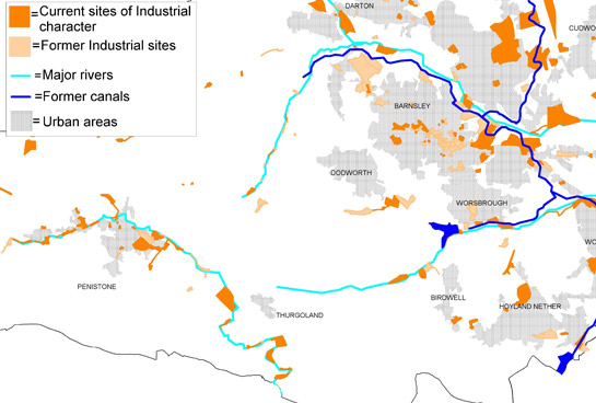
Figure 3: Water powered industries followed the course of Barnsley’s rivers; other 18th and 19th century industrial sites clustered along the Dearne & Dove Canal and the Barnsley Canal. Later industries often developed along the dense network of railway lines that ran across Barnsley from the 19th century.
Based on OS mapping © Crown copyright. All rights reserved. Sheffield City Council 100018816. 2007
A wide variety of iron products came out of Barnsley over the years including nails, wire, plate iron and (in the 19th century) bar iron for use in the railways. Many were produced in the ‘Wortley Metal Workings Area’. Nail making was a craft industry that flourished in settlements across Barnsley including at Mapplewell, Hoyland Swaine, Staincross and Thurgoland. These craft activities are further explored within the ‘Nucleated Rural Settlement’ zone.
The linen industry, which was highly significant for the expansion of Barnsley in the 19th century (Taylor 1993, 25), is also little represented within the ‘Industrial’ zone. Very few examples of linen mills or textile warehouses survive and most of these fall within the ‘Grid Iron Terraced Housing’ zone and ‘Complex Historic Town Cores’ zone. Surviving early textile buildings include Sudgens, which opened in 1904, and the Utilitas works, built in 1867, to producing padded clothing. Sugdens shirt factory closed in 2003 and the Utilitas works closed in 1977 and has been reused as offices of the Barnsley chamber of commerce (Bayliss 1995, 55). A later example of the textile industry in central Barnsley is seen at the SR Gents factory, which opened in 1945 and is now a supply depot for Marks and Spencer’s.
The bleaching of cloth was a significant part of the linen industry in Barnsley. There were numerous bleacheries across the district, many of which encircled Barnsley town. Bleaching required a clean water supply for the washing of the cloth and a large open space (known as a bleachcroft) for the cloth to be hung out to dry. These requirements meant that bleacheries were located away from other industrial areas and urban developments (Taylor 1993, 24). The bleachcroft generally just consisted of former agricultural fields on which the industry made little impact. This means that, in surviving areas, the former landscape is generally legible despite this industrial activity.
Most of the bleacheries of the district are long gone and now lie beneath urban and industrial developments. However, there are survivals at Ardsley, Midland, Redbrook and Swithen. These sites were operating from the late 18th to mid 19th centuries and had generally fallen out of use by the early 20th century. There are several surviving buildings on all of these sites, although they have been reused for a variety of purposes.
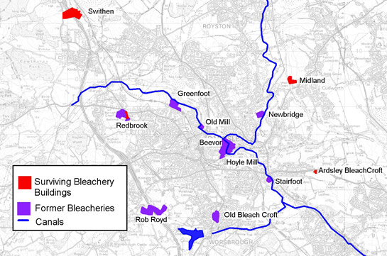
Figure 4: Location of the known bleacheries around Barnsley.
OS mapping © Crown copyright. All rights reserved. Sheffield City Council 100018816. 2007
One of the few historic industries of Barnsley still ongoing at any substantial level is glassmaking. This industry was widespread in the centre of the district by the 19th century, mostly built around the canal system (Ashurst 1992, 5). The Redfearn glassworks was established in 1946 when the Redfearn Brothers glassworks at Old Mill had become too small (ibid, 96-7). The modern sheds cover a large area, removing all traces of the earlier strip fields. The Potter-Ballotini glassworks is broadly contemporary, opening in 1956 (Potters Europe 2007) and producing reflective glass beads for road signs. The current glassworks replaced the Oaks Glass and Bottle Works, which was in operation between 1872 and 1927 and was owned by Sutcliffe, Wade and Dobson (Ashurst 1992, 126). The Beatson Clark glassworks is also a 20th century development on an older site. The Hope Glassworks was opened in 1867 by Ben Ryland and closed in 1928; the site was bought by Beatson Clark in 1929 (ibid, 74). These sites have all been fully redeveloped, removing the buildings of the early glassworks and mostly developing over any sign of former field patterns. However, at the Beatson Clark glassworks the course of the Dove Canal survives in the building pattern.
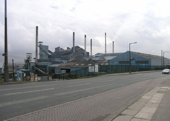
Figure 5: Redfearn Glass Factory.
© Michael Patterson – Creative Common License http://creativecommons.org/licenses/by-sa/2.0/
Later Characteristics
In the west of the Barnsley district evidence for water powered industries often survives quite well. Some of these sites remain as industrial concerns, but where 18th and 19th century mill buildings survive there is a general trend towards their conversion as houses. The rural location of the water powered sites in the west of Barnsley and the growing appeal of these areas for commuters makes the restoration of surviving mill buildings desirable; examples include former mills in Thurlstone, which also fall within a Conservation Area. Most of the remaining industrial buildings at Elsecar also lie within a Conservation Area, as well as being listed buildings. Other sites have been designated as Scheduled Ancient Monuments, including Rockley Furnace and the Wortley forges. The tourist potential of these early industrial sites has been recognised with the development of a heritage centre at Elsecar and the creation of a museum at Wortley Top Forge.
Some of the later large-scale industrial sites within this zone are in the process of closing. There are not the same numbers of manufacturing jobs in the region as there once were and many of these sites are likely to see redevelopment for housing or commercial activities. The remaining industrial sites within the district are now often located in business parks, within generic shed-like structures.
Character Areas within this Zone
Map links will open in a new window.
- Darton Industries (Map)
- Elsecar Industries (Map)
- Hope Glassworks (Map)
- Hoyle Mill (Map)
- Midland Bleachworks (Map)
- Old Mill (Map)
- Penistone Industrial Sites (Map)
- Penistone Water Powered Sites (Map)
- Rockley Furnaces (Map)
- Spring Grove Paper Mill (Map)
- Swithen Bleachworks (Map)
- Wakefield Road Industry (Map)
- West Barnsley Industries (Map)
- West Green Industries (Map)
- Wombwell Foundry (Map)
- Wortley Metal Workings Area (Map)
Bibliography
- Ashurst, D.
- 1992 The History of South Yorkshire Glass. Sheffield: JR Collis Publications, Department of Archaeology and Prehistory.
- Bayliss, D. (ed.)
- 1995 A Guide to the Industrial History of South Yorkshire. Sheffield: Association for Industrial Archaeology.
- Glister, R.
- 1995 The Dearne and Dove Canal. In: B. Elliott (ed.), Aspects of Barnsley 3. Barnsley: Wharncliffe Publishing Limited, 116-132.
- Hey, D.
- 1979 The Making of South Yorkshire. Ashbourne: Moorland Publishing.
- Jones, M.
- 1995 Ironstone Mining at Tankersley in the Nineteenth Century for Elsecar and Milton Ironworks. In: B. Elliott (ed.), Aspects of Barnsley 3. Barnsley: Wharncliffe Publishing Limited, 80-115.
- Medlicott, I.R.
- 1987 The Development of Coal Mining on the Norfolk and Rockingham-Fitzwilliam Estates in South Yorkshire. Yorkshire Archaeological Journal, 59, 103-118.
- Medlicott, I.R.
- 1998 Elsecar: the Making of an Industrial Community, 1750-1830. In: B. Elliott (ed.), Aspects of Barnsley 5. Barnsley: Wharncliffe Publishing, 149-172.
- Nicholson, V.
- 2001 Upper Don Watermills. Sheffield: Hallamshire Press.
- Potters Europe
- 2007 Potters Europe, History [online]. Available from: www.potterseurope.org/about_history_potters.asp [accessed 16/1/08].
- Raistrick, A.
- 1973 Industrial Archaeology. London: Paladin Books.
- SYAS
- 2008 South Yorkshire Sites and Monument Record [dynamic MS Access – GIS database] Sheffield, South Yorkshire Archaeology Service. Available by appointment with SYAS, Howden House, 1 Union Street, Sheffield, S1 2SH. Email: syorks.archservice@sheffield.gov.uk [accessed 26/02/08].
- Taylor, H.
- 1993 Bleachworks of Barnsley and their Industrial Archaeology. In: B. Elliott (ed.), Aspects of Barnsley. Barnsley: Wharncliffe Publishing, 25-61.