Late 20th Century Replanned Centres
Summary of Dominant Character
The centre of Barnsley, like many large towns and cities across the country, was subject to significant alteration between the 1960s and 80s. This modernisation of the centre consisted of the development of large concrete shopping centres, multi-storey car parks, wide dual carriageway road systems and other transport links. Preparing the town for the car was an important part of these developments, in a period where its growing importance in urban life was becoming clear. The new road patterns were designed to bypass the centre of the town, segregating the car from pedestrians. The resulting forms often cut through former building patterns and modern developments were then built in relation to the new patterns.
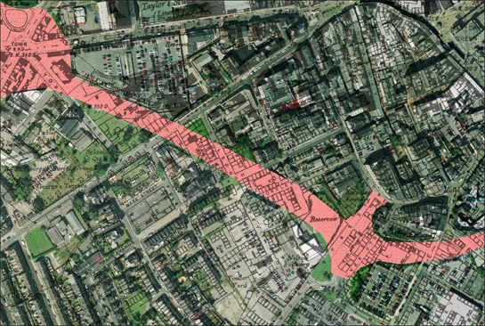
Figure 1: Historic street patterns, shown on 1893 OS map, cut through by the West Way dual carriageway (coloured in pink).
Cities Revealed aerial photography ©: the GeoInformation Group, 2002; Mapping © and database right Crown Copyright and Landmark Information Group Ltd (All rights reserved 2008) Licence numbers 000394 and TP0024
This zone is made up of a fairly even mix of character types. ‘Commercial’ includes a mix of indoor shopping centres, large shops and covered markets; ‘Communications’ includes open car parks, large roads bypassing the city centre and the transport interchange, which includes a bus and train station; ‘Ornamental, Parkland and Recreational’ includes a modern sports complex and football stadium; ‘Institutional’ includes the council offices around the historic core and Barnsley Hospital to the north west of the city centre.

Figure 2: Broad Character types that make up the current landscape of the ‘Late 20th Century Replanned Centres’ Zone (percentages by area).
Relationships with Adjacent Character Zones
This zone is intimately related to the historic core of Barnsley. The centre of the town has seen various phases of redevelopment, since its origins as a medieval market town, and these redesigns and rebuilds have continued into the 21st century. This zone includes those areas where modern development has overwritten areas of medieval and early post-medieval settlement and radically altered the earlier street patterns; where there is a clear continuity of plan form, modern buildings have been considered as part of the ‘Complex Historic Town Cores’ zone.
Barnsley began to expand well beyond its medieval core in the 19th century. The earliest major expansion of the town took place around May Day Green and across the recently enclosed areas of former common south of the town centre. These areas were rapidly filled by terraced housing and weavers’ cottages, with their basement workshops. The process of demolition and redevelopment of the industrial and residential areas within this zone is similar to that which occurred within the ‘Municipal Suburbs’ zone. In fact, the creation of late 20th century municipal housing estates could be considered part of the replanning of the centre of the town.
Inherited Character
The very nature of the ‘Late 20th Century Replanned Centres’ zone means that there is generally little visible of the landscape prior to the late 20th century. The replanning of Barnsley town was not as severe and extensive, however, as similar projects in Sheffield and Doncaster and in places there is some legibility of the past landscape.
One of the oldest landscapes to be overwritten by the replanning of Barnsley was that of May Day Green. When Barnsley was relocated from Old Town to focus around Market Hill, in around the 13th century, this land remained common land (Elliot 2002, 27-9). By the 18th century, the green had been surrounded by wiremakers’ workshops and cottages but the triangular form of the green remained largely unchanged throughout the 19th and early 20th centuries, only for it and much of the street patterns to the south and east to be radically altered by the construction of the covered markets and surrounding shopping precincts in the 1970s and 80s. However, the edges of the green are partially preserved by existing roads.
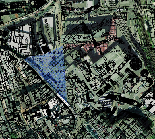
Figure 3: Former May Day Green, highlighted in blue.
Cities Revealed aerial photography © the GeoInformation Group, 2002 overlain by 1893 OS mapping © and database right Crown Copyright and Landmark Information Group Ltd (All rights reserved 2008) Licence numbers 000394 and TP0024
Barnsley expanded rapidly in the 19th century, moving from a successful but small market town to a place with significant industrial concerns. Linen manufacturing was primarily responsible for Barnsley’s rapid increase in population in the first half of the 19th century (Taylor 1993, 25). South of the town centre large numbers of weavers’ cottages were built, along with other terraced housing. The weavers’ cottages housed up to 6 looms per building and were built and owned by linen manufacturers for renting out to hand loom weavers. The looms were generally placed in a basement workshop, as damp conditions made it less likely for the linen to snap during weaving (Taylor 1995, 42-3). Back-to-back housing and dense courtyards were common within this area and a parliamentary report of 1840 (cited in Taylor 1995, 51) describes weavers as “degraded being(s)”. Hand loom weaving became less common in Barnsley from the 1860s, when mechanised power looms came into dominance (Jones 2000a, 49), but the buildings remained until the slum clearance regimes of the 1960s and 70s (see ‘Municipal Suburbs’ zone, for more detail). This resulted in much of this early housing having been cleared before the establishment of the West Way dual carriageway in the 1980s, which substantially altered the layout of this area of Barnsley. Much of this area was then utilised for warehousing and commercial units, although currently much of the warehousing is being redeveloped for offices.
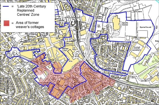
Figure 4: Area south of Barnsley's commercial centre dominated by weavers' cottages in the 19th century (in red), in relation to the 'Replanned Centres' zone.
Modern maps © Crown copyright. All rights reserved. Sheffield City Council 100018816. 2007
Barnsley also had numerous warehouses and mills associated with the linen industry, many of which were located around Town End. The sites of these mills fall within the north west of this zone, as well as within the ‘Complex Historic Town Cores’ zone and the ‘Grid Iron Terraced Housing’ zone. These mills were developed to house power looms, as hand loom weaving went into decline, but developments occurred at too slow a pace and the industry went into a steady decline from the mid 19th century onwards (Jones 2000, 59). These mill sites have been heavily affected by the new road patterns of the late 20th century and associated commercial developments.
In spite of the replanning of this area, fragments of the street pattern associated with the 19th century expansion of Barnsley survive. Some of the streets that survived the later replanning are: Eldon Street, Peel Street and Pitt Street, which were laid out c.1838 (Whitworth 1998). These streets were themselves a replanning of the town and Eldon Street, in particular, had cut through the medieval pattern of long narrow crofts that ran east of Market Hill. Within this zone, the grid patterns of the 19th century landscape are particularly clear in the very south of the zone, around Joseph Heller Street.
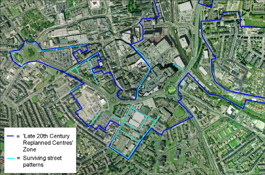
Figure 5: Street patterns associated with earlier terraced housing and weavers' cottages surviving within the ‘Late 20th Century replanned Centres’ Zone.
Cities Revealed aerial photography © the GeoInformation Group, 2002
Despite the decline in the linen industry there were still numerous working opportunities for the population of Barnsley. The rapidly increasing coal industry drew in many of the former male weavers, as did local iron foundries and glassworks. There were several Iron and Brass foundries within this zone - smaller sites surrounded by housing and larger ones alongside the railway line, adjacent to the former Gas Works. The iron industry declined from the mid 19th century, as a result of continued competition with mild steel (Andrews 1975, 55), but large foundries remained in Barnsley until the mid 20th century; their sites are now covered by substantial shopping precincts, built in the late 20th century. Most industrial activities have now moved to more peripheral locations.
The centrally located industrial activity in Barnsley in the 19th century led to the construction of substantial railway sidings around Barnsley Station. The railway lines around Barnsley had been developed expressly to service the growing numbers of coal mines and other industrial sites in the district; passenger transport being a secondary consideration (Taylor 2001, 47). The current bus station and council offices in the north of this zone replaced a large area of railway sidings, goods sheds, cattle pens, a timber yard and a foundry associated with the railway. The movement or abandonment of industrial and colliery sites close to the railway and an increasing reliance on road transport led to this wholesale redevelopment.
Within this zone, but further away from the main commercial core, is the site of Barnsley District General Hospital. This broadly corresponds with the site of the former Barnsley Union Workhouse, which was built in 1852 after the formation of the Barnsley Poor Law Union in 1850 (Higginbotham 2000 [accessed 10/04/08]). The site came under the control of West Riding Council in the 1930s and became Barnsley Municipal Hospital. By the 1973 OS mapping the workhouse building had been demolished and modern hospital buildings built in its place, removing all trace of the workhouse.
Later Characteristics
Redevelopment of the commercial, business and entertainment facilities within the urban centre of Barnsley is a continuing process. In the late 1990s and early 21st century, projects to revitalise the region’s economy were instigated and major rebuilding projects in the centre of the town were the result. These have included the replacement of some of the extensive commercial developments of the 60s and 70s, which were considered to be dated and inappropriate for modern shoppers (Yorkshire Forward 2003, 20).
There have also been moves towards creating a more pedestrian friendly environment “placing the needs of people ahead of the needs of their vehicles” (ibid, 34). This has included the redevelopment of the transport interchange and a reduction of private vehicular access to the town centre.
A further step within this ongoing replanning is the addition of more residential properties within the urban centre. This goes against the replanning of the 1970s, which removed extensive areas of housing in favour of commercial developments, and shows how ideas about where people wish to live have changed.
Character Areas within this Zone
Map links will open in a new window.
- Barnsley General Hospital (Map)
- Barnsley Replanned Commercial Centre (Map)
- County Way and the Transport Interchange (Map)
- Metrodome and Football Stadium (Map)
Bibliography
- Andrews, C.R.
- 1975 The Story of Wortley Ironworks. 3rd Edition. Nottingham: R. Milward Printers Ltd.
- Elliot, B.
- 2002 Glimpses of Medieval Barnsley. In: B. Elliott (ed.), Aspects of Barnsley 7. Barnsley: Wharncliffe Books, 23-38.
- Higginbotham, P.
- 2000 The Workhouse [online]. Available from: www.workhouses.org.uk/index.html [10/04/08].
- Jones, M.
- 2000 Destination Barnsley: The migration History of a Linen Weaving Family, 1798-1932. In: B. Elliott (ed.), Aspects of Barnsley 6. Barnsley: Wharncliffe Publishing, 47-66.
- Taylor, H.
- 1993 Bleachworks of Barnsley and their Industrial Archaeology. In: B. Elliott (ed.), Aspects of Barnsley. Barnsley: Wharncliffe Publishing, 25-61.
- Taylor, H.
- 1995 Taylor Row and the Handloom Weavers of Barnsley. In: B. Elliott (ed.), Aspects of Barnsley 3. Barnsley: Wharncliffe Publishing, 39-64.
- Taylor, W.
- 2001 South Yorkshire Pits. Barnsley: Wharncliffe Books.
- Whitworth, A.
- 1998 John Whitworth, Architect and Surveyor of Barnsley. In: B. Elliott (ed.), Aspects of Barnsley 5. Barnsley: Wharncliffe Publishing, 189-200.
- Yorkshire Forward
- 2003 Remaking Barnsley: Strategic Development Framework 2003-2033 [online]. Available from: www.remakingbarnsley.co.uk/ [accessed 10/04/08].