Strip Enclosure
Summary of Dominant Character
This zone is characterised by long thin curving fields, sometimes all running in the same direction and sometimes forming a patchwork pattern across the landscape. These patterns are interspersed with more irregular enclosures with some curving boundaries. In the west of the district, field boundaries tend to be drystone walls, further east there are many more hedges, sometimes containing mature trees. The western fields tend to have more land set aside as pasture, with a trend towards more arable farming in the east.
Most of the enclosures date to the 16th and 17th century and ‘Carlecotes Town Field’ and ‘Penistone and Hoyland Swaine Town Fields’ have 16th and 17th century farm buildings (English Heritage 2005b) scattered across the enclosed fields.
Relationships with Adjacent Character Zones
Areas of ‘Strip Enclosure’ are almost exclusively found in association with ‘Nucleated Rural Settlements’. Where this is not the case, it is possible that an earlier settlement has shrunk to such an extent that it can no longer be recognised. This contrasts with areas of ‘Assarted Enclosure’ where the settlement pattern tends to be one of dispersed farmsteads. This relationship has long been recognised in landscape studies. Rackham (1986, 3-5) recognises the distinction between ‘planned’ and ‘ancient’ countryside and this division is broadly comparable to the division between ‘nucleated’ and ‘dispersed’ settlement described by Roberts and Wrathmell (2000). In the west of Barnsley the Strip Enclosure zone is surrounded by and interspersed with the Assarted Enclosure zone, showing a blurring between planned and irregular landscape types in this region.
There were large areas of strip fields in the east of the district, making up a more clearly planned landscape, but modern agricultural practices, resulting in significant boundary loss, have meant that these fields have been categorised as part of the ‘Agglomerated Enclosure’ zone.
Inherited Character
Previous landscape use defines this zone. The pattern of strip fields has resulted from piecemeal enclosure of former open fields. In the medieval period, large open areas of land were cultivated in long thin unhedged strips that were “individually owned but farmed in common” (Taylor 1975, 71). The land would be ploughed by oxen into separate ridges and often the practice of turning the plough team at the end of each ridge or strip would produce a characteristic reverse ‘s’ shape, in plan, that could be fossilised by later enclosure (ibid, 78-80).
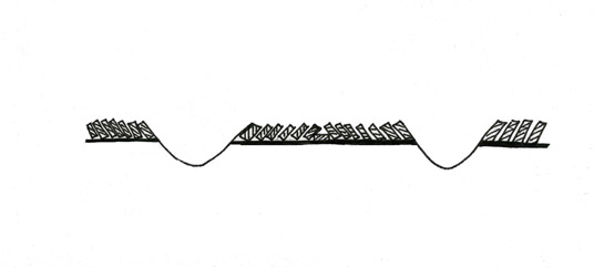
Figure 1: Formation of plough ridge and associated plough furrows (Marchant, after Taylor 1975 Figure 9b).
Within open field systems, individual ownership of strips was scattered throughout the common fields, meaning that people could own a mixture of the good and bad soils. This pattern of land ownership made communal farming necessary, as some strips within the same unhedged area could not be used for corn whilst others were turned to fallow and grazing. Settlements (or towns) typically had three large fields of strips that could be farmed in rotation (a pattern common across the English Midlands) (Hall 2001, 17). However, the areas of town field within the Barnsley district are quite small, suggesting a smaller scale use of this pattern.
Open field farming continued at ‘Roughbirchworth Strip Fields’ into the 17th century (Hey 2002, 32) but generally open fields had been enclosed well before then. From the 15th century farmers were exchanging dispersed strips throughout a town field to obtain contiguous blocks of land that could be enclosed (Rackham 1986, 170).
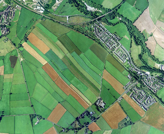
Figure 2: Roughbirchworth enclosed strip fields showing a characteristic reverse s shape.
Cities Revealed aerial photography © the GeoInformation Group, 2002
Fossilisation of the pattern of former strips by post-medieval walls and hedges is clearest at: ‘Roughbirchworth Strip Fields’, ‘Thurlstone Town Fields’ and ‘Penistone and Hoyland Swaine Town Fields’. At Penistone there are also crop marks showing former ridge and furrow patterns. West of Hoyland Swaine land was still marked as “Town’s Field” on the first edition O.S. maps.
Later Characteristics
There has been some boundary loss within the Strip Enclosure zone but this has occurred on a less significant scale than that seen to the east of the district. This difference is in part due to the different land uses. Sheep rearing is a significant farming industry around Penistone, to the west, but much of the lower land to the east has retained its arable use and so here modern farming methods have led to boundary removal.
Around Worsbrough the driving factor for boundary removal was the coal industry. Barrow Collieries were located just north of the surviving area of strip fields; they were the cause of significant alteration to the landscape. Their influence reached into this zone but didn’t heavily alter the field pattern. Some small-scale coal mining and sandstone quarrying also took place at ‘Far Coates Strip Fields’.
Across this zone, and Barnsley as a whole, there has been modern expansion and alteration to surviving farms. This has often seen the introduction of modern corrugated sheds.
Character Areas within this Zone
Map links will open in a new window.
- Carlecotes Town Field (Map)
- Cudworth Town Fields (Map)
- Far Coates Strip Fields (Map)
- Howbrook Strip Fields (Map)
- Ingbirchworth Town Fields (Map)
- Pashley Green (Map)
- Penistone and Hoyland Swaine Town Fields (Map)
- Roughbirchworth Strip Fields (Map)
- Silkstone Open Fields (Map)
- Thurgoland Town Field (Map)
- Thurlstone Town Fields (Map)
- Worsbrough Strip Fields (Map)
Bibliography
- English Heritage
- 2005 Listed Building System Data [unpublished MIDAS dataset export in xml format]. Swindon, English Heritage National Monuments Record. Available from: National Monuments Record Centre, Kemble Drive, Swindon.
- Hey, D.
- 2002 A History of Penistone and District. Barnsley: Wharncliffe Books.
- Hall, D.
- 2001 Turning the Plough. Midland Open Fields: Landscape Character and Proposals for Management. Northampton: Northamptonshire County Council and English Heritage.
- Rackham, O.
- 1986 The History of the Countryside. London: J.M. Dent.
- Roberts, S. and Wrathmell, S.
- 2000 An Atlas of Rural Settlement. London: English Heritage.
- Taylor, C.
- 1975 Fields in the English Landscape. London: J.M Dent.