Sub-Rural Fringe
Summary of Dominant Character
The historic character of this zone is defined by an open landscape with strong rural indicators such as open space, relict field boundaries, high levels of woodland and a general absence of housing or active industry. Nevertheless, the influence of nearby or surrounding urban settlement has fundamentally altered the zone’s character. All the areas in this zone have previously been dominated by agricultural or, occasionally, industrial character (sometimes both). However these activities have now generally ceased and the management of these landscapes is more concerned with maintaining their amenity value as green spaces, whilst encouraging opportunities for recreation and biodiversity. The character areas within this zone feature a wide variety of character types dating to many different periods. As a result, this zone is often one of character transition, areas of sub-rural character often blending or interlocking with adjacent urban landscapes.
In Sheffield City a number of large areas retain substantial rural characteristics despite having been enveloped by urban settlement in the 19th and early 20th centuries, because the open space has become parkland. In Barnsley a similar process has occurred, but here the areas of ‘Sub-Rural Fringe’ are mostly creations of the late 20th century. Areas of relict countryside and areas of scrub on former industrial sites have been improved for use as urban green spaces, as part of the regeneration of the district.
Relationships with Adjacent Character Zones
This zone is related closely to the suburban landscapes that surround it, having been retained and landscaped for its amenity value.
Inherited Character
The ‘Kendray and Worsbrough Bridge’ character area represents a remnant of agricultural and common land that was surrounded by the expansion of Barnsley town’s municipal suburbs in the 20th century. The public park that now covers most of this land developed in around 1980 (South Yorkshire Forest Partnership 2000), but there are still remnants of older landscapes surviving. There were large areas of common in this area in the 18th century, much of which was enclosed as part of the 1779 Barnsley Parliamentary Award (English 1985). Barnsley cemetery, established in 1860-61 (English Heritage 2005b, Listed Building ref: 333693), retains several boundaries from the regular field pattern of this enclosure award.
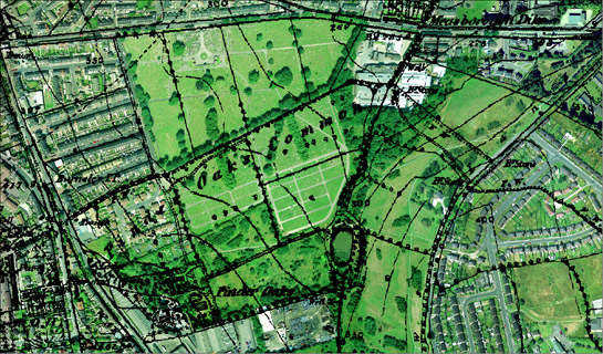
Figure 1: Barnsley cemetery - established on part of the 18th century surveyed enclosure of Pinder Oaks common and on part of the common enclosed by the 1779 Barnsley Parliamentary Award.
Cities Revealed aerial photography © the GeoInformation Group, 2002 overlain by 1855 OS mapping © and database right Crown Copyright and Landmark Information Group Ltd (All rights reserved 2008) Licence numbers 000394 and TP0024
Also within this area was Pinder Oaks house, known from at least the 17th century as the home of William Taylor (Hunter 1831, 292), and used as the Pinder Oaks Maternity hospital between 1921 and 1970 (The Welcome Trust 2007). Although the building has been demolished and the grounds are overgrown, some property boundaries remain visible, as do features that may have been part of the ornamental garden associated with the house. Features like these, within a scrubland landscape, are amongst those most vulnerable to change in this zone.
The ‘Dearne Valley Park’ character area was also developed in 1980 (South Yorkshire Forest Partnership 2000), as part of the regeneration of the district. There were some substantial alterations to the landscape when it was converted into public parkland, but there are still survivals of earlier features.
The early histories of the land here are centred on the medieval priory at Monk Bretton. Adam Fitz Swane founded a Cluniac priory, dedicated to St Mary Magdalene, in c.1154 (Rigold 1968, xi), as was a common practice for the early Norman barons. The site transferred allegiances to the Benedictine order in 1281 (Hey 1986, 59-60) and the monks remained as important landowners in the region until the dissolution of the monastery in 1538. Although partially demolished, there is good survival of the monastery, which in places stands to two storeys; two fishponds also partially survive as earthworks.
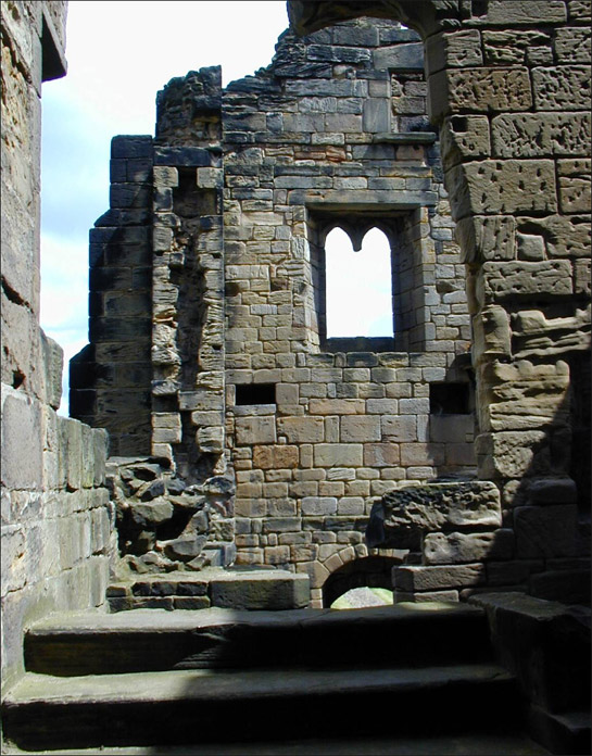
Figure 2: Upstanding remains at Monk Bretton Priory.
© SYAS
Land associated with the monastery includes nearby Cliffe Wood, an ancient woodland that shows some evidence for coppicing and was used as a source of timber for local coal mining and iron ore production (South Yorkshire Forest Partnership 2000). A number of mill sites are also know to have been owned by the monks, which were utilised for corn grinding. The best surviving example is Priory Mill, which is likely to be 13th century in origin but was heavily remodelled in the 17th century (English Heritage 2005, Listed Building Ref: 333721). In 1878, Barnsley Borough Council bought the mill and surrounding land for the development of a sewage farm (Umpleby 2000, 145-6) and the mill then fell into disrepair. It has since been redeveloped as a pub and the surrounding land has become part of the public park.
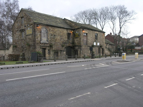
Figure 3: Priory Mill, Monk Bretton.
© Michael Patterson 2006 – Creative Commons License (http://creativecommons.org/licenses/by-sa/2.0/)
Many of the industrial activities of the monks at Monk Bretton were subsequently to be followed by other land owners, throughout the 16th and 17th centuries, but it was not until the 19th and 20th centuries that industrial and extractive use of this area was to have a significant impact on the landscape.
Numerous collieries developed along this stretch of the river Dearne and they were associated with large numbers of railway lines running from all points of the compass, curving and crossing one another to reach each colliery. These have left their impact on the landscape in the form of linear earthworks that have often become the route for new footpaths through the area. This is also true for the course of the Dearne and Dove Canal; the infilled canal is now a footpath running thorough Cliffe Wood.
Another significant industry in Barnsley was linen production. Within this area there were several sites associated with this industry. These included a chemical mill producing bleaches (Umpleby 2000, 143); Hoyle Mill Bleachworks and Beevor Bleachworks, which were both in operation in the late 18th to 19th century (Taylor 1993, 28-32, 40-42); and a calendering works where cloth was “pressed under rollers for smoothing or glazing” (Shorter Oxford English Dictionary 1973), which was also part of the Hoyle Mill works (Umpleby 2000, 143). Remains of the mills and bleachworks have been removed by the development of the Dearne Valley Park, leaving little trace of this industrial activity; the bleaching greens themselves would have had little impact on the landscape in the first place, as they were really only areas of land set aside for cloth to be spread out on after washing.
Later Characteristics
As much of this zone has been landscaped and altered in the very recent past, there has been little opportunity for later developments. The forces for change within the zone are likely to involve continuation of this ornamentalising of the landscape, as part of the improvement of public spaces within the district.
Character Areas within this Zone
Map links will open in a new window.
Bibliography
- English, B.
- 1985 Yorkshire Enclosure Awards. University of Hull.
- English Heritage
- 2005 Listed Building System Data [unpublished MIDAS dataset export in xml format]. Swindon, English Heritage National Monuments Record. Available from: National Monuments Record Centre, Kemble Drive, Swindon.
- Hunter, J.
- 1831 South Yorkshire: the History and Topography of the Deanery of Doncaster in the Diocese and County of York, Volume II. London: Joseph Hunter / J.B. Nichols and Son.
- Rigold, S.E.
- 1968 Monk Bretton Priory. Yorkshire Archaeological Journal, 125, 322.
- Sewell, J.
- 1997 Paradise Lost? Sheffield’s Historic Parks and Gardens. In: M. Jones (ed), Aspects of Sheffield 1: Discovering Local History. Barnsley: Wharncliffe Publishing.
- Shorter Oxford English Dictionary
- 1973 Volume 1, 3rd edition. Oxford: Clarendon Press.
- South Yorkshire Forest Partnership
- 2000 Fuelling A Revolution: The Woods that Founded the Steel Country [online]. Available from: www.heritagewoodsonline.co.uk/ [accessed 10/03/08].
- Taylor, H.
- 1993 Bleachworks of Barnsley and their Industrial Archaeology. In: B. Elliott (ed.), Aspects of Barnsley. Barnsley: Wharncliffe Publishing, 25-61.
- The Welcome Trust
- 2007 Hospital Records Database [online]. Available from: www.nationalarchives.gov.uk/hospitalrecords [accessed 10/03/08].
- Umpleby, T.
- 2000 Water Mills and Furnaces on the Yorkshire Dearne and its Tributaries. Wakefield Historical Publications.