Assarted Enclosure
Summary of Dominant Character
This zone is made up of ancient woodlands and ancient irregular enclosure patterns. The key characteristics of these enclosures are that they form small, sinuous or rounded fields, with mainly hedged boundaries. Very little of the land was formerly part of a medieval open field system (see ‘Strip Enclosure and ‘Agglomerated Enclosure’); 62% of land within the zone is recorded by the project as former woodland and a further 14% (953 ha) is still ancient woodland, likely to date back to the medieval period. The past landscape of this zone was clearly heavily wooded. Assart, the term used to describe woodland cleared for cultivation, has, therefore, been used to describe the character of this zone. Other parts of the zone represent the piecemeal enclosure of commons and moors. Most such enclosures date to the medieval or early post-medieval period.
The zone mostly overlies lower and middle coal measures geology; alternating bands of shales, sandstone and coal seams have weathered to produce a rolling hilly landscape with steeper scarps in the west of the zone and where the River Don cuts through the area. Areas of woodland have often survived on these steeper slopes.
Settlement in this zone is generally dispersed in character, with a significant distribution of medieval farm buildings recorded by the South Yorkshire Sites and Monument Record. In the valleys, settlements surround the numerous water-powered industrial sites, some dating from the medieval period, others related to 18th and 19th century industries.
Relationship with Adjacent Zones
This zone forms a fairly cohesive block down the centre of the district with some ‘Nucleated Rural Settlements’ and areas of ‘Strip Enclosure’ interspersed within areas of ‘Assarted Enclosure’. The older irregular field patterns of the Assarted Enclosure zone tend to be associated with dispersed settlements; nucleated settlements are generally related to areas of former open field agriculture. This is not a completely clear cut pattern within South Yorkshire, but it is a general trend.
The majority of surviving deer parks and 18th century private parks are surrounded by this zone, with areas of ancient woodland also found within them. This relationship is likely to be in part due to the former wooded character of the land within this zone, as a link has been made between heavily wooded regions and high numbers of deer parks (Rackham 1986, 123).
Inherited Character
Placename evidence throughout this zone indicates a formerly highly wooded landscape. Anglo-Saxon and early medieval placenames related to woodland and woodland clearance are common. These names may represent existing clearings renamed by Viking and Anglo-Saxon settlers, rather than necessarily providing dating evidence for the clearance itself. What is clear is that large areas of former woodland had been removed by the time of the Domesday survey in 1086, by which point only 13% of the land was recorded as woodland (Jones 2000b, 42-3).
The landscape that results from woodland clearance often contains botanically rich hedgerows. Within this zone there are likely examples within ‘Langsett Ancient Enclosures’, ‘High Hoyland to Pilley Wooded Farmland’ and ‘Ancient Enclosures near Ingbirchworth’. Another common feature of land assarted from woodland is the presence of shaws, belts of woodland running between fields. These may have provided timber and other woodland resources within an otherwise enclosed landscape (Muir 2000, 22-25).
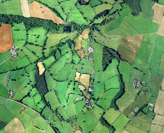
Figure 1: Shaws within the anciently enclosed fields north of Penistone.
Cities Revealed aerial photography © the GeoInformation Group, 2002
Remnants of the ancient woodlands, from which much of this enclosed landscape was assarted, can be seen across this zone. These larger areas of woodland typically survive on steeper slopes, where it has been impractical to clear land for agriculture. The survival of ancient woodland on marginal land is also evident when the woodland distribution is compared with historic parish boundaries; many of the woodlands are on the edge of the parish, sometimes straddling parish boundaries.

Figure 2: Map of Barnsley district showing areas of surviving woodland within the ‘Assarted Enclosure’ zone and their relationship with early 19th century parish boundaries.
(Parish data from Kain and Oliver 2001)
Although much removed from the landscape, woodland was not an insignificant resource in the medieval and later periods. Woodland was an important source of timber, which was the major building material until the 17th century transition to stone (Hey 1979, 131). Woods and wooded pastures were also utilised for fuel production and grazing land from the medieval period onwards (Rackham 1986, 89 &121).
The driving force for the expansion of settlement into wooded areas may have been increases in the population of the area in the early medieval period (Hey 1979, 72). These pressures will also have led to the occupation and irregular enclosure of areas of common such as those at ‘Penistone Assarts’ and ‘Catshaw Ancient Enclosures’. At Catshaw a former moorland landscape is suggested by the absence of hedgerows.
The surviving woodlands often contain earthwork remains of prehistoric and Roman activity. The South Yorkshire Sites & Monuments Record records good examples in Wombwell Woods, for example, including a late Neolithic/ early Bronze Age hengiform monument and Iron Age/Romano-British enclosures. The Wharncliffe area is also rich in remains of Iron Age and Roman industries and earthwork remains of contemporary settlement. This area juts into Sheffield district and is closely related in character to adjoining woodlands within Sheffield’s ‘Assarted Enclosure’ zone, where a large Iron Age and Roman quern making site is located (Butcher 1957).
The landscape of Wharncliffe Chase adds further complexity. In 1252 a grant of free warren was given to the Wortley family, giving them the right to establish a hunting chase or deer park. The resultant chase stretched across a large area of the current parish of Wortley and took in lands from the hamlets of Whitley and Stanfield, which were “violently depopulated” (Hey 1979, 115). Traces of medieval enclosure patterns associated with these settlements survive but most of the fields in the area are characteristic of assarts from woodland. An enclosed deer park wasn’t defined until around 1590 (ibid); an earthwork boundary and ponds survive.
Later Characteristics
Rurally based industries have been a significant feature of this landscape since the early medieval assartment of the woodlands. The geology and topography of the zone provides fast flowing waterways, ideal for water-powered mills. This power was utilised by corn mills from the medieval period and was later harnessed for iron working.
There is evidence of medieval iron smelting at Wharncliffe and Cinder Hill near Cawthorne. This industry continued to develop throughout the zone because of the combination of rich iron stone deposits running through the region and woodland that could be used to produce charcoal for fuel. Documentary and placename evidence suggest that a number of the woods within this zone were utilised for coppicing; a woodland management technique often associated with fuel production. Woodlands can also contain earthwork evidence for ironstone mining in the district. Further information on surviving iron working sites associated with the mining in this area can be found within the ‘Industrial’ zone.
Coal extraction was another key industry in this area. As the coal seams are near to the surface in the west of the district they could be utilised from an early date; documentary evidence puts coal mining here as far back as the medieval period. However, it wasn’t until between 1550 and 1700 that the industry expanded (Hill 2001, 54). These early mines were shallow, relatively small scale, short-lived operations because there were few transport links beyond local markets. These mines have left few traces on the landscape and many did not survive long enough to be marked on the 1850s Ordnance Survey maps (the first detailed map of the area). This style of mining continued into the early 19th century; the building of the canal at Worsbrough and the coming of the railways in the mid 19th and 20th century facilitated greater expansion. The railways associated with early coal mines have left their mark on the landscape, even where they have since been dismantled, leaving a smooth, curving path cutting though earlier enclosures.
A more recent influence of transport on this landscape comes in the form of the M1 motorway and other major roads. These can be highly disruptive to field patterns, although the curving road layout generally has much in common with the sinuous field boundaries of this zone.
There has not been significant recent boundary loss within the zone, but boundary degradation through lack of maintenance of hedges and increased reliance on fences has become a problem (ECUS & Land Use Consultants 2002, 96). Management practices are under development to halt this degradation and also to encourage replanting of oak woodland where ancient woodlands have been subject to large amounts of conifer plantation from the 1950s.
Character Areas within this Zone
Map links will open in a new window.
- Ancient Enclosures Near Ingbirchworth (Map)
- Catshaw Ancient Enclosures (Map)
- Darfield Assarts (Map)
- Darton Ancient Enclosures (Map)
- Grimethorpe and Great Houghton Assarts (Map)
- High Hoyland to Pilley Wooded Farmland (Map)
- Langsett Ancient Enclosures (Map)
- Penistone Assarts (Map)
- Wharncliffe Chase (Map)
- Wombwell Woods (Map)
Bibliography
- Barnsley Metropolitan Borough Council
- 2002 Barnsley Biodiversity Action Plan. Barnsley Metropolitan Borough Council.
- Butcher, L.H.
- 1957 Archaeological Remains on the Wharncliffe-Greno Upland, South Yorkshire. The Hunter Archaeological Society, 7, 38-39.
- Gray, G.D.B.
- 1976 The South Yorkshire Coalfield. In: J. Benson and R.G. Neville (eds.), Studies in the Yorkshire Coal Industry. Manchester University Press, 31-44.
- Hey, D.
- 1979 The Making of South Yorkshire. Ashbourne: Moorland Publishing.
- Hill, A.
- 2001 The South Yorkshire Coalfield: a History and Development. Stroud: Tempus Publishing.
- Jones, M.
- 2000 The Making of the South Yorkshire Landscape. Barnsley: Wharncliffe Books.
- Kain, R.J.P. and Oliver, R.R.
2001 Historic Parishes of England and Wales: an Electronic Map of Boundaries before 1850 with a
Gazetteer and Metadata [computer file]. Colchester, Essex: History Data Service, UK Data Archive [distributor], 17 May 2001. SN: 4348. - Muir, R.
- 2000 The New Reading the Landscape. University of Exeter Press.
- Rackham, O.
- 1986 The History of the Countryside. London: J.M. Dent.
- SYAS
- 2008 South Yorkshire Sites and Monument Record [dynamic MS Access – GIS database] Sheffield: South Yorkshire Archaeology Service. Available by appointment with SYAS, Howden House, 1 Union Street, Sheffield, S1 2SH. Email: syorks.archservice@sheffield.gov.uk [accessed 26/02/08].