Extractive
Summary of Dominant Character
This zone contains all extractive sites operative in 2003. These sites include large clay pits, areas of open cast coal mining and former colliery sites that were still undergoing spoil heap reclamation at that time. These landscapes often date from the mid 20th century, although many have evolved from 19th century origins. They are heavily industrial in character and access to the general public is typically low.
Relationship with Adjacent Character Zones
This zone is always found within or at the edge of enclosed agricultural landscapes, although the coal mines of Monckton Colliery and Grimethorpe Collieries are also inherently related to the adjacent ‘Planned Industrial Villages’ of Royston and Grimethorpe. Most of the borough overlies important mineral reserves and, as a result, extractive landscapes can be found as islands within ‘Surveyed Enclosure’, ‘Assarted Enclosure’ and ‘Agglomerated Enclosure’ zones. There is a time based relationship between this zone and the ‘Post Industrial’ character zone, as there are strong forces of change in the borough acting to promote the reuse of former extractive sites as recreational and commercial sites.
Inherited Character
The nature of the activities at these sites means that, beyond traces of their earlier development as extractive landscapes, previous historic character is generally invisible - having literally been mined away. ‘Wombwell Opencast’ is an exception to this, as surveyed enclosure patterns are visible ion the edges of the area of mining. The inherently destructive nature of mining and clay extraction on the landscape means that this section will concentrate on a brief history of the extractive landscapes of this zone themselves.
The Lower and Middle Coal Measures are the dominant geology within the Barnsley district. These rocks hold valuable coal and clay seams that dip from the west to the east. The thickest deposits of coal run down the centre of the Coal Measures with one of the most productive seams being the Barnsley Bed. Further east the seams thin and dip further underground until the coalfield runs beneath the Magnesian Limestone west of Doncaster (Hill 2002, 14).
The shallow outcrops in the west of Barnsley made the coal seams accessible from an early date. Most of these early coal mines will not have been individually recorded by the project because of the small impact they made on the landscape, but they were an important part of the development of the coal industry. However, by middle of the 19th century, collieries in the west of the coalfield were beginning to become exhausted and advances in technologies of transport, ventilation and pumping were beginning to make the exploitation of the deeper seams a reality (ibid, 16). This led to a vast increase in mining in the district and as technologies developed further many of the collieries expanded to cover large areas.
The reorganisation of the coal industry in the 1970s and 80s led to many pits closing or combining with other nearby collieries and by the 1990s there were only small numbers of active pits in the district. After closure the colliery buildings were sometimes pulled down immediately but the large spoil heaps around the collieries are often still dominant features in the landscape.
Both of the colliery sites within this zone, ‘Monckton Colliery and Royston Drift’ and ‘Grimethorpe Collieries’, started life in the late 19th century and rapidly expanded in the mid 20th century. Major railway sidings served these mines and the sites included brick works, sewage works, a power station, a gas works and coke ovens. The sites closed 1989 (ibid, 243) and 1992 (ibid, 161) respectively but the reclamation of the land through open cast mining and landscaping was still underway in 2003. This reclamation process has largely wiped out traces of the colliery buildings.
Aside from its use in spoil heap reclamation, open cast coal mining is still an active process within the region. It is an industry that began in 1942 with the creation of the Directorate of Opencast Coal and subsequent mining activities on the Flockton, Whinmoor and Fenton coal seams (Gray 1976, 41). The industry continues to work on a small scale in the borough; mining is ongoing at 'Wombwell Opencast.
Clay extractive industries are also still ongoing within the region. This industry was in part a parallel development to coal mining as the shales that run through the Coal Measures also hold seams of fireclay and ganister along with ironstone (Raistrick 1973, 54). The clay pits at the ‘Hazlehead Works’ developed alongside coal extraction, but fell out of use in the mid 20th century. Alongside the collieries here, there was an Iron Works, Fire Clay Works and Tile Works. These earlier uses of the site have mostly been quarried away, but there are surviving features of these industries around the site (Banks Group/Hepworth Building Products Ltd 1999). Similarly, the ongoing clay extraction at Stairfoot developed after a seam of valuable clay was discovered at New Oaks Colliery, which led to the creation of Stairfoot Brickworks in the early 20th century (Hill 2001, 59). The collieries in both of these examples are long gone but clay extraction remains.
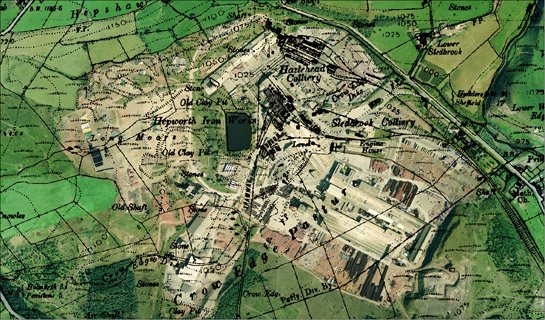
Figure 1: Aerial photograph of Hazlehead clay pits overlain by 1948 OS map, which shows Hazlehead and Sledbrook collieries and the Hepworth Iron Works.
Cities Revealed aerial photography © the GeoInformation Group, 2002; © and database right Crown Copyright and Landmark Information Group Ltd (All rights reserved 2008) Licence numbers 000394 and TP0024
Later Characteristics
The highly recent nature of the areas within this zone means that there has been little opportunity for later additions to the landscape. The former collieries within the zone are moving towards ‘Post Industrial’ landscapes, with the reclamation of spoil heaps, planting of trees and addition of new roads to facilitate the creation of business parks. The 1990s has been a time of significant change for former extractive sites, with financial support coming into the region for regeneration of such areas, for example from European Objective 1 funding. This has meant that the vast majority of former collieries now fall within the ‘Post Industrial’ zone.
Opencast coal mining is an ongoing process in the district, although not on the scale it once was. This type of landscape will rapidly move away from active extraction, like the former collieries. At ‘Wombwell Opencast’ large areas of the site that were still being opencast in 2003 have already been landscaped and are being developed as a community green space (South Yorkshire Forest 2007).
Character Areas within this Zone
Map links will open in a new window.
- Ardsley Clay Pits (Map)
- Cawthorne Clay Pits (Map)
- Grimethorpe Collieries (Map)
- Hazel Head Works (Map)
- Monckton Colliery and Royston Drift (Map)
- Stairfoot Brickworks (Map)
- Wombwell Opencast (Map)
Bibliography
- Banks Group/ Hepworth Building Products Ltd
- 1999 Hazlehead Reclamation: Environmental Impact Assessment [unpublished].
- Gray, G.D.B.
- 1976 The South Yorkshire Coalfield. In: J. Benson and R.G. Neville (eds.), Studies in the Yorkshire Coal Industry. Manchester University Press, 31-44.
- Hill, A.
- 2002 The South Yorkshire Coalfield: a History and Development. Stroud: Tempus Publishing Ltd.
- Raistrick, A.
- 1973 Industrial Archaeology. London: Grafton Books.
- South Yorkshire Forest
- 2007 Barnsley residents Look Forward to Healthy Green Space. South Yorkshire Forest News (Summer 2007) [online]. Available From: www.syforest.co.uk/downloads/syf_news_summer_2007.pdf [accessed 05/03/08].