19th to Early 20th Century Villa Suburbs
Summary of Dominant Character
This zone is characterised by the development of housing for purchase by the middle classes. These properties were built as semi-detached or detached houses and display less uniformity than those built either in the ‘Grid Iron Terraced Housing’ or ‘Early to Mid 20th Century Private Suburbs’ character zones. Most properties generally afford some level of garden to both the front and rear of the property, the gardens generally aspiring to some degree of landscaping. Streets are often lined with trees and building densities are generally low. The majority of the properties in this zone were developed from the late 19th century to around 1930.
The areas that make up this zone were first developed in the 19th century as middle class suburban developments away from the industry south of Barnsley town centre, which was becoming increasingly densely developed with back to back and courtyard housing (Taylor 1996, 117).
There are significant numbers of mature trees (in both streets and private gardens) and evergreen shrubbery that contribute to a Gardenesque atmosphere, clearly differentiating these areas from the terraced housing areas and younger middle class suburbs surrounding them.
The streets closest to Barnsley town centre were built up in the late 19th century and streets were then laid out further to the north, either side of Huddersfield road. This area took much longer to develop, which has led to a complex mix of building styles in an area where the main character is that of the original streets and villas. This is likely to have been the result of division of the land by a land or building society. Land societies bought up whole estates and divided them into individual building plots; members of the society paid a monthly contribution to costs and charges for making roads, with the society being wound up once costs for the land had been met. These types of land society were popular because they enabled larger numbers of people to vote, as voting rights were linked to property ownership (Harman and Minnis 2004, 282). The slow development of housing in parts of ‘Churchfields’ may be an indication of land bought to obtain voting privileges but not built upon. Locally, the Barnsley British Co-operative Society was developing houses between 1862 and 1902 (Barnsley Family History Society 1999 [accessed 21/1/08]) and may have played a part in the establishment of these villa suburbs.
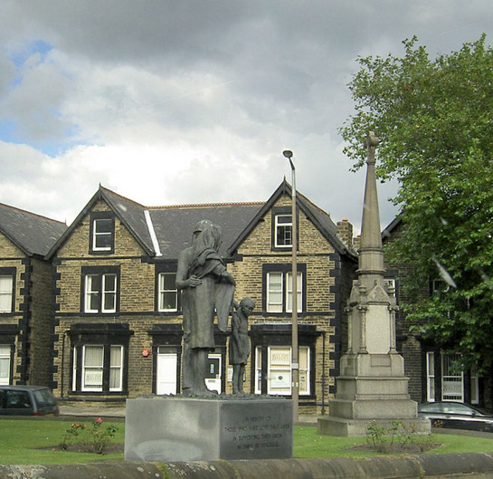
Figure 1: Victoria Road, Churchfields, Barnsley.
© Steve Fareham – licensed under Creative Commons license (http://creativecommons.org/licenses/by-sa/2.0/)
Relationships with Adjacent Character Zones
The villa suburbs of Barnsley are located close to the town centre and the town has grown around them. ‘Dodworth Road Villas’ became surrounded by denser terraced housing and industrial developments in the early 20th century, which probably stunted any further development of villa houses in this small area. ‘Churchfields’ expanded, but has since been surrounded by 20th century housing developments.
The development of land societies that influenced housing within this zone also affected an area within the ‘Municipal Housing’ zone. The Honeywell estate is built on land that was initially intended to be part of the Honeywell Mount Freehold Land Society, established in 1873 (May 2004, 7). Few plots were built upon and this land was eventually turned over to council housing development in the mid 20th century. The low uptake of the plots may have been due to the continued use of New Gawber Colliery, which was located near to the prospective development.
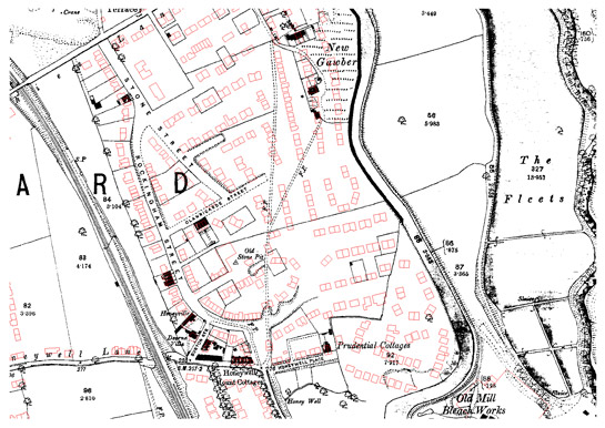
Figure 2: Honeywell estate in Barnsley. The streets associated with the Honeywell Mount Freehold Land Society are shown under development but few houses have been built within the plots. The red outlines show the eventual modern development of a council estate on the site in the mid 20th century.
1893 OS map © and database right Crown Copyright and Landmark Information Group Ltd (All rights reserved 2008) Licence numbers 000394 and TP0024
Inherited Character
The middle class developments of Barnsley were built at a time when the growth of the linen industry was allowing the town to expand rapidly across the enclosed land surrounding the previously small market town. To the north of the town this land was former open fields, many of which had been enclosed by the 1779 Barnsley Enclosure Award (date from English 1985). The regular straight-sided enclosure of Church Field is named on Fairbanks 1777 enclosure map.
The regular pattern of these surveyed enclosures can be seen in the layout of the housing within this zone. Where the open fields were enclosed at an earlier date they often retained a pattern of narrow enclosed strips (see ‘Strip Enclosure’ zone). These are also visible in parts of the ‘Churchfields’ area.
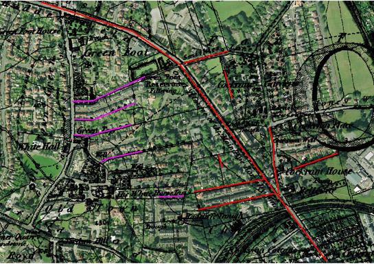
Figure 3: Well preserved field boundary patterns within the Churchfields villa suburb are shown in pink and red. Red lines represent areas of former surveyed enclosure and pink represents former strip enclosure boundaries.
Cities Revealed aerial photography © the GeoInformation Group, 2002 overlaid by 1855 OS map © and database right Crown Copyright and Landmark Information Group Ltd (All rights reserved 2008) Licence numbers 000394 and TP0024.
Later Characteristics
Because much of the villa suburbs that were laid out in the late 19th century were not fully built up, a range of housing styles have developed within this zone, as housing gradually filled the plots. These have, however, largely kept to a spacious design of detached and semi-detached houses, indicating a continuation of the middle class status of these suburbs.
Non-residential additions to the zone include annexes of Barnsley College. Many of these buildings date to the 1930s, but part of the main school building, off Hall Balk Lane, was built in 1909 as a Girls’ High School (English Heritage 2005, Listed Building No: 333725).
Character Areas within this Zone
Map links will open in a new window.
Bibliography
- Barnsley Family History Society
- 1999 Barnsley Family History Society [online]. Available from: http://www.barnsleyfhs.co.uk/barn1.htm [accessed 18/03/08].
- English, B.
- 1985 Yorkshire Enclosure Awards. Hull: University of Hull Department of Continuing Education.
- English Heritage
- 2005 Listed Building System Data [unpublished MIDAS dataset export in xml format]. Swindon: English Heritage National Monuments Record. Available from: National Monuments Record Centre, Kemble Drive, Swindon.
- Fairbank, W.
- 1777 A Map of the Township of Barnsley in the Parish of Silkstone. Available from: Barnsley Archives, Ref: EM/1953.
- Harman, R. and Minnis, J.
- 2004 Sheffield: Pevsner Architectural Guide. New Haven and London: Yale University Press.
- May, R.
- 2004 Archaeological Desk-Based Assessment of Canal Street, Barnsley, South Yorkshire [unpublished]. Sheffield: ARCUS.
- Taylor, H.
- 1996 Barnsley Comes of Age: The Town in the 1860s. In: B. Elliott (ed.), Aspects of Barnsley 4. Barnsley: Wharncliffe Publishing, 112-136.