Municipal Suburbs
Summary of Dominant Character
This zone is dominated by semi-detached houses and short terrace rows laid out in geometrical patterns, based on intersecting circles with open greens, institutional buildings and retail areas placed at the hubs of these radial streets. Cul-de-sacs are rare, with most roads forming circuits, and houses are generally aligned in a repetitive pattern, with small front and larger rear gardens. Public green spaces are generally simple areas of grass and there are few street trees included in the layout.
This housing estate style has much in common with the housing of the ‘Planned Industrial Settlements’ zone, as both were heavily influenced by the garden city designs of Ebenezer Howard. Howard was working in the late 19th and early 20th century, designing satellite settlements of low density houses with associated shops and recreational facilities (Edwards 1981, 83). Only two ‘Garden Cities’ were built, but the ideas were used in the development of suburban settlements, particularly those developed by municipal authorities.
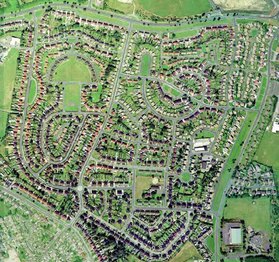
Figure 1: A curving road layout at New Lodge Estate.
Cities Revealed aerial photography © the GeoInformation Group, 2002
This style of development continued in a modified form into the mid and late 20th century in Barnsley. Later examples often followed the plan form layout of the earlier estates, but some, although geometrically planned, have less curving road patterns. The style of the houses also changed over time, with simpler buildings styles developing and more modern building materials being utilised.
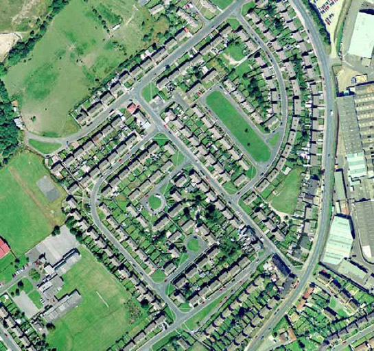
Figure 2: The more angular street layout at St Helen’s Estate.
Cities Revealed aerial photography © the GeoInformation Group, 2002
Another feature of late 20th century municipal housing is the establishment of low rise flats. These are generally a feature of the council estates closer to Barnsley town centre, but examples can be found in the wider suburbs. These flats consist of a mix of building styles, including large conjoined buildings, such as those at ‘Honeywell’, and smaller developments of just four residences, such as those on Sykes Street in ‘Kingstone Estate’. There is little private outside space in these developments, with simple grassed areas surrounding the flats. In contrast to the large numbers of high rise municipal developments in Sheffield, the only example of this type of housing within the district of Barnsley is found at ‘Sheffield Road Flats’.
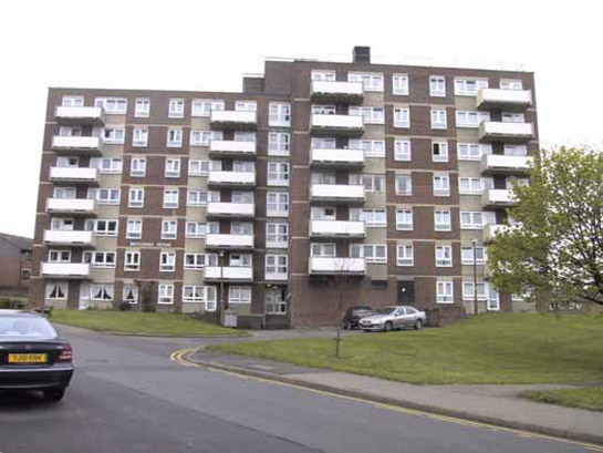
Figure 3: Sheffield Road Flats, Barnsley.
© Barnsley MBC
Until the late 19th century, house construction was the province of private individuals with land owners and industrialists responsible for most construction. From the 1840s onwards there were increasing concerns over the standards of housing for the poor (Havinden 1981, 417) and the beginnings of pressures for local authorities to intervene in matters of housing. There were, however, still large numbers within government who resisted these ideas.
The 1890 Housing of the Working Classes Act extended the interests of municipal bodies beyond just rebuilding, to the establishment of new estates (Gaskell 1976, 187). Municipal housing was often built away from existing urban centres as the Housing Act made it slow and expensive to buy up large areas of land for demolition and rebuilding (ibid, 188). In Bansley, 90% of the area covered by the Municipal Suburbs zone was enclosed land prior to this development. ‘Lundwood’ is one of the earliest such estates, built by 1906 OS mapping.
Although there was a growing recognition that state intervention was required to solve housing problems, it was not until after the First World War that centralised government subsidies were focused on home building. ‘Homes Fit for Heroes’ was a compelling slogan aimed at quelling public unrest by providing low density new houses for the expanding population (Short 1982, 31-2). Within Barnsley several estates had been built or were under construction by this point (see Figure 4 below).
The municipal housing schemes of the inter war years, however, failed to solve existing housing problems. This, alongside the hiatus in construction during the Second World War, an increase in population and war damage to existing housing, led to a severe shortage of houses (ibid, 42). In the 1950s and 60s significant numbers of council houses were built across the country and within Barnsley specifically. These houses were built in similar forms to the earlier estates but were often smaller and built to a poorer standard (ibid, 47).
Nationally there was a drop off in council building after the mid 1950s, as the government focused its attention on slum clearance rather than housing for the general population (ibid, 51). Within Barnsley, however, significant numbers of municipal houses continued to be built, as large numbers of high density, poor condition houses within the centre of the town were replaced.
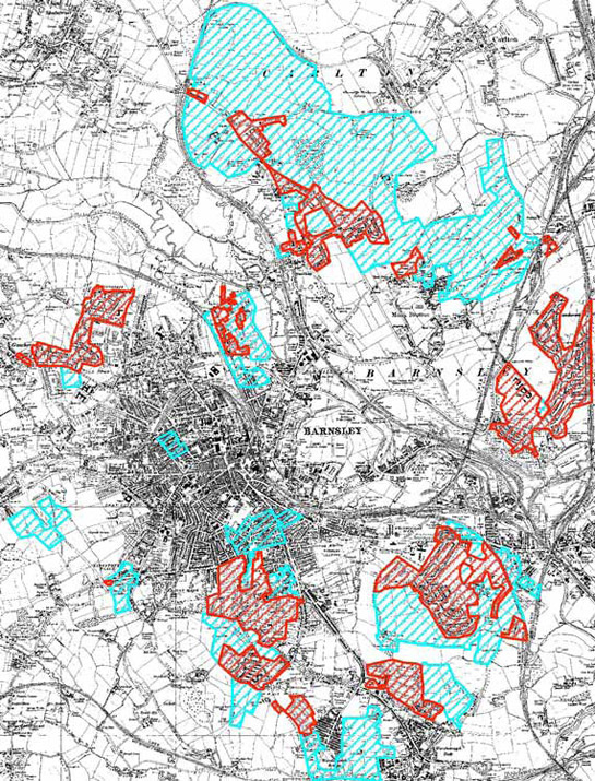
Figure 4: ‘Municipal Suburbs’ zone showing pre and post 1939 building. (Red = Municipal Suburbs built by 1939, Blue = Municpial Suburbs built after 1939)
Overlying 1938 OS map © and database right Crown Copyright and Landmark Information Group Ltd (All rights reserved 2008) Licence numbers 000394 and TP0024
Relationships with Adjacent Character Zones
The development of the ‘New Lodge and Smithies’ and ‘St Helen's’ suburbs had a close relationship with the then ongoing extractive industries around Barnsley. These extractive sites closed in the 1980s and 1990s and have since been subject to considerable alteration. The business parks and industrial parks that have grown up on these sites now fall within the ‘Post Industrial’ zone. Municipal housing in the south of Barnsley had links with the extractive industries along the Dearne Valley, particularly Barnsley Main Colliery, as well as with other industrial sites in Worsbrough Dale and around Stairfoot. Worsbrough Bridge, Worsbrough Dale and Stairfoot already had industrial settlements, prior to the establishment of the large municipal estates here; the council housing expanding these areas into suburbs of Barnsley.
As mentioned above, there is a connection between the ‘Planned Industrial Settlement’ zone and the ‘Municipal Suburbs’ zone. Many of the geometric cottage estates of the ‘Planned Industrial Settlement’ zone were built by the local council as part of the same housing improvement regime that saw the establishment of Barnsley’s municipal suburbs.
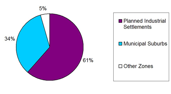
Figure 5: Chart showing which Character Zone land recorded by the HEC project as Planned Estate (Social Housing) falls within.
Inherited Character
There is little visible of the past landscape within the larger council developments around Barnsley. The scale of development that allowed for the establishment of large geometric estates mostly overwrote earlier field patterns. There are a few surviving boundaries on the edges of these estates, but often it is the main roads that are the main surviving feature of the former rural landscape. At ‘New Lodge and Smithies’, however, part of a farmstead, associated with an earlier elite residence, survives as a nursing home.
Closer into the town centre, the municipal estates have more complex histories. At ‘Honeywell’ the estate is built on land that was initially intended to be part of the Honeywell Mount Freehold Land Society, established in 1873 (May 2004, 7). Land societies bought up large areas and divided them into individual plots; members of the society paid a monthly contribution to costs and charges for making roads, with the society being wound up once costs for the land had been met. These types of land society were popular because they enabled larger numbers of people to vote - as voting rights were linked to property ownership (Harman and Minnis 2004, 282). Within ‘Honeywell’ few plots were actually built upon and this land was eventually turned over to council housing development in the mid 20th century. The low uptake of the plots may have been due to the continued use of New Gawber Colliery, which was located near to the prospective development and which has also now been over built by council housing.
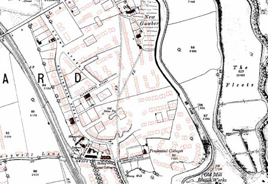
Figure 6: Honeywell Estate, Barnsley. The streets associated with the Honeywell Mount Freehold Land Society are under development by this time but few houses have been built within the plots. The red outlines show the eventual modern development of a council estate on the site in the mid 20th century.
1893 OS map © and database right Crown Copyright and Landmark Information Group Ltd (All rights reserved 2008) Licence numbers 000394 and TP0024; Modern mapping © Crown copyright. All rights reserved. Sheffield City Council 100018816. 2007
At ‘Summer Lane Estate’, ‘Kingstone Estate’, and ‘Worsbrough Common’ the municipal housing of the later 20th century replaced earlier residential development. There were large numbers of poor quality houses in central Barnsley; these areas were eventually cleared in the 1960s and were often then redeveloped for municipal housing.
Much of this earlier housing was related to the linen industry, which was primarily responsible for Barnsley’s rapid increase in population in the first half of the 19th century (Taylor 1993, 25). There were large numbers of weavers’ cottages south of the city centre, within the ‘Sheffield Road Street Flats’ character area and also at ‘Worsbrough Common’. These homes housed up to 6 looms per building and were built and owned by linen manufacturers for renting out to hand loom weavers. The looms were generally placed in a basement workshop, as the damp conditions made it less likely for the linen to snap during weaving (Taylor 1995, 42-3).
None of these weavers’ cottages survive and often the geometric arrangement of the municipal estate has over written the former street pattern. However, there are surviving fragments of earlier street patterns. The 19th century terraces and weavers’ cottages were often built on areas of former moorland that had been enclosed as part of the 1779 Barnsley Enclosure Award (date from English 1985). The surveyed enclosure field patterns became integrated into the layout of the 19th century housing developments and are sometimes the clearest evidence of the earlier landscape that have survived the demolition of the terraces.
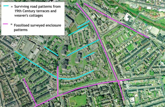
Figure 7: ‘Sheffield Road Flats’ Character Area showing preserved evidence of earlier landscapes.
Cities Revealed aerial photography © the GeoInformation Group, 2002
Later Characteristics
The 20th century saw large numbers of council homes built across the country, expanding existing settlements and replacing earlier low quality housing. 1954-5 was the peak for council house building and there followed a steady decline in the numbers of houses built (Short 1982, 52). This trend was to draw to a close in the later part of the 20th century, as council tenants were encouraged to buy their homes and there were fewer government incentives for councils to build housing (ibid, 59). A number of council houses in Barnsley moved into private hands in this time. This is part of a nationwide trend where home ownership has increased and council renting has decreased since the 1970s (Office for National Statistics 2004, 30).
This trend has led to more housing being built by private developers, which has itself led to the development of large late 20th century suburbs. Within the ‘Municipal Suburbs’ zone there has been some infilling by privately built housing, as well as expansion of private housing around them. Within ‘New Lodge and Smithies’ there are small areas of privately built housing that have replaced former council houses. This later redevelopment fits within the street pattern of the original estate.
Other later developments within this zone include improvements to green spaces and demolition of some housing to form further areas of green space – such as within the Kendray estates. Schools have also been improved and expanded over the years and a number of nursing homes have been established within the zone.
Character Areas within this Zone
Map links will open in a new window.
- Honeywell (Map)
- Kendray Estates (Map)
- Kingstone Estate (Map)
- Lundwood (Map)
- New Lodge and Smithies (Map)
- Sheffield Road Flats (Map)
- St Helen's (Map)
- Summer Lane Estate (Map)
- Wilthorpe (Map)
- Woodland Drive Social Housing (Map)
- Worsbrough Bridge Estates (Map)
- Worsbrough Common (Map)
- Worsbrough Dale Social Housing (Map)
Bibliography
- Edwards, A.M.
- 1981 The Designs of Suburbia. London: Pembridge Press.
- Gaskell, S.M.
- 1976 Sheffield City Council and the Development of Suburban Areas Prior to World War I. In: S. Pollard and C. Holmes (eds.), Essays in the Economic and Social History of South Yorkshire. Sheffield: South Yorkshire County Council, 187-202.
- Harman, R. and Minnis, J.
- 2004 Sheffield: Pevsner Architectural Guide. New Haven and London: Yale University Press.
- Havinden, M.
- 1981 The Model Village. In: G.E. Mingay (ed.), The Victorian Countryside, Volume II. London and Boston: Routledge & Kegan Paul, 414-427.
- Hey, D.
- 1981 Industrialised Villages. In: G.E. Mingay (ed.), The Victorian Countryside, Vol 1. London: Routledge and Kegan Paul, 353-362.
- May, R.
- 2004 Archaeological Desk-Based Assessment of Canal Street, Barnsley, South Yorkshire [unpublished]. Sheffield: ARCUS.
- Office for National Statistics
- 2004 Living in Britain: Results from the 2002 General Household Survey [online]. The Office for National Statistics. Available from: www.statistics.gov.uk/lib2002/ [accessed 01/04/08].
- Short, J.R.
- 1982 Housing in Britain: The Post War Experience. London and New York: Methuen.
- Taylor, H.
- 1993 Bleachworks of Barnsley and their Industrial Archaeology. In: B. Elliott (ed.), Aspects of Barnsley. Barnsley: Wharncliffe Publishing, 25-61.
- Taylor, H.
- 1995 Taylor Row and the Handloom Weavers of Barnsley. In: B. Elliott (ed.), Aspects of Barnsley 3. Barnsley: Wharncliffe Publishing, 39-64.