Industrial
Summary of Dominant Character
This zone is made up of areas where large scale industrial activities, principally the production of steel and its processing by casting, forging and rolling, still form a dominant influence on the built environment. Much of the character areas to be discussed here are to be found located on the alluvial flood plains of river valleys. As well as being a location traditionally associated with the metal trades due to the location of water powered industries, these valley floors provided significant areas of level ground, an essential component of the spatial organisation of large complexes.
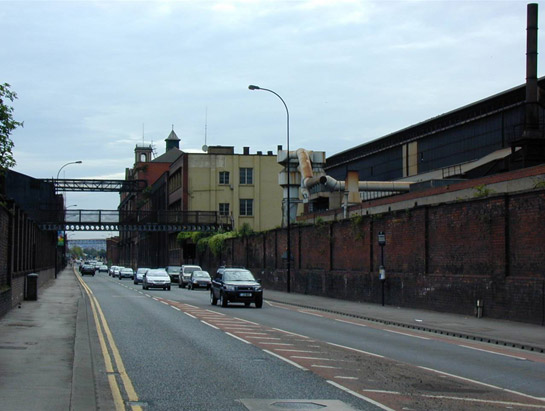
Figure 1: The ‘River Don Works’ of Sheffield Forgemasters straddles Brightside Road and represents one of the last working survivals of a large scale steel works established in the late 19th century.
©2006 SYAS
From the mid 19th century onwards Sheffield’s heavy trades of steel making and processing began to outgrow the traditional workshop based sites of the ‘18th-19th century Industrial Grids’ zone. This development was largely the result of technological advances in steel-making and transport and was driven by, and helped to develop further, the growth in national and international demand for railway products, ship-building, construction materials and engineering castings. From the 1860s onwards much of the expansion of the Sheffield steel industry was driven by a concomitant development in the technological sophistication and increases in the scale of the armaments industry. Sheffield’s industries particularly focussed on the production of shell casings, guns to deliver these shells and amour plate intended to resist similar projectiles (Hey 1998, 154).
A characteristic of the development of heavy industry is one of continual re-investment in plant and machinery, with the result that the present complexes in this zone are often the result of many phases of renewal, expansion and rebuilding.
Typical forms within this zone are industrial complexes of large sheds with wide roof spans, built to accommodate a range of processes, and often forming linear complexes (reflecting the flow of work along a production line). Building materials have changed through time, with early examples being brick-built and later ones being steel framed sheds clad in corrugated steel sheet materials. Roof lines are frequently punctuated with chimneys, ventilation louvres and extraction vents. Most of the character areas in this zone are (or were) provided with railway links, in order to facilitate the supply of raw materials and the delivery of products to their markets.
The zone represents a dramatic change of scale when compared with the smaller urban industries from which they developed1. Production of steel in Sheffield up to the mid 18th century had involved two main processes; the conversion of Swedish pig iron to blister steel in cementation furnaces, and its further refining in crucible furnaces. The landscapes associated with these earlier processes were most often based around courtyard plans (see the 18th – 19th century Industrial Grid zone), with movement between different processes across a shared central courtyard. These buildings were generally narrow by later standards (allowing for natural light to illuminate working areas). The later bulk processes demanded bigger covered working spaces, themselves made possible by larger rolled products that enabled wider roof spans to be constructed using fireproof steel beams. “[T]he building became simply a shell that sheltered a processing area…” (Wray et al 2001) with the covered open space facilitating the movement of large castings around the working area by cranes.
To the north of the River Don, the ‘Saville Street to Attercliffe’ character area largely developed from the mid 19th century onwards. This character area is marked by smaller scale development than the other character areas within this zone. As a result there is more variety in the styles, ages and ownership of buildings in this area. Despite heavy post-war investment in new industrial buildings, the original industrial development is still clearly visible, particularly in the street pattern and where early buildings, such as the Canal Street Works, survive.
The remaining three character areas are the product of much larger consolidated industrial concerns. ‘Stocksbridge Don Valley’ character area is dominated by Stocksbridge Works (founded as Samuel Fox and Co. in 1842), which is currently owned in its entirety by the Corus Group. ‘Shepcote Lane’ character area includes the massive integrated steelworks of Outo Kumpo PLC, as well as surviving buildings of the Imperial Steelworks of the former Edgar Allen Company, and the smaller works of Tinsley Wire Industries Ltd. ‘River Don Works’ is made up of present and former buildings of Sheffield Forgemasters International Ltd, based on the site of the east end works established by the Vickers company in 1864. These industrial complexes, which have come under repeated threat over recent decades due to continual fluctuations in the global price of steel and the ownership structure of businesses, are generally of a variety of dates, reflecting many stages of modification. Large corrugated sheds are a common theme, although most include earlier brick-built (or, in the case of Stocksbridge, stone-built) phases.
Inherited Character
Prior to its industrial development, much of the land within this zone was marked by the Ordnance Survey as liable to flooding. The characterisation project has generally interpreted the medieval land-use of these areas as ‘valley floor meadow’, an interpretation based on their location alongside the rivers Don and Rother. Historically these meadows are likely to have been managed as wet meadowland – with grasses cut for hay late in the summer, when conditions were suitable. In wetter years, when the hay could not be successfully harvested, the land would be grazed. Where it survived into the 19th century, much agricultural land along the valley floors shows signs of drainage and improvement, as well as straight boundaries often indicative of parliamentary enclosure of former common land. This may suggest that in South Yorkshire meadowland was generally held and operated in common. Within this zone, later industrial development has generally not fossilised any legibility of this earlier meadowland landscape, or its later rationalisation by 18th and 19th century enclosure acts.
Of equal importance to the economic exploitation of the valley floors was the growth in the use of water power from the medieval period onwards. Along the course of the river Don a number of features associated with water management are retained. These include weirs, goits, culverts, dams and other features of the systems developed to harness the energy of the rivers. Until the late 19th century, water power continued to be utilised along the Don for forging or grinding of edge tools (see Crossley et al 1989 and Miller 1949 for site by site accounts).
Within this zone three sites seem to have directly influenced the siting and development of later heavy industries. The industrial complexes at Stocksbridge Works, Royds Mills (Thessco), and Attercliffe Steel Works (Stevenson / Newhall Road) all evolved directly from water-powered sites with early post-medieval origins. At most of these sites, industrial expansion has removed visible traces of the water-powered sites, except on the banks and bed of the river itself - where a number of weirs and goit culverts can still be seen. However, at Attercliffe Steel Works a lengthy open goit survives, cutting off an area of scrubland between it and the river. The later development of Attercliffe Steel Works has also fossilised the outline of the former mill dam in the form of an open courtyard surrounded by buildings originally built around the dam in the early 20th century.
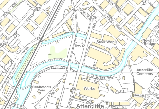
Figure 2: Attercliffe Steel Works, showing the open head goit for the former water-powered wheel (to the left of Stevenson Road) and the site of the former dam – an open courtyard surrounded by buildings (to the right of Stevenson Road).
© Crown Copyright, All Rights Reserved, Sheffield City Council 100018816. 2008
Crucial to the development of the heavy industries of the east end was the introduction of means of bulk transport. Prior to the 19th century, the only means to import materials into and products out of Sheffield was by road transport. This limiting factor to the growth of the industries of the town began to be overcome in the 18th century with the development of first the turnpike network (see Smith 1997), and the progressive extension of the navigable limits of the River Don; the new channels of the South Yorkshire Navigation reached Tinsley Wharf by 1751 (Hey 1998, 108). The extension of water navigation to the city centre by the construction of the Sheffield Canal, by 1819, enabled the transition from predominantly urban light production, to out of town bulk production. Within 4 years of the canal’s completion this industrial expansion was initiated by the construction of William Greaves’ Sheaf Works, one of the world’s first integrated steam powered steel cutlery works (Harman and Minnis 2004, 158). The canal remains significantly legible along its length.
Later Characteristics
Later landscapes in this zone are largely the result of the clearance or replacement of earlier industrial buildings. A notable 21st century intrusion to the Saville Street to Attercliffe character area was the construction of the Bernard Road Incinerator. Major parts of both Corus’s Stocksbridge and Outo Kumpo’s Shepcote Lane facilities have closed since 2000, including the arc-melting shop at Stocksbridge (ending a 150 year tradition of primary steel making at the site) and the cold rolling mills at Shepcote Lane. The Stocksbridge site is currently subject to plans for mixed-use redevelopment.
The zone is closely related to the ‘Post Industrial’ zone – much of which has developed its present character as a result of the regeneration of sites previously occupied by 19th and 20th century heavy industries. As a result there is considerable overlap in character between these two related zones. Characteristics of 19th and 20th century heavy industrial development form the dominant legible character of the ‘Post Industrial’ zone, whilst recent developments in character areas still dominated by heavy industry is tending towards post industrial development.
Character Areas within this Zone
Map links will open in a new window.
- Ecclesfield Common and Blackburn Brook Valley (Map)
- Parkwood (Map)
- River Don Works (Map)
- Saville Street to Attercliffe (Map)
- Shepcote Lane (Northern) (Map)
- Stocksbridge Don Valley (Map)
Bibliography
- Crossley, D. (ed) with, Cass J., Flavell, N. and Turner, C.
- 1989 Water Power on the Sheffield Rivers. Sheffield: Sheffield Trades Historical Society with University of Sheffield Division of Continuing Education.
- Harman, R. and Minnis, J.
- 2004 Sheffield: Pevsner Architectural Guide. New Haven and London: Yale University Press.
- Hey, D.
- 1998 A History of Sheffield. Leicester: Carnegie Publishing Ltd.
- Miller, W.T
- 1949 The Water Mills of Sheffield (Fourth edition). Sheffield: Sheffield Trades Historical Society.
- Smith, H.
- 1997 Sheffield’s Turnpike Roads. In: M. Jones(ed.), Aspects of Sheffield. Barnsley: Wharncliffe Publishing Ltd.
- Williams, A.
- 2003 The Typology of Industrial Buildings with Reference to the Steel Trades in Sheffield, 1750-1900. Thesis (PhD). University of Sheffield.
- Wray, N., Hawkins, B. and Giles, C.
- 2001 One Great Workshop: The Buildings of the Sheffield Metal Trades. London: English Heritage.
1A full account of typological stages in the development of industrial architecture in the Sheffield steel industry has recently been made by Alan Williams (2003)