Early to Mid 20th Century Private Suburbs
Summary of Dominant Character
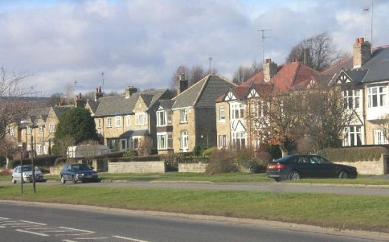
Figure 1: Abbey Lane, Sheffield.
© Andrew Loughran. Licensed for reuse under a creative Commons License http://creativecommons.org/licenses/by-sa/2.0/
This zone is characterised by large areas of housing developed speculatively between 1914 and 1945, often in estates, but also includes some areas of later infill, where later housing has been developed within earlier suburbs. These developments have much in common with areas developed in the ‘Early to Mid 20th Century Municipal Suburbs’ zone. The architectural and urban plan form of both zones developed from earlier conceptions of the garden suburb. Housing areas are generally made up of estates (generally smaller than those found in municipal areas of similar date) on which semi-detached and detached housing of similar style can be found. The estates within these groups were not, as a rule, built to a wholesale plan and as a result many different phases of piecemeal development and areas of pre-existing older landscapes are often legible within them. This is especially true on the boundaries between developments and at the sites of earlier settlement. Housing development is generally of a medium density.
The areas making up this zone are all to be found on the western and southern fringes of the city, with most being in close proximity to open landscapes of the city’s ‘Sub-Rural Fringe’ zone, providing access to a number of facilities developed in parallel to housing within this zone, such as golf clubs, playing fields and parkland. The zone is well provided for with primary and secondary schools, built at a range of dates through the twentieth century. Industrial landscapes are almost completely absent from this zone, which continues the traditions of 19th century villa suburbs in providing a landscape separated from the world of work.
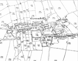
Figure 2: Greenhill Village in the 1890s. The village is typical of small nucleated villages, displaying a simple planned layout based on narrow crofts perpendicular to a main street at the heart of an open field system.
© and database right Crown Copyright and Landmark Information Group Ltd (All rights reserved 2008) Licence numbers 000394 and TP0024
Inherited Character
This zone has absorbed at least three historic settlements; Greenhill, Norton Lees and Wadsley. Wadsley and Norton Lees appear on mid 19th century mapping as simple irregular small hamlets. However, some attributes of the plan form of Greenhill, still legible today, suggest that this village had at least some elements of planning involved in its layout. The village appears on historic maps as a linear settlement at the centre of an extensive open field system, most of which had been enclosed into semi regular strips by the mid 19th century. Narrow residential property divisions are laid out along this main street, with each plot afforded some frontage to the main street. This pattern of settlement is typical of villages and towns that were replanned in the medieval period (Aston 1985, 72). A number of these boundaries survive along Greenhill Main Street and the historic core area includes 10 listed buildings dating from the 16th – 19th centuries, including timber framed buildings. The village street (Main Street) retains much of the winding character of a medieval street, with a decidedly uneven width and irregular building lines despite later influences.
Wadsley and Norton Lees do not appear to display signs of medieval planning, but instead probably have their origins as small hamlets. Both include important survivals of vernacular architecture, especially the outstanding Bishop’s House at Norton Lees – a ‘post and truss house’ dating to c.1500. At Wadsley, significant investment in buildings seems to have been made during the mid 19th century and a fine complex of institutional buildings from this period survives on Worrall Road, including a church, school room and almshouses.
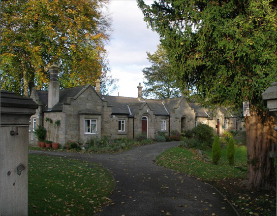
Figure 3: These Almshouses form part of an early-mid 19th century institutional landscape at Worrall Road, Wadsley.
Photo © SYAS 2005
The suburbanisation of this zone resulted in the loss of three types of former field pattern. Much of this zone was characterised until its suburbanisation by piecemeal enclosure patterns, probably relating to the clearance of woodland in the medieval period or earlier. Fragments of these ancient woods survive in close association with this zone, in the ‘Sub-Rural Fringe’ zone – at ‘Abbeydale and Millhouses’ and ‘Norton Village and Parklands’ character areas, on steeply sloping escarpments and sites preserved within parks. The second type of field pattern existed only around the village of Greenhill – the only part of this zone to be built across a clearly discernable open townfield system. This type of landscape emerged as a result of the enclosure of adjacent or individual strips within a formerly open ‘common’ arable field.
Unfortunately few discernable landscape traces of either of these types of field systems are clearly legible within this zone, with only fragments visible occasionally at the edges of developments - for instance, the boundaries of Downing and Glenview Road, which were fitted into surviving former strip fields to the north of Greenhill. Despite the widespread destruction of earlier field patterns, as in other zones historic road patterns have proved to be a longer lasting feature of the landscape. The ‘Ecclesall and Whirlow’ character area in particular exemplifies this pattern, with a complex network of interconnecting lanes surviving into the present day. Of these, Millhouses Lane, parts of Carter Knowle Road, Archer Lane, Button Hill Lane, High Storrs Road, and High Lane (formerly Dead Lane) almost certainly pre-date the Parliamentary Award for Ecclesall of 1781.
The third type of enclosure pattern to have formerly existed in this zone resulted from parliamentary enclosure of large areas of common moorlands on higher ground, to the west of Sheffield, and smaller areas of common grazing, often found at the junctions of tracks leading out towards the moors, as well as on steep sloping sandstone escarpments. The enclosure of these commons produced a newly ‘commodified’ class of land that could be readily traded by its owners. The frequently marginal quality of the land in agricultural terms probably encouraged its sale for building – often the first residential developments in this zone are to be found on such areas. An example of this is at Carter Knowle, where a triangular former common is shown on the 1788 Ecclesall Enclosure plan as set aside for the building of a new chapel (now the church of All Saints, first built in 1789 and remodelled in 1843 (Hunter 1869, 349)).
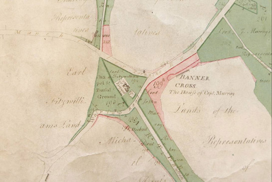
Figure 4: Extract from W Fairbank’s ‘Plan of the Ecclesall Enclosure Award’ of 1788 (Sheffield Archives CA 363) shows the enclosure of common lands (shaded green) at Carter Knoll. Here former common land was set aside for the construction of a new Chapel and Burial Ground
photograph © SYAS courtesy of Sheffield Archives. Used by permission.
Another example is seen at Loxley, where part of the former common around the junction of Loxley Road and Rodney Hill was developed progressively for housing after the 1805 enclosure award.
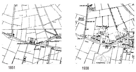
Figure 5: Comparison of these extracts of historic OS mapping shows how early twentieth century suburbanisation subdivided and fossilised straight sided enclosures first defined by surveyors of the Parliamentary Enclosure Award.
© and database right Crown Copyright and Landmark Information Group Ltd (All rights reserved 2008) Licence numbers 000394 and TP0024
Later Characteristics
Whilst some estates in this zone represented wholesale redevelopment (for instance much of Norton Lees was built as a single estate by the Arnold Laver company), by the start of World War II there was still much space within and on the fringes of most of these areas awaiting development. These spaces have been progressively developed during the later 20th century, mostly for further housing by speculative developers. Prior to the mid 1970s, these infill developments included some system built municipal schools and housing developments and tended to follow established patterns of development, on curving geometric through roads. In the late 20th century, new development began to increasingly follow cul-de-sac and sinuous road patterns, where individual houses do not face directly across the street at one another.
Most recently there has been a trend within this zone for the redevelopment of land for new housing. Former institutional buildings are particularly vulnerable to this trend, across Sheffield, as large establishments, originally dating to the late 19th and early 20th centuries, fell into disuse and disrepair in the late 20th century. Examples in this zone include the sites of Lodge Moor and Middlewood Hospitals, established as hospitals in 1888 and 1878 respectively. Both closed during the 1990s and both have been redeveloped for housing since 1999, with significant demolitions of the majority of the former hospital buildings. At both sites perimeter walls and the main administration buildings have been retained.
Character Areas within this Zone
Map links will open in a new window.
- Crosspool and Fulwood (Map)
- Ecclesall and Whirlow (Map)
- Greenhill, Beauchief and Norton Suburbs (Map)
- Norton Lees (Map)
- Wadsley (Map)
Bibliography
- Aston, M.
- 1985 Interpreting the Landscape: Landscape Archaeology and local History. London and New York: Routledge.
- Fairbank, W.
- 1788 Map or Plan of the Ecclesall Enclosure Award. Sheffield Archives ref CA 363.
- Hunter, J.
- 1869 Hallamshire: The History and Topography of the Parish of Sheffield…” Sheffield: Pawson and Brailsford.