Late 20th Century Private Suburbs
Summary of Dominant Character
This zone represents the expansion of the suburban city, explicitly planned by the city council in the 1960s, into parts of former Derbyshire between the historic settlements of Mosborough, Beighton, Hackenthorpe and the Rother valley. The settlements founded: Waterthorpe, Owlthorpe, Southall, Westfield, Oxclose and Halfway, are known collectively as the ‘Mosborough Townships’. In terms of urban planning they borrow much from the ideas of other new towns of the same period, such as Peterborough, Milton Keynes and Warrington. Early plans for these developments show that the new realities of rising car ownership were at the centre of the way the developments were envisioned. The townships had a cellular plan (each approx 1km sq), each with its own local centre with shops, a school and community facilities, with the township edges marked by ‘parkway’ roads running through open spaces and forming the overall large grid into which the developments fitted (Hey 1998, 233).
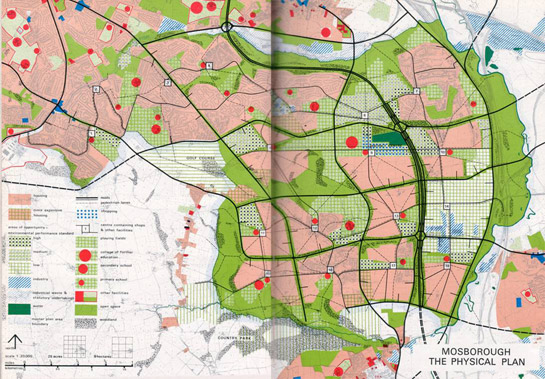
Figure 1: Masterplan for Mosborough Townships, 1967. The ‘new town’ area is to the bottom right. Here each township was designed to have its own central facilities; roads linking the townships were designed to define each local unit.
© SYAS
The realisation of this masterplan would take somewhere approaching 20 years, with some progress made with the construction of Halfway, Westfield and Waterthorpe townships by the late 1970s, principally by the construction of social housing. Infilling of remaining areas continued throughout the 1980s and 1990s. As a result of government policies, after 1980 most housing was developed speculatively. Industrial and commercial areas have both been provided within this zone, with industrial estates at Holbrook and Oxclose and commercial, retail and leisure developments at Crystal Peaks and Drakehouse. These latter developments are typical of late twentieth century retail complexes, featuring integral transport nodes, large car parks, and modern utilitarian buildings designed to maximise and combine storage and retail floor space.
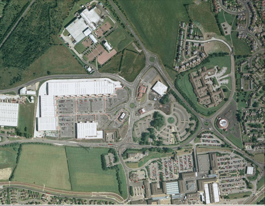
Figure 2: The massive developments of Crystal Peaks and Drakehouse are typical of late 20th century centralised retail, with their use of large prefabricated warehouse buildings, dedicated transport nodes, and their enormous car parks.
Aerial Photograph © 1999 Geoinformation Group.
Private housing developments, which constitute the bulk of the stock built from 1980 onwards in this zone, are based on interwoven cul-de-sacs, featuring a variety of detached and semi-detached housing plans. Both housing and road patterns are designed to minimise through traffic past the frontages of houses, whilst ensuring that each property has some form of vehicular access. As a result, properties do not generally front on to main roads, but are instead clustered around short branching cul-de-sacs.
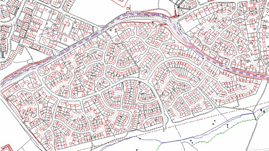
Figure 3: Example of 1980s cul-de-sac development in Hackenthorpe. Houses are set away from major roads on short curving cul-de-sacs.
Mapping © Crown copyright. All rights reserved. Sheffield City Council 100018816. 2007
Inherited Character
The historic character of this area is not on the whole older than the late 20th century, although surviving older settlements and some former strip field countryside in the Moss valley, to the west, closely surround it. Historically this area was characterised by open field agriculture – large areas of arable field and grazing land were still apparently held in common by the time of the Parliamentary Enclosure of the historic parish of Eckington (in which much of this zone lay) in 1796 (Stroud 1996, fig 385). The communities responsible for farming this landscape lived mostly outside this zone, in the nucleated and semi-planned villages of Beighton and Mosborough. The village of Hackenthorpe is the only pre-existing nucleated village to lie entirely within this zone, although the majority of the traditional buildings along its Main Street were demolished in the late 1980s and 1990s and replaced with new estate housing. The most legible part of this former village is a collection of late 19th century buildings around Sheffield Road that cluster around a possible former village green. Fragments of enclosure boundaries (mostly dating to the parliamentary division of the former common land) are preserved across the later phases of the townships, often forming the subdivisions into which culs-de-sac have been inserted.
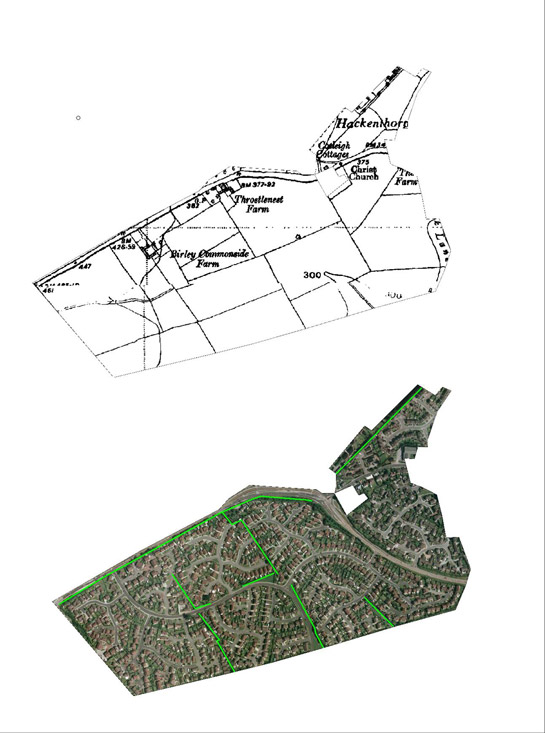
Figure 4: In this unit of the Mosborough Townships to the south of Hackenthorpe, development of cul-de-sac housing has retained fragmentary legibility of earlier surveyed boundaries, dating to the 1796 Eckington Parliamentary Award.
(Historic Map Extract © and database right Crown Copyright and Landmark Information Group Ltd (All rights reserved 2008) Licence numbers 000394 and TP0024; Cities Revealed aerial photography © the GeoInformation Group, 2002
Later Characteristics
The main period of development in this zone stretches from the 1960s to the time of the characterisation study and, as a result, the dominant characteristics of this area are, at the time of this study, continuing to form.
Character Areas within this Zone
Map links will open in a new window.
- Mosbrough Townships (Map)
Bibliography
- Hey, D.
- 1998 A History of Sheffield. Lancaster: Carnegie Publishing
- Stroud, G.
- 1996 The Value of the Fairbank Collection as a Resource for the Study of Landscape Change in the Parish of Eckington, Derbyshire. Dissertation (MA). University of Sheffield.