19th to Early 20th Century Villa Suburbs
Summary of Dominant Character
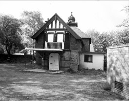
Figure 1: The tiny Lantern Theatre, built by cutlery manufacturer William Webster in the grounds of his house on Kenwood Park Road
© SCC UDC
The character areas that make up this zone were first developed in the 19th century as middle class suburban developments away from the industrial and commercial city centre, which at that time was becoming increasingly densely developed with back to back and courtyard housing. The predominant building types range from detached mansions to large semi-detached houses, normally featuring generous private gardens or (around the larger mansions) small parks and other designed grounds. The majority of buildings in these areas are built of stone with a mixture of Tudor, Classical and Gothic architectural styles generally employed. Larger residences can include such high status elaborations as libraries, ballrooms, conservatories or even (in Nether Edge’s Kenwood Park Road) a private theatre.
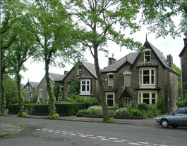
Figure 2: A group of mid C19 stone-built villas, typical of this zone, set back from a tree lined avenue in the ‘Nether Edge’ Character Group
© SCC UDC
The streets have largely remained free from large areas of later terraced infilling, although this type exists to some extent in most character areas, as do pockets of mid 20th century semi-detached infill. Significant plantings of mature trees (in both streets and private gardens) and evergreen shrubbery contribute to a ‘Gardenesque’ atmosphere, clearly differentiating these areas from the terraced housing areas and later middle class suburbs surrounding them. In larger scale planned developments, such as Kenwood, Broomhall and Endcliffe Crescent, surveyors and landscape gardeners were employed to design the curvilinear road networks so as “to create constantly changing vistas of the picturesque “villa” residences emerging from their leafy surroundings” (Doe 1976, 177).
Public open spaces tend to be less common in this zone than in either 19th century terraced or later 20th century municipally developed suburbs. In contrast to those zones, most residences are provided with some level of private ornamental space. Sports clubs, where they exist, tend to be private developments rather than being accessible to the general public. Industrial land uses are generally absent but institutional buildings are a feature – especially in the Broomhall and Nether Edge character areas, where various departments of Sheffield Hallam University have colonised earlier buildings.
Broomspring and Broomhall character areas: The earliest phases of these developments are to be found around Glossop Road in the districts of Hanover and Broomhill. Developed from the 1820s onwards (Harman and Minnis, 2004, 247) by a variety of landowners, development included many large villas as well as more modest housing. Patterns of development in these areas tended to follow long established traditions of land subdivision; regular straight-sided enclosure and strict building lines are the norm in these areas. This regular subdivision of land produced grid iron street patterns, particularly between Broomspring Lane and Glossop Road where larger examples of terraced housing dating from before the 1864 bylaws have survived the widespread demolition of their back-to-back counterparts due to their grander proportions.
From around 1840 (Doe 1976, 177), the owner of the Broomhall Estate, John Watson, sponsored the development of a new housing development based around Collegiate Crescent, a grand sweeping road lined with trees around which were laid out generous plots for villas - themselves approached by further curving driveways. Gates controlled entrance and access to the estate until their removal in 1916 (Harman and Minnis 2004, 256).
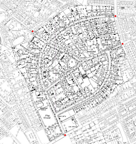
Figure 3: The Broomhall Park Estate in 1891. The layout of the estate was based upon ‘Picturesque’ principles to encourage a rural rather than an urban feel; the exclusivity of the surroundings was enhanced by the provision of gates and lodges at its entrances (marked by red dots).
Base map © and database right Crown Copyright and Landmark Information Group Ltd (All rights reserved 2008) Licence numbers 000394 and TP0024
Lodges built to oversee these gates survive on Park Lane, at either end of Collegiate Crescent and at the junction of Broomhall Road and Broomhall Place. The restrictive access to this new picturesque utopia was mirrored elsewhere in Broomhall - at the Botanical Gardens, opened by Sheffield Botanical and Horticultural Society in 1833, where access was only granted to shareholders and subscribers (ibid, 261).
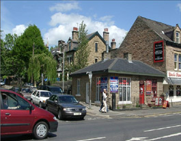
Figure 4: A former lodge (now reused as commercial premises) originally controlling access to the Broomhall Park Estate from Ecclesall Rd.
© SCC UDC
Nether Edge: The area now known as Nether Edge is bounded to the west (as the name suggests) by the dramatic escarpment of the Greenmoor or Brincliffe Edge sandstone (British Geological Survey Sheet 100 1974); elsewhere the land slopes gently eastwards. The first major developments stimulating the suburbanisation of the area were the construction of the Ecclesall Bierlow Union Workhouse on Union Road and the laying out of the Kenwood Park Estate around cutlery manufacturer George Wostenholme’s mansion, from 1844 onwards. The estate was designed for Wostenholme by garden designer Robert Marnock (also responsible for the Botanical Gardens), who laid out a series of curving avenues radiating from the main gate to Wostenholme’s mansion. Despite a greater level of later infilling than has occurred within the Broomhall Park Estate, the estate’s large stone villas and their gardens (often accessed through grand gateways), as well as the large numbers of street trees, means that the early picturesque character of this suburb is still instantly recognisable. The remainder of the 19th century saw the development of semi-detached housing to the east of the area by the speculative builder Thomas Steade and the establishment of varied villa housing to the west by the Montgomery Land Society. These developments employed grid iron street patterns, but still feature larger stone-built properties.
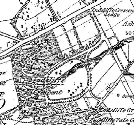
Figure 5: Endcliffe Crescent, Sheffield. OS mapping
© Crown Copyright and Landmark Information Group Ltd (All rights reserved 2008) Licence numbers 000394 and TP002
Ranmoor and Stumperlowe: The suburban development of this area was generally later than the other character areas within this zone, although at its core lies Endcliffe Crescent - an estate development of 1824 by the Endcliffe Building Company (Harman and Minnis 2004, 264), the earliest example of ‘picturesque’ suburban development in Sheffield. An interesting parallel with the development of the Broomhall Estate lies in the restriction of access to the development as a whole by the provision of a gate and (surviving) lodge at its entry from the north along Ranmoor Road.
Inherited Character
The land on which this zone was developed tended to lie away from historic nucleated settlements and the lower slopes of the river valleys. Indeed much of the attraction to the middle classes who sponsored their development was probably this detachment from the industrialised areas (and the concomitant smoke, noise, poverty stricken working classes and dirt) of the older settlements and the industrial valleys. As a result, older residential property boundaries and relict industrial sites tend to be extremely rare or even absent within this zone. Early maps (e.g. Fairbank 1795) show these areas as enclosed farmland characterised by a pattern of dispersed settlement. These earlier enclosure patterns are indicative of piecemeal enclosure processes, probably of medieval date, by the assartment of woodland. There were also small areas of common land, enclosed in typical geometric fashion by parliamentary awards at the turn of the 18th and 19th centuries.
In contrast to the generally poor survival of field boundaries, earlier medieval lanes (generally of irregular form) and later enclosure period roads (with their characteristic straight routes and standard widths) survive well, sometimes lined by original boundary walls.
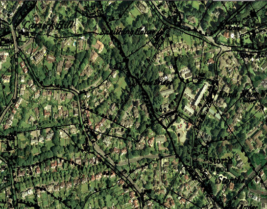
Figure 6: Overlay of the 1851 1:10560 OS map on modern aerial photography demonstrates little legibility of earlier field boundaries despite a well preserved earlier network of lanes (detail from Ranmoor and Stumperlowe character area).
Aerial Photography © 1999 Cities Revealed / Geoinformation Group Ltd. Mapping © Crown Copyright and Landmark Information Group Ltd (All rights reserved 2008) Licence numbers 000394 and TP0024
Broomspring and Broomhall character areas: Buildings earlier than the 1830s (when the planned estate of Broomhall began to be laid out) are rare. An exception to this is the original timber-built Broom Hall, which survives as the earliest phase of a later 18th century elite residence (Harman and Minnis 2004, 258). The timber-framed section is of post and truss construction and has been dated dendrochronologically to c.1498, with a further extension in c.1614 (ibid, 259).
Nether Edge: Little survives of the pre-suburban countryside, although Machon Bank and Cherry Tree Road fossilise the routes of earlier lanes that served the enclosed countryside depicted in the early 19th century. The recently closed Brincliffe Oaks Hotel on Nether Edge Road incorporates much of a post-medieval farmhouse.
Ranmoor and Stumperlowe: Buildings earlier than the 1830s (when the planned estate of Endcliffe Crescent began to be laid out) are rare.
Later Characteristics
Development trends over the 20th century have led to the continuing intensification of the building density within this zone, with areas of open land infilled up to the present day. Back land development, where the rear gardens of large properties are sold as development land, is a particularly obvious threat to the historic character of these areas. The proximity of the ‘Broomspring’ and ‘Broomhall’ character areas to campuses of the University of Sheffield and Sheffield Hallam University has led to a significant trend from the mid 20th century onwards of conversion of large residential properties to institutional use.
Character Areas within this Zone
Map links will open in a new window.
- Broomhall (Map)
- Broomspring (Map)
- Nether Edge (Map)
- Norfolk Park and City Road (Map)
- Ranmoor and Stumperlowe (Map)
Bibliography
- Doe, V.
- 1976 Some Developments in Middle Class Housing in Sheffield. In: S. Pollard and C. Holmes eds. Essays in the Economic and Social History of South Yorkshire. Barnsley: South Yorkshire County Council, Recreation Culture and Health Dept, 174-186.
- Cary, J. (engraver)
- 1795 A Map of the Parish of Sheffield in the County of York. 3¼ inches: 1 mile. Sheffield: Wm Fairbank and Son.
- Geological Survey of Great Britain
- 1974 Sheet 100 Sheffield– Solid and Drift, 1:50,000. Southampton: Ordnance Survey for the Institute of Geological Sciences.
- Harman, R. and Minnis, J.
- 2004 Sheffield: Pevsner Architectural Guide. New Haven and London: Yale University Press.