Late 20th Century Private Suburbs
Summary of Dominant Character
This zone represents suburban areas built by private developers since 1960. There is often significant divergence between the plan forms of municipal and private developments built during this period, with municipal housing developments showing a shift in emphasis from enclosed private gardens to unenclosed communal spaces. By contrast, private developments see a greater tendency towards the provision of lower housing densities. Cul-de-sac estates of detached housing are increasingly common, with all properties generally provided with vehicular access direct to integral off road parking spaces. Lower densities still, are provided in estates constructed of single storey and 1 ½ storey bungalows, which generally have larger building footprints than equivalent two storey houses.
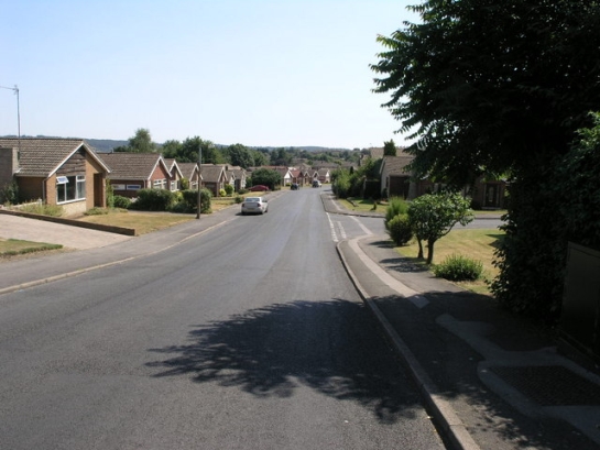
Figure 1: Sedgefield Way, Mexborough.
© 2006 Michael Patterson. Licensed for reuse under a creative commons licence- http://creativecommons.org/licenses/by-sa/2.0/
Private housing developments in this area tended initially (pre-1975) to develop the layout principles of earlier suburban housing, described in the ‘Late 19th to Early 20th Century Private Suburbs’ zone. Most such estates were developed with geometric land subdivision and with strong ‘garden suburb’ influences. From the 1970s onwards, however, the layout plans of private housing estates are more commonly of cul-de-sac form. These estates of interwoven branching road plans feature a variety of bungalow, detached and semi-detached housing. Housing and road patterns are designed so as to minimise through traffic past the frontages of the houses, whilst ensuring that each property has some form of vehicular access. As a result, properties do not generally front on to main roads, but are instead clustered around short branching culs-de-sac, increasing the privacy of each dwelling. An advantage of the cul-de-sac plan is its adaptability to irregularly shaped plots of land, making it especially suitable for plots available for infilling.
Public recreational spaces, where provided in this zone (c.5% of overall area) generally consist of recreation grounds rather than the more ornamental ‘parks’ more common to earlier periods. No woodland areas, either ‘ancient’ or ‘plantation’, large enough to have been characterised as units in their own right have been included within this zone.
Relationships to Adjacent Character Zones
This zone is almost always directly adjacent to earlier suburbanisation recorded in the ‘Early to Mid 20th Century Suburbs’ zones. This reflects a continuing 20th century trend towards the expansion of the suburban landscape. This suburban expansion was driven not just by the continued population growth of the borough1, but also by a general increase in prosperity resulting in the growth of property ownership and the consequent movement of population from the urban centres to lower density urban fringe locations.
The many areas making up this zone are fragmentary, occurring as suburban expansion into the countryside, as well as infilling open areas within earlier developments. Some areas of infilling in older suburbs are often too small to have registered as character areas in their own right and are included in other zones.
Inherited Character
The legibility of previous enclosure landscapes has generally been assessed as ‘invisible’, although as with other suburban areas, earlier roads passing through these developments have generally been retained, as have boundary patterns on the edges of development phases where earlier land parcels have formed the unit of development.
The majority of pre-1960 character units within this zone are areas of recreation grounds, allotments, schools and cemeteries originally developed on the fringes of earlier phases of suburbanisation (in the late 19th-early 20th centuries). These have continued to be used by residents of the later suburbs.
Later Characteristics
The main period of historic character development in this zone stretches from the 1960s to the time of the characterisation survey and, as a result, the dominant characteristics of this zone are continuing to form.
Character Areas within this zone
Map links will open in a new window.
- Arksey Suburban (Map)
- Balby later Suburban Area (Map)
- Barnburgh / Harlington later expansion (Map)
- Barnby Dun (newer suburban) (Map)
- Bawtry Late 20th Century Suburbanisation (Map)
- Blaxton (Map)
- Brampton later expansion (Map)
- Cantley and Bessacarr Suburbs (later expansion) (Map)
- Conisborough Later Suburbanisation (Map)
- Finningley Late 20th Century Expansion (Map)
- Hatfield / Dunsville Late 20th century Infill Development (Map)
- Mexborough Late 20th Century Private Suburban (Map)
- Norton Late 20th Century Expansion (Map)
- Old Rossington Late 20th Century suburbanisation (Map)
- Scawsby/Scawthorpe Late 20th Century Private Suburban (Map)
- Sprotborough Late 20th Century Suburban Expansion (Map)
- Tickhill Late 20th Century Suburbanisation (Map)
- Thorne Private Suburban (Map)
- Wadworth later expansion (Map)
Bibliography
- GBHGIS (Great Britain Historical GIS Project)
- 2008 Doncaster: Population Rate through time. In: A Vision of Britain Through Time [online]. Leeds and Bristol: Universities of Portsmouth. Available from: http://www.visionofbritain.org.uk/data_rate_page.jsp?u_id=10202607&c_id=10001043&data_theme=T_POP&id=1 [accessed 08/08/08].
- Doncaster MBC
- [undated] Landscape Planning on Development Sites in Doncaster: Consultation Draft. Doncaster: Doncaster MBC Environment and Planning Services.
1 Population has grown only between 0 and 5% per annum over the past 40-50 years, following a period of massive growth in the early 20th century - probably associated with the expansion of the mining industry (GBHGIS 2008)