Surveyed Enclosure Zone
Summary of Dominant Character

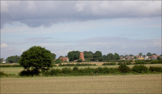
Figure 1: Lings Windmill near Dunscroft stands within well preserved surveyed enclosure, typified by straight sided hedged enclosures and regular planned layouts.
© Steve Fareham 2007 and licensed according to a creative commons license http://creativecommons.org/licenses/by-sa/2.0/
This zone is widely distributed across the borough of Doncaster, with examples found overlying areas of Coal Measure Sandstone, Magnesian Limestone and Bunter Sandstone geology. The defining characteristic of the zone is the regular plan form of its enclosure boundaries and roads, typically laid out in the drawing offices of 18th and 19th century land surveyors. The resulting landscape is characterised by perfectly straight hedgerows, although boundary removal across much of the zone, especially on the productive soils of the Magnesian Limestone ridge, has meant that many character units have been recorded in the project database as ‘Agglomerated Fields’. The most frequent Broad Types of character unit to be found in this zone are ‘Surveyed Enclosure’ (39%) and ‘Agglomerated Fields’ (47%), with the vast majority of the latter type having developed from degraded surveyed patterns.
Most roads in this zone are of standard and regular widths and are laid out to perfect straight courses. Such characteristics are typical of roads laid out by Parliamentary Enclosure surveyors nationwide (Hindle 1998). Such standardisation was a feature of enclosure countryside and can be seen as representative of a shift from vernacular to designed processes of landscape formation. In a similar vein, woodland in this zone has generally been recorded in as ‘Plantation’, rather than ‘Ancient’ or ‘Semi Natural’, having been planned deliberately as part of the surveyed layout, most likely in order to provide cover for game. These woodlands generally share the straight edges of the surrounding countryside, both in their external boundaries and in internal subdivisions.
Settlement within the zone is generally a mixture of dispersed 19th century farmsteads and 20th century residential ribbon developments. Farmsteads, where recorded by English Heritage in Listed Building descriptions, tend to be contemporary with, or later than, the date of the Parliamentary Enclosure of the surrounding land. However, there are earlier examples in the Hatfield / Hatfield Woodhouse, Fosterhouses and Moss character areas, where some earlier loose nucleations can be found. The 19th century farmsteads generally align with the surrounding enclosure fields, indicating their contemporary or later date, as does their plan form, which principally corresponds to the courtyard plan type. Characterisation of farmstead types in Yorkshire has revealed that farms based around regular planned courtyards “were most commonly developed on arable-based farms established as a result of enclosure from the later 18th century” (Lake and Edwards 2006, 44). The building materials of farmsteads in this zone generally follow the underlying geology, with limestone rubble preferred, when available, to the locally produced bricks that are used elsewhere. Tile is a common choice for roofing, across the zone.
Relationships with Adjacent Character Zones
The landscapes of this zone alternate to the west of the district with landscapes of the ‘Agglomerated Enclosure’ zone, situated across the Limestone and Sandstone geology. Distinctions between the two zones can be subtle and difficult to identify on the ground, with both types having been subject to subsequent 20th century agricultural intensification.
Scattered throughout this zone are a number of villages from the ‘Nucleated Rural Settlement’ zone. In the medieval period, these settlements were often surrounded by open field agricultural systems. Parts of these field systems were enclosed in a piecemeal fashion and are found within the ‘Strip Enclosure’ zone. In such locations, the ‘Surveyed Enclosure’ zone was often the final phase of enclosure of the former open fields.
In the 20th century the underlying limestone bedrock and coal seams of the zone were intensively exploited, and significant landscapes of the ‘Extractive’ and ‘Post Industrial’ zones exist in close proximity to this zone – sometimes as islands within it. These zones can be highly visible, particularly when spoil heaps, either active or re-landscaped, are present.
Inherited Character
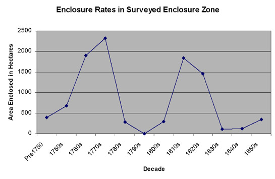
The character of 92% (by area) of this zone post dates the 1760s, with the vast majority having been subject to surveyed enclosure, typically by Parliamentary Act, since that date. Analysis of the rate of parliamentary enclosure shows two peaks - during the 1760s-1770s and again during the 1810s-1820s. Similar patterns have been noticed nationally (see fig 1 Turner 1986). Examining each of these bursts of enclosure in turn reveals an interesting pattern.
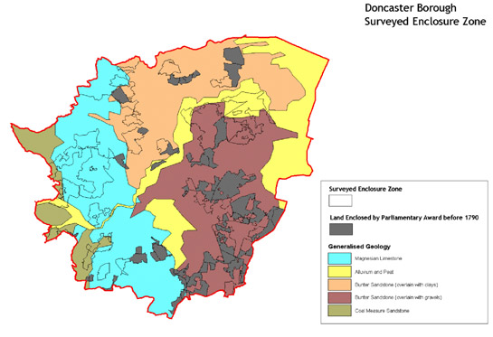
The earlier enclosures, dating to the period before 1790, are concentrated towards the east of the borough, away from the arable heartlands of the Magnesian Limestone ridge. During this period, the improvement of marginal land appears to have been the dominant motivation for enclosure, with 70% of the areas enclosed during this period showing an earlier character of ‘Commons and Greens’; ‘Wetland Common’; ‘Wet Wood’; ‘Ancient Woodland’ or ‘Moorland’.

Figure 2: The rate of enclosure, by decade, in the Surveyed Enclosure zone - from 1750-1860
By contrast, after 1790 there was a significant increase in the enclosure of land connected to open field agriculture; character units that had been part of open fields or were early piecemeal enclosure make up 57% of the land enclosed during this period. It is during this period that the remnants of ‘common’ arable production across the Magnesian Limestone were extinguished.

Figure 3: The distribution of land in the Surveyed Enclosure zone enclosed before and after 1790, in relation to underlying geology
Parliamentary enclosure of the remnants of common fields resulted in a highly complex pattern of historic legibility in many areas, which can be seen quite clearly on historic maps. In many of the character units with a ‘common’ arable past it is apparent that significant areas of former open field had already seen strips enclosed by private agreement, prior to any Parliamentary Award. Following enclosure awards, former open field areas can, therefore, often include mixes of straight (Parliamentary) and curving (private) boundary features. However, subsequent boundary removals across the borough have seriously denuded these patterns in most cases. Legible evidence of open field agriculture is, therefore, rare within this zone. The irregular external boundaries of former open fields are more likely to have been preserved than internal divisions, as they often form boundaries to roads, the edges of individual landholdings and parish boundaries. In many cases, former open fields can be identified by field names shown on historic Ordnance Survey maps that are always associated with a number of modern land parcels rather than individual ones (Oliver 1993, 56).
Legibility of previous landscape characteristics is less easy to discern in areas of former common land. The lack of earlier subdivisions in these areas allowed the award surveyors a freer hand to design the new landscape than in open field areas. Earlier informal tracks across common lands appear to have been formalised by these awards, typically being enclosed between hedgerows. As in former open field areas, the name of the former common, woodland or wetland is typically retained to identify the newly enclosed land and so is included on historic Ordnance Survey mapping.
It is likely that the enclosure and subsequent agricultural use of former common lands has significantly reduced the legibility of much earlier activity that may formerly have been visible. Unploughed common land would have been an ideal location for prehistoric and earlier historic monuments to have survived as upstanding earthworks. For example, documentary evidence (Hunter 1831, 61; Large 1952, 2) suggests that three burial mounds existed on Barnburgh Common until their deliberate levelling at the time of the Barnburgh-cum-Harlington Enclosure Award of 1819 (English 1985).
Even so, evidence for earlier landscapes have been sporadically observed and photographed, as variations in the colour of ripening crops, since the mid 1970s (see for example Riley 1980). This includes evidence for features dating back to the Iron Age / Romano British periods (Roberts et al 2007, Chapter 8). This aerial photographic evidence has recently been mapped (Roberts et al 2007) and comparison of these former landscapes with those recorded by this project shows that there is substantial discontinuity between the pattern of prehistoric/Roman field systems and the pattern of medieval land use that can be reconstructed in this zone. Few, if any, boundary features of the prehistoric/Roman landscape seem to have survived and been reflected in the medieval field pattern. Iron Age and Romano-British enclosed landscapes appear in areas characterised during the medieval period as both common grazing and common arable cultivation – suggesting that the division to ‘field’ or ‘common’ was not influenced by earlier patterns of land use.
The distribution of surviving traces of this earlier landscape are affected by a number of factors, including the permeability of the underlying geology, which affects the degree to which crop marks are likely to form (ibid, Chapter 8, p2 and Appendix 3). The more freely drained the soils, the more they are prone to drought, placing crops under stress and encouraging differential crop growth and, hence, the formation of crop marks. Within this zone, the crop marks indicating buried features correspond closely to the area underlain by Magnesian Limestone and to areas of glacial gravels overlying the Bunter Sandstones.
Later Characteristics
The loss of boundaries that has produced the relatively open character of much of this zone appears to have been most significant in the second half of the 20th century. During this period the increased mechanisation of agriculture further increased the benefit of large, straight-edged land enclosure, and in some areas this process has continued into the present; the economies of scale provided to farmers by larger land parcels continue to offer incentives to remove hedgerows. At farmstead sites, this agricultural intensification has been accompanied by continued investment in larger buildings, typically sheds built from prefabricated materials, less indicative of their function or local origins than earlier farm buildings.
Acting to counter these trends are incentives offered by the ‘stewardship’ schemes sponsored by central government since the early 1990s. These schemes offer financial incentives to farmers who enter into environmental management agreements, which can include steps to maintain or restore historic features such as boundaries and buildings, and (under the Environmental Stewardship system in place since 2005) reduce the impact of farming activities on known buried archaeological sites (Rural Development Service 2005, 68-70).
A contemporary development was the introduction of the Hedgerow Regulations of 1997 (HMSO), which require the notification of the Local Planning Authority before the removal of a hedgerow; the Regulations also confer powers on the same authority to serve a “Hedgerow Retention Notice” where hedgerows can be defined as important in historical, archaeological, wildlife or landscape terms.
Of other influences changing the character of land within this zone, since the mid 20th century, those connected with leisure are particularly significant. Newly created landscapes in this zone include: 5 golf courses, covering 225 hectares; 4 horticultural nurseries; 2 fishing ponds created at disused gravel extraction sites; and a racecourse. Commercial influences include the creation/expansion of a number of quarries for limestone and gravel.
Other late 20th/ early 21st century influences on this character zone relate largely to the influence of adjacent zones. Most notable is the effect of the A1 dual carriageway and the M18 motorway, west of Wadworth Interchange (itself part of the Post Industrial character zone), which promote developments on adjoining land. The roads’ dominant constructional materials are concrete, steel and massive earthen embankments, which generally sever previously coherent landscape units into new, smaller ones.
Character Areas within this Zone
Map links will open in a new window.
- Barnby Dunn Surveyed Fields (Map)
- Bawtry area Surveyed (Map)
- Braithwell to Wadworth Surveyed (Map)
- Brodsworth to Barnburgh Common Surveyed Countryside (Map)
- Cadeby Surveyed Enclosure (Map)
- Cantley and Aukley Commons (Map)
- Conisborough Parks Surveyed (Map)
- Denbay Surveyed (Map)
- Fenwick and Moss Surveyed Enclosures (Map)
- Enclosed Land between Hatfield and Hatfield Woodhouse (Map)
- Norton-Owston Surveyed Countryside (Map)
Bibliography
- English, B.
- 1985 Yorkshire Enclosure Awards. Hull: University of Hull.
- Hindle, P.
- 1998 Roads that ramble, and roads that run. British Archaeology [online], 31. Available from: www.britarch.ac.uk/ba/ba31/ba31feat.html
- Hunter, J.
- 1831 South Yorkshire: Volume 2. Sheffield: Pawson and Brailsford.
- HMSO
- 1997 The Hedgerows Regulation (Statutory Instrument 1997 No.1160)
- Lake, J. and Edwards, B.
- 2006 Historic Farmsteads. Preliminary Character Statement: Yorkshire and Humber Region. Cheltenham: University of Gloucester Countryside and Community Research Unit / English Heritage / Countryside Agency.
- Large, J.S.
- 1952 A History of Barnburgh. Mexborough: Russells Ltd.
- Oliver, R.
- 1993 Ordnance Survey Maps: a concise guide for historians. London: Charles Close Society for the study of Ordnance Survey Maps.
- Riley, D.N.
- 1980 Early Landscape from the Air: studies of crop marks in South Yorkshire and north Nottinghamshire. Sheffield: Dept of Prehistory and Archaeology.
- Roberts, I., Deegan, A., Berg, D. and Ford, L.
- 2007 Landscapes of the Magnesian Limestone [unpublished]. Morley: Archaeological Services WYAS.
- Rural Development Service
- 2005 Higher Level Stewardship
- Turner, M.
- 1986 Parliamentary Enclosures: Gains and Costs. ReFRESH [online], 3. Available from: www.scottishcommons.org/docs/english_enclosures.pdf
