Private Parkland Zone
Summary of Dominant Character
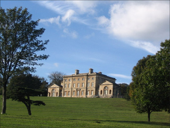
Figure 1: Cusworth Hall
© Dave Pickersgill and licensed for reuse under a creative commons license http://creativecommons.org/licenses/by-sa/2.0/
The defining historic characteristic of this zone is the use of land as ornamental parkland chiefly from the 18th to late 19th centuries. Many features created during this time continue to have a major impact on current landscape character. Character areas in this zone are frequently clearly separated from surrounding countryside by circuits of walls or plantation woodlands, providing screening and enclosure, although these may be broken or absent where agricultural use has been reintroduced within the park boundaries. Trees and woodlands are an important feature of most of these landscapes, with deciduous plantation and ancient woodlands being not only ornamental, but also providing cover for game. Open areas are often punctuated by scattered trees, with the surrounding ground cover typically either permanent grassland, maintained as pasture, or, in many cases, managed for arable cultivation. The focal point of many of these parks is a large elite residence and related ‘home farm’ complex, sometimes on the fringe of an older village; in some cases no hall survives.
Common design features in this zone include: ornate gateways and lodges; tree lined avenues and curving driveways; architectural follies, statuary, fountains and summerhouses; artificial lakes and ponds; formal gardens; and kitchen gardens. Such features were generally intended to emphasise the high status of the park’s owners.
Relationship to Adjacent Character Zones
The distribution of the character areas within this zone frequently relate to areas of farmland economically productive during the 18th and 19th centuries. A notable concentration of parkland can be found in relation to the economically productive agricultural landscapes of the Southern Magnesian Landscape (Countryside Commission 1996). A close relationship also exists between the landscapes of this zone and the ‘Surveyed Enclosure’ zone, with nearly all examples adjacent to areas of land enclosed by parliamentary award.
The character areas within this zone are also often closely related to the ‘Nucleated Rural Settlement’ zone - with many examples abutting or surrounding older villages; a relationship that will be explored further below.
Inherited Character
The practice of setting aside large tracts of land for the exclusive use of a small, restricted and powerful social group is much older than the period in which the parks of this zone were established. The medieval landscape of South Yorkshire included at least 26 specially enclosed or imparked areas, created specifically to enclose a population of deer for hunting (Jones 2000, 91). In Doncaster (although, notably, outside the areas included within this zone) three enclosed deer parks are known from the medieval period at Conisborough (Jones 2000, 94), Finningley (Hunter 1828, 79), and Hatfield (ibid, 155). Within this zone, a further probable deer park existed at Owston, thought to be on the site of the present Owston Park (Roberts 1995). This is the only known example of medieval parkland in this zone and some legibility of this former medieval park can still be seen in the current landscape; a circuitous boundary can be traced around the site, likely to represent the original park pale that defined the demesne lands of the manor. Medieval deer parks performed a much less aesthetic function than their post-medieval counterparts, but nevertheless required considerable maintenance, representing significant investment in land resources. Most were being broken up by the 16th and 17th centuries as these maintenance costs stretched their owners’ resources (Rackham 1986, 126), with many deer parks divided into enclosed land and woodland.
Following the European renaissance, the idea of parkland was reborn as a focus for the display of status and wealth through the aesthetic manipulation and presentation of land. Early examples, such as the park established for Godfrey Copley at Sprotborough in the late 17th century (Klemperer 2003, cited in Fenton-Thomas 2006, 13) took their influences from formal continental models (Copley had been influenced by a visit to Versailles) based on the geometric division of space through the use of features such as low parterre hedges; regular straight avenues of trees; and rectangular ‘canals’. During the 18th century this formal and geometric aesthetic was challenged by English landscape designers such as Lancelot ‘Capability’ Brown [1716-1783] and Humphry Repton [1752-1818] (Rackham 1986, 129). Both Brown and Repton championed a naturalistic, ‘picturesque’ approach to landscape, following artists such as Claude Lorraine. The majority of parks surviving in the Doncaster ‘Private Parklands’ zone were either originally designed in this style or were re-ordered to conform to it during the 18th and 19th centuries.
In a number of cases, the sites chosen for their new parks by landowners were already the sites of existing large houses and halls, some the sites of medieval manor houses. Medieval manor houses are known or probably existed at Brodsworth Park, Cusworth Park, and Wadworth Hall, with Tudor or earlier building fragments known at Hickleton Hall, Burghwallis Hall, High Melton Hall, Loversall Hall and Owston Hall (compiled from Roberts 1995). At Burghwallis the site of a moated manor house may survive as a small pond within the former park (see Keith 2002, 5.3.3).
Where these parks relate to existing elite residences there is usually a close relationship to a pre-existing medieval nucleated settlement. At Bilham and Owston there is strong evidence for deliberate clearance of earlier villages at the time of emparkment. Evidence also exists for the deliberate re-routing of important roads and the alteration of parts of villages at Burghwallis, Brodsworth, Hickleton, Cusworth, High Melton, and Loversall (see ‘Nucleated Rural Settlement’ zone and individual gazetteer entries). The built fabric of the remaining buildings of these villages shows clear evidence of investment by estates in their appearance, through the rebuilding of tied cottages and facilities. Other evidence of medieval settlement within these ‘Private Parkland’ areas includes the medieval churches of Loversall, High Melton and Brodsworth, which were deliberately included within later parks. This thorough reworking of existing rural forms has been associated by some authors (see Roberts 1995, 2-4; Newman 2001, 105) with the creation by the park sponsors and designers of an idealised countryside, physically and historically separated from the truth of its past.
The 18th and 19th century creation of many of these parks served to preserve a number of pre-existing boundary and earthwork features from earlier agricultural landscapes. The designers of parklands would generally set out to create, “an appearance of respectable antiquity from the start, incorporating whatever trees were already there” (Rackham 1986, 129). This approach is likely to have fossilised earlier steeply sloping ancient woodlands and boundary features along the edges of parks. A less deliberate class of fossilised features within these parks are ridge and furrow earthworks, preserved by their removal from arable cultivation at impartment, and earthworks from the tofts and crofts of deserted and shrunken settlements. Examples of ridge and furrow can be found at Loversall and Owston.
Parks that were not linked directly to earlier manorial estates are more likely to have been created by individuals belonging to the gentry rather than aristocratic classes. Examples in this zone include Rossington Hall and Park, and Wyndthorpe Hall and Park. At Rossington, a new park was created in 1773 on the former Rossington Common by Doncaster Town Clerk James Stolvin, shortly following its parliamentary enclosure in 1771 (Roberts 1995). At Wyndthorpe the small simple park still retains the triangular shape of earlier common land.
Later Characteristics
The economic pressure that these large tracts of land and their accompanying mansions put upon owners appears, in most of the examples in this zone, to have been too great to maintain their use as originally designed. Stolvin found the financial outlay necessary to create Rossington Park and the Shooters Hill mansion too great and was forced to sell his stake in the property after only a few decades (Roberts 1995).
Most properties in the zone seem to have experienced major changes of use in the period 1900-1950, with a number of houses transferring to institutional use during this period: Burghwallis Hall (convent school), Hickleton Hall (girls’ school and later care home), High Melton Hall (military training camp and later further education college) and Woodlands Hall (miners’ welfare institute). With the exception of Burghwallis Park (where conversion to agriculture removed most internal specimen trees), the accompanying ornamental grounds survive to some extent. At Woodlands part of the park survives around the hall, whilst another fragment was incorporated into the model village built for the Brodsworth Colliery Company by Percy Bond Houfton. This period also saw Owston Park converted into a golf course before its conversion to agriculture during World War II1.
Arable cultivation of parkland is noticeable at a number of the houses where residential occupation of the mansion appears to have persisted into the later 20th century, most noticeably at Cusworth and Brodsworth, two of the grandest houses of the district. At both sites, new enclosure boundaries were introduced within the park during the mid 20th century; by the late 1990s cultivation was integrated with the surrounding intensive arable regimes. At Cusworth, the agricultural intensification that followed the bisection of the park by the A1 Doncaster Bypass in the late 1960s has erased much of the earlier park boundary. At Brodsworth, much of the mature planting within the park survives within the newer arable landscape and the screening plantations are largely intact.
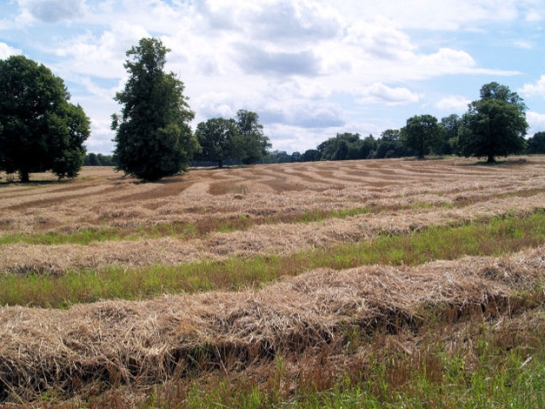
Figure 2: Part of Brodsworth Park converted to arable production in the 20th century but retaining specimen trees planted for ornamental purposes.
© 2007 Steve Fareham, licensed for reuse under a creative commons license http://creativecommons.org/licenses/by-sa/2.0/
More recently, the late 20th century trend to maintain elite landscapes as heritage sites has led to restoration programmes of both house and garden at Brodsworth and Cusworth, by English Heritage and Doncaster MBC respectively, following their purchase from ancestral owners.
Pressures for housing development may alter surviving smaller parkland landscapes, a process already apparent at Hesley Park where some small scale residential development was undertaken around the hall and farm c.2005.
Character Areas within this Zone
Map links will open in a new window.
- Bilham Park (Map)
- Bramwith Hall (Map)
- Brodsworth Park (Map)
- Burghwallis Park (Map)
- Campsall Park (Map)
- Cantley Park (Map)
- Cusworth Park (Map)
- Hesley Park (Map)
- Hickleton Park (Map)
- High Melton Park (Map)
- Loversall Park (Map)
- Owston Park (Map)
- Rossington Hall and Park (Map)
- Wadworth Hall (Map)
- Woodlands Park (fragment) (Map)
- Wyndthorpe Hall and Park (Map)
Bibliography
- Countryside Commission
- 1996 Southern Magnesian Limestone: Character Area 30 [online]. London: Countryside Commission. Available from: http://www.countryside.gov.uk/Images/JCA30_tcm2-21135.pdf [accessed 4 February, 2008]
- Fenton-Thomas, C.
- 2006 Sprotbrough Gardens: report on an archaeological excavation [unpublished]. York: On Site Archaeology. Report no. OSA01EX03
- Hunter, J.
- 1828 South Yorkshire: the History and Topography of the Deanery of Doncaster in the Diocese and County of York. London: Joseph Hunter / J.B. Nichols and Son.
- Jones, M.
- 2000 The Making of the South Yorkshire Landscape. Barnsley: Wharncliffe Books.
- Keith, K.
- 2002 Spindlewood, The Abbe’s Walk, Burghwallis, South Yorkshire: Desk-based appraisal [unpublished]. Morley: Archaeological Services WYAS for Fairclough Homes Ltd. ASWYAS report No. 977
- Klemperer, M.
- 2003 Style and Social Competition Between the Landed Classes Articulated Through the Large Scale Ornamental Landscapes of the Doncaster District of South Yorkshire 1680-1840. PhD Thesis, Dept of Archaeology, University of Sheffield
- Magilton, J.R.
- 1977 The Doncaster District: An archaeological survey. Doncaster: Doncaster MBC Museum and Arts Service.
- Newman, R; Cranstone, D; and Howard-Davis, C.
- 2001 The Historical Archaeology of Britain c.1540-1900. Stroud: Sutton Publishing Ltd.
- Rackham, O.
- 1986 The History of the Countryside. London: J.M.Dent.
- Roberts, J.G.
- 1995 Altered by the Hand of Taste: Halls, Parks and Landscapes in the Doncaster area of South Yorkshire, 1660-1850. BA(hons) dissertation, Department of Archaeology and Prehistory, University of Sheffield.
- Symonds, J. and Davies, G.
- 1995 An Archaeological Field Evaluation of Land at Owston Hall and Park [unpublished]. Sheffield: ARCUS report no 188b
1Owston Park was re-imparked as a golf course in the 1990s (Symonds and Davies 1995)