Doncaster Replanned Centre Zone
Summary of Dominant Character
The dominant theme of this zone was urban renewal of the town of Doncaster, post-World War II, with areas generally cleared wholesale of earlier buildings and features, and street patterns reconfigured. This character zone overlaps much of the area of the medieval town of Doncaster, as defined by Slater’s analysis of the plan form of Doncaster (Slater 1989 and see also in ‘Doncaster Complex Historic Town Core’ plan form analysis - above). The redevelopment characteristic of this zone has generally re-written the earlier urban pattern of this area of the town.
The majority of this character zone has been recorded as post-dating 1970, although this date reflects the date of mapping available to the project (after the late 1940s OS edition) and as a result many developments may actually have originated in the 1950s and 1960s.
The largest Broad Type of the character units within the zone (41%) is commercial, including large pedestrian covered retail complexes such as the Frenchgate, Waterdale and Colonnades centres and the superstores and retail warehouses around North Bridge Road and St Sepulchre Gate. A further major character type within the zone is accounted for by ‘institutional’ properties. These make up around a quarter of the area of the zone, chiefly the 7 hectare former main campus of Doncaster College at Waterdale.
The components of this zone are linked by a gyratory system of roads, designed as urban dual carriageways, which pedestrians were generally discouraged to cross at surface level. To facilitate crossing, a large number of pedestrian bridges and subways were built, especially at roundabouts. Character units within the ‘Communications’ Broad Type, which includes categories such as ring road, car parks and bus stations / interchanges, account for 27% of the land within the zone.
Inherited Character
Much of the developments within this zone are likely to have been undertaken following bulk purchases (often compulsory) of land, enabling their development to ignore historically established patterns of property ownership. As a result of this level of rebuilding, only a few characteristics of earlier historic development are legible within this area.
Of the area of this zone included within Slater’s plan form analysis of the historic town of Doncaster, the majority of the developments here have no legibility of earlier character development.

Figure 1: Showing the extent to which the ‘Replanned Centre Zone’ overlaps with the medieval core of the town.
Background mapping taken from the 1854 6 inch OS survey © and database right Crown Copyright and Landmark Information Group Ltd (All rights reserved 2008) Licence numbers 000394 and TP0024
As the figure above demonstrates, much of this new development has overwritten patterns of historic development dating back to at least the medieval period. This all pervasive disruption resulted from the construction of the Church Way, Trafford Way, North Bridge Road and Cleveland Street dual carriageways - all of which took largely new courses across older urban plan patterns. This upgraded road system began to take shape (between 1906 and 1930) as a result of the construction of the North Bridge Road section of the A1 - Great North Road, through the middle of the Marsh Gate suburb (identified by Slater as plan unit VI, a potentially medieval suburb (1989, 54-55)). Construction of the new road diverted the Great North Road from its historic course along Marsh Gate, through an area of historic burgage plot boundaries and the site of the medieval Franciscan Friary.
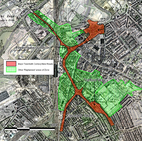
Figure 2: Major 20th century roads have overwritten earlier historic patterns within the Replanned Urban Centre character zone.
HEC data overlain on 1920s OS 6 inch data © and database right Crown Copyright and Landmark Information Group Ltd (All rights reserved 2008) Licence numbers 000394 and TP0024
The remainder of this road system was first laid out in the 1960s-1970s. Working from south to north, the system funnels traffic from the south and west along Cleveland Street and Trafford Way around the edges of a large contemporary Doncaster MBC housing estate towards the Trafford Way roundabout. Trafford Way carries traffic diverted from the historic Great North Road, as well as that entering the town from the M18 along White Rose Way, and Cleveland Street diverts traffic from the historic line of St Sepulchre Gate. The southern parts of this road system are constructed across areas formerly occupied by late 19th century terraced housing. To the east of the Trafford Way roundabout, a large area of late 19th century grid iron housing (one of the first to develop in Doncaster) was cleared in the same period. This area is now occupied by the Colonnades and Waterdale shopping precincts. These areas follow the alignment of, but preserve little else of, the earlier residential suburb.
In the west and north of the town, traffic moves along Trafford Way and cuts through the historic suburb of St Sepulchre Gate (Slater’s plan unit VII), before turning to the north east through an area formerly characterised by burgage plots (Slater’s Frenchgate unit II). Much of the western side of French Gate was demolished the late 1960s in order to make way for the Arndale Centre (renamed as the Frenchgate Centre in the later 1980s). French Gate was originally made up of thin narrow plots, part of a plan form unit with burgage plots of common lengths and widths on both sides of French Gate, which are now almost entirely lost above ground. The French Gate plots were originally constrained by a medieval ditch, the Bar Dike, which - with the river Cheswold - completely enclosed the core of the medieval market town. The line of this ditch continues to be represented for much of its length, outside the ‘Replanned’ character zone, by the course of Printing Office Street and Silver Street / Market Road. However, 1970s additions to the Frenchgate Centre have completely overbuilt its course within this zone.
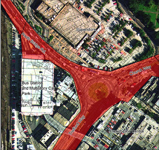
Figure 3: The current plot boundaries around Frenchgate Junction are defined primarily by the 20th century roads that meet here.
This image is based on a 1999 aerial photograph (©Cities Revealed aerial photography © the GeoInformation Group, 1999) showing the former bus station before its redevelopment as ‘Frenchgate Interchange’.
Moving further north, the road system reaches Frenchgate Junction, a roundabout linking Trafford Way with North Bridge Road and Church Way. This is centred on the historic route of Frenchgate but overlies the frontages of burgage plots to both sides of the older road. The 20th century roads define two new plots to either side of North Bridge Road. The western most of these plots was the site of the main bus station and its associated multi-storey car park (until the 21st century construction of Frenchgate Interchange), whilst the eastern most was developed in the early 1980s as a large supermarket.
Church Way, developed in the early 1970s (Buckland et al 1989, 68), cuts across Slater’s unit I, an area successively defended by enclosure ditches based on those of the later Roman fort that formed an important determinant of the later plan of the medieval town. Demolition of existing buildings and construction of the new road resulted in the removal of plots around the medieval churchyard and the agglomeration of some of the area of the later Roman fort into the rear of the plots fronting on to Baxter Gate / Market Place. The modern road now forms the southern boundary of St George’s Conservation Area (Judge 2005).
At the north-eastern corner of this character zone, the St George’s Gyratory roundabout broadly corresponds to the area of Slater’s Fishergate plan unit IV. The irregular streets and plots shown on historic plans in this area were probably populated during the medieval period by timber framed buildings on stone foundations. Excavation and documentary sources give strong indications of industrial occupation, which probably related to medieval waterfront activity that was itself preceded by a Saxon quay discovered through excavation (Lilley 1994, 36). Modern transport alterations have completely altered the form of this area, first through a re-direction of the course of the Don to the north (cutting off the section known as Gashouse Bight, between 1930 and 1948) and, in the early 1970s, by the demolition of the entire area of Fishergate / Friendless Street and the construction of a multi-storey car park, roundabout and carriageways associated with the development of the Church Way inner relief road scheme. The car park and roundabout were replaced by the present major interchange gyratory system in the early twenty first century as part of the implementation of the North Bridge Relief Road Scheme (Jim McNeil pers. com).
Later Characteristics
The present project was undertaken during 2006 using map data surveyed up to 1999-2003, making more recent changes difficult to capture. Major known recent changes include the redevelopment and extention of the Frenchgate Centre / Frenchgate Interchange complex; the construction of the North Bridge Relief Road to the north west of St George’s Gyratory; and the construction of Doncaster college’s Hub Campus at Gas House Bight to the north of the zone. This final development will enable the redevelopment of the old College campus; Doncaster MBC currently envisage this work to involve the development of a ‘cultural and civic quarter’ including council offices, retail provision, a library building and performance space.
Character Areas within this Zone
Map links will open in a new window.
Bibliography
- Buckland, P.C., Magilton, J.R. and Hayfield, C.
- 1989 The Archaeology of Doncaster 2. The Medieval and Later Town. Oxford: BAR British Series 202.
- Judge, K.
- 2005 St George’s Conservation Area: Conservation Plan.
- SCC (Sheffield City Council)
- 1945 Sheffield Replanned: A Report, with plates, diagrams and illustrations, setting out the problems in re-planning the city and the proposals of the Sheffield Town Planning Committee. Sheffield: Sheffield City Council.
- Slater, T.R.
- 1989 Doncaster’s Town Plan: An Analysis. In: P.C. Buckland, J.R. Magilton and C. Hayfield, The Archaeology of Doncaster 2. The Medieval and Later Town. Oxford: BAR British Series 202, 43-61.
- Smith, A.H.
- 1969 The Place-names of the West Riding of Yorkshire: Part One. London: Cambridge University Press.