Early to Mid 20th Century Private Suburbs
Summary of Dominant Character
This zone is characterised chiefly by small areas of housing developed speculatively between 1914 and 1945, in estates or as areas of ribbon development on the edges of existing settlements. Stylistically, developments in South Yorkshire during this period have much in common with areas developed in the ‘Municipal Suburbs’ and ‘Planned Industrial Settlements’ zones. Differences are likely to include larger housing units, with more variety of housing types along individual streets, and an increased number of status differentiating features such as hung tiles, bay windows, stained glass and street trees. Similarities with the municipal and industrial housing of the same period include geometric street patterns and spaciously arranged medium density housing patterns strongly influenced by the garden city designs of Ebenezer Howard. Howard was working in the late 19th and early 20th century, designing satellite settlements of low density houses with associated shops and recreational facilities (Edwards 1981, 83). These designs were adapted by Raymond Unwin and used as the basis for many municipal and private housing developments across the country (Unwin 1994 [1909], 236). As across South Yorkshire, generally, there is significantly less privately built housing of this period compared with municipal housing developments of the same date.
Blocks of housing within this zone tend to be relatively small and were often built to an overall plan, although the houses tended to be built in phases of piecemeal development. There is often a mix of detached and semi-detached housing within these estates; some houses were built in very different styles, where individual housing plots were filled independently.
The character areas making up this zone are located on the edge of existing settlements and are generally set away from industrial landscapes, continuing the trends of middle class suburban development established within the ‘19th to Early 20th Century Villa Suburbs’ character zone. Most of the areas within this zone are built along or near to main roads. Such ‘ribbon development’, where all or most of the houses are strung out along a main road, with each property featuring a driveway, was particularly suited to the requirements of the private house buyer of the early to mid twentieth century, who was increasingly likely to have access to a private car - used for commuting to a more distant place of work. At the time when these houses were built there were significantly fewer cars on the road than now, making these road side locations more desirable than they are currently. To the east of this character zone, and originally developed in a rural context, are the Hatfield Woodhouse and Dunsville character areas, the core of which originated as ‘ribbon’ developments and private speculative building projects.
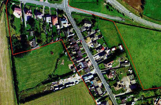
Figure 1: Early to mid 20th century ribbon development between Hatfield Woodhouse and Hatfield. Each property has both vehicular access to a main road, off-road parking, gardens to front and rear and is connected directly to open countryside.
Cities Revealed aerial photography © the GeoInformation Group, 2002
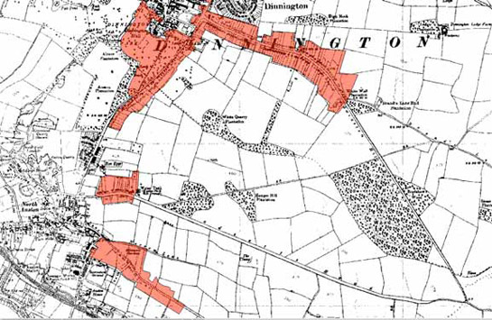
Figure 2: The ‘Anston and Dinnington Ribbon Developments’ character area (red shading), as depicted by the OS in 1938.
Base mapping © and database right Crown Copyright and Landmark Information Group Ltd (All rights reserved 2008) Licence numbers 000394 and TP0024
The large-scale and rapid growth of ‘ribbon development’ in the early twentieth century was a source of much controversy amongst town planners, who characterised its appearance as “bungaloid growth”, a phrase coined by 1920s polemicist Dean William Inge (The Times, 27th September 1927). This pejorative term was used to criticise developments that were generally inefficient in terms of their use of land, making it difficult to access the enclosed rural land behind the road. The calls of protest against ribbon development led to the passing of the ‘Restriction of Ribbon Development Act’ (25 & 26 Geo V, HMSO) in 1935, which gave local authorities the power to restrict development close to main roads, effectively curtailing further ribbon development on the scale that occurred during the main development period of this zone.
Relationships to Adjacent Character Zones
Areas within this zone tend not to be the first phase of settlement in an area but are built in relation to earlier settlements. These areas are also generally not the last phase of suburbanisation. This leads to early 20th century suburbanisation becoming sandwiched between bands of earlier and later suburbanisation.
Where early 20th century private suburbanisation has occurred on only a small scale, such areas have been considered as infill in various other character zones.
Inherited Character
The majority of this character zone consisted of enclosed land prior to its development for housing. Legible earlier characteristics therefore generally relate to inherited boundary patterns, where existing enclosures formed the units of later development. The remaining areas have been variously recorded by the characterisation project as residential, ornamental and wooded landscapes.
Where earlier residential development is recorded, the present housing generally represents intensification of earlier areas of historic or villa settlement. At Cantley, where the medieval church of St Wilfred’s [parts of which are thought to be Norman (Ryder 1982)] stood away from the nucleated settlement of Cantley in the 19th century, an earlier settlement has been absorbed by later development. This church, now surrounded by 20th century suburban housing, was surrounded by land enclosed from open fields by parliamentary award in the 19th century. Whilst there is no evidence to indicate a deserted nucleated village around this church, which Magilton suggests may have served a dispersed community (1977, 24), this possibility cannot be discounted; any earthworks and other evidence of former property boundaries are likely to have been destroyed at the time of enclosure.
Features of former elite residences and their parklands are better preserved. The ‘Sprotbrough Mid 20th Century Suburbanisation’ character area retains legibility of the former Sprotbrough Park, which was established during the late 17th century and reworked during the 18th and 19th centuries. Mid 20th century suburbanisation took place in this area following the breaking up of the park for sale in 1925 (Mellor 2006, 15).
Other legibility within this zone tends to be limited to earlier road patterns, which get incorporated into most developments, and to field boundary patterns at the edges of estates.
Later Characteristics
There has generally been little significant alteration to the character of this zone in the later half of the 20th century and the early 21st century. Within some estates buildings have been replaced, but the generally mixed nature of these suburbs often allows for this with little impact on historic character. Where houses have been built in a more uniform style, however, these additions tend to be more obvious. On an individual property scale, most changes in character are likely to have been limited to the replacement of doors and windows in UPVC, the construction of extensions and conservatories and the replacement of front gardens with hard standing areas for car parking.
Character Areas within this Zone
Map links will open in a new window.
- Auckley Mid 20th Century Suburban (Map)
- Austerfield Mid 20th Century Expansion (Map)
- Barnburgh Harlington Mid 20th Century expansion (Map)
- Bawtry Mid-Twentieth Century Suburbanisation (Map)
- Brampton earlier expansion (Map)
- Campsall Mid 20th century expansion (Map)
- Mid Twentieth Century Cantley and Bessacarr Suburbs (Map)
- Finningley Mid 20th Century Expansion (Map)
- Hatfield Woodhouse and Dunsville mid 20th century Ribbon Development (Map)
- RAF Lindholme Quarters (Map)
- Norton early to mid 20th Century Expansion (Map)
- Scawsby / Scawthorpe pre 1960 suburban (Map)
- Sprotborough mid 20th century suburbanisation (Map)
- Thorne Ribbon Development (Map)
- Warmsworth suburbanisation (Map)
Bibliography
- Edwards, A.M.
- 1981 The Designs of Suburbia. London: Pembridge Press.
- Howard, E.
- 1902 Garden Cities of Tomorrow. London.
- Mellor, I.
- 2006 Park Drive, Sprotbrough, South Yorkshire: Archaeological Desk Based Assessment [unpublished document]. Prepared for O’Neill Associates by Field Archaeology Specialists, York. Available for consultation at SYAS.
- Short, J.R.
- 1982 Housing in Britain: The Post War Experience. London and New York: Methuen.
- The Times
- 1927 The Rival Satirists. Editorial in The Times 27th September, 1927.
- Unwin, R.
- 1994 Town Planning in Practice: An Introduction to the Art of Designing Cities and Suburbs [originally published 1909]. Princeton: Princeton Architectural Press.
- Waithe, M.
- 2006 William Morris's Utopia of Strangers: Victorian Medievalism and the Ideal of Hospitality. Woodbridge: D.S.Brewer.
- Whitehand, J.W.R and Carr, C.M.H
- 2003 ‘Twentieth Century Suburbs’ in Urban Morphology 7, 1.