Industrial Settlements
Summary of Dominant Character
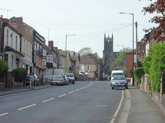
Figure 1: Rawmarsh Hill. The irregular terraced buildings here date to the second half of the 19th century as the earlier village (which lies to the far side of the medieval church) expanded to the south, largely in response to the growth of the Park Gate Iron and Steel Co.
Photo © SYAS
This zone is characterised by the development of settlements constructed primarily for the housing of industrial workers, outside the boundaries of historic medieval settlements. This housing often takes the form of conjoined row housing, often (when dating to the late 19th or early 20th century) similar in form to housing in the ‘Grid Iron Terraced Housing’ zone; older examples tend to be of more vernacular character. In contrast to the ‘grid iron’ settlement areas, housing neighbourhoods in this zone are generally fairly irregular in overall plan form. Key trends in the positioning of these industrial settlements include: close proximity to railways and canals; ribbon developments along existing roads; and use of sites that exploited land made available for construction by the parliamentary enclosure of former common land. There are also examples of irregular industrial expansion on the edge of historic cores.
In the Rotherham district, coal mining was a frequent influence on the development of this type of housing, for example at Kiveton Park, Greasebrough, Laughton Common, Fence, Silverwood, Treeton and Swallow Nest. However, other industries characteristic of the region, such as iron, steel and brass working, glass making, ceramic production, brick making and the railway trades also provided the impetus for construction, particularly around Rawmarsh and Swinton. Developments here provide a case study to show the typical development pattern for character areas within this zone.
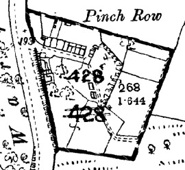
Figure 2: Pinch Row, Rawmarsh: The 1891 OS map (top) shows early-mid 19th century row housing; its site is shown on the aerial photograph in 1999 (above).
Historic mapping © and database right Crown Copyright and Landmark Information Group Ltd (All rights reserved 2008) Licence numbers 000394 and TP0024; Cities Revealed aerial photography © the Geoinformation Group, 1999.
The first stage in development typically saw the establishment of small clusters of cottages, often set out in the countryside in order to place the workforce close to isolated resources. Often these resources were exploited on areas of common land; both the former Rawmarsh and Swinton Commons had a long history of use, both before and after enclosure in 1776, 1781 and 1820 (dates from English 1985), for extraction of clay, stone, coal and timber. At least three families of colliers are recorded living and working on Rawmarsh Common during the first half of the 18th century, on parish registers and a Fairbank map of 1740 (Dodsworth 1996, 188-191). The Fairbank map clearly shows these families’ ‘crofts’ (enclosures including a house and a small piece of land) well within the boundaries of the common, close by coal pits - a good indication that they originated as ‘squatter settlements’, a type of settlement known to be occurring on common lands across Yorkshire from the 16th century onwards (Hey 1986, 170).
The erection of row housing was only necessary with the establishment of larger industrial concerns, such as the collieries that emerged during the 19th century. On the former Rawmarsh Common (but outside the present zone), row housing was present at Pinch Row, associated with a sandstone quarry, and at Meadow Pottery to the south of the common. These cottages, still shown on late 19th century mapping, were probably only one room deep (about 5m by 4m) and had been demolished by the 1960s.
By the late 19th century some industrial manufacturers were employing much larger numbers of workers than could be accommodated within the increasingly crowded historic settlement areas or within single rows of 5-10 houses.
The development of the ‘Ryecroft and Sandhill, Rawmarsh’ character area shows how, by this time, rows were built on a larger scale and were increasingly associated with the varied institutional and recreational facilities characteristic of these independent communities. Industrial settlements often feature allotment gardens and large areas of these can be seen on historic OS maps of these settlements. Other facilities included football and cricket pitches, recreation grounds and parks. In the mining villages these facilities were generally provided by the Miners Welfare Fund, the product of a levy paid by colliery companies of 1d on every ton of coal produced following the Mining Industry Act of 1920 (Griffin 1971, 170). These developments are often part of a phase of later improvements to the original industrial settlement.
‘Ryecroft and Sandhill, Rawmarsh’ character area in 1851. The future industrial suburb area (shaded red) is dominated by open agricultural land and parkland, with only very small hamlets at Lane Head and The Dale. The surrounding landscape includes Meadow Pottery, quarries and coal pits.
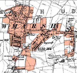
By 1905 suburbanisation is well underway with terraced housing clusters at Rose Hill, Ryecroft and Sandhill. Rose Hill Park has been adopted as a municipal park.
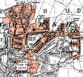
By 1938 the industrial suburb has further expanded, with remaining spaces either used for further housing, institutional buildings or allotment gardens.
Figure 3: The development of the ‘Rycroft and Sandhill, Rawmarsh’ character area showing some typical characteristics of the ‘Industrial Settlement' zone.
Historic OS mapping © and database right Crown Copyright and Landmark Information Group Ltd (All rights reserved 2008) Licence numbers 000394 and TP0024
Relationship with Adjacent Zones
The most obvious relationship between this zone and others is with the ‘Industrial’ and ‘Post Industrial’ zones, where the commercial concerns that influenced the development of these settlements are, or were, located.
Many of the character areas within this zone evolved as ribbon developments along the main roads leading into character areas belonging to the ‘Nucleated Rural Settlements’ zone.
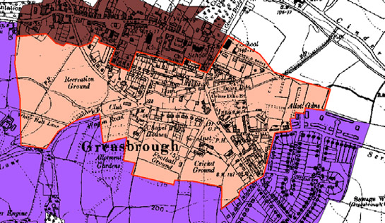
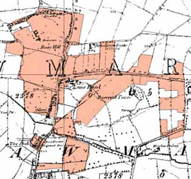
Figure 4: ‘Greaseborough Industrial Settlement’ (pink) grew up to the south of the historic settlement core (brown), around early squatter settlement on a former green. It is noticeably more irregular and varied in plan form than either the historic core or the municipal estates to the south (purple).
© and database right Crown Copyright and Landmark Information Group Ltd (All rights reserved 2008) Licence numbers 000394 and TP0024
Inherited Character
Characteristics of older landscapes have survived within this zone due to the piecemeal nature the later 19th and early 20th century developments. Many of the early phases of these developments took place along existing roads – as a result, the courses of these roads became fossilised in the developments and persist today. Elsewhere, existing rural enclosures often provided convenient development plots, especially the narrow units typical of post-medieval strip enclosures. Strips fossilised by the 19th century development of workers terraces survive across this zone, for example at Queen Street, Swinton, and throughout the Parkgate, Rawmarsh character area.
In 1851 the site of the later ‘Bradgate’ Industrial Settlement' was a small hamlet, typical of others in South Yorkshire thought to have originated as squatter settlements around common land. Industrial activity was already present locally in the form of coal pits and quarries.
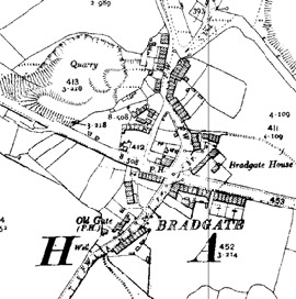
By the 1890s, the settlement had been enlarged by further row housing along the edges of existing roads and also along a newly built east - west road.
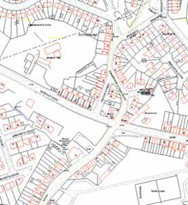
The modern settlement of Bradgate has legibility both of the earlier common and 19th century row housing, despite having been enveloped by 20th century housing.
Figure 5: Development of Bradgate.
Historic OS mapping © and database right Crown Copyright and Landmark Information Group Ltd (All rights reserved 2008) Licence numbers 000394 and TP0024; Modern maps © Crown copyright. All rights reserved. Sheffield City Council 100018816. 2007
Later Characteristics
The 1970s and 80s saw the closure of many of the industries that these settlements were established around, leading to significant hardship in the borough. After a period of neglect, the 1990s and early 21st century have seen a concerted effort to improve and regenerate former industrial settlements. This has involved demolition of cramped housing, sometimes leading to replacement homes being built, but also to land being left as urban green space. This pattern can be seen at Parkgate, for example, where the early phase of the industrial settlement has largely been demolished and the terraced housing replaced with hundreds of new homes.
Figure 6: The ‘Parkgate Rawmarsh’ character area, showing the date of individual character units. The terraced development clustered around the main road dates from 1855-1919 (shaded yellow); inter-war (1919-1945) terraces and allotment gardens are shaded grey; late 20th century (post 1975) housing, mostly municipal developments on the sites of cleared mid 19th century terraces, are shaded pink.
Cities Revealed aerial photography © the GeoInformation Group, 1999
As in the ‘Grid Iron Terraced’ zone, this zone has been vulnerable to the social changes of the late 20th century. The now widespread phenomenon of multiple car ownership has had a significant effect of the streetscape, with off-road opportunities for parking almost completely absent and on road opportunities limited by the inherent short street frontage of each property.
Within properties the most notable change has probably been the introduction of bathrooms and toilets within the main living accommodation, rather than contained within the back yard. Changes in property maintenance that has impacted on the general character of the area includes: the widespread replacement of wooden doors and windows with double glazed uPVC units; the replacement of welsh slate roofing with concrete and other composite materials; and the introduction of TV and satellite aerials.
Changes in attitudes and practices concerning religion and schooling are also manifesting themselves in the changing characteristics of former institutional buildings in this zone, with the buildings generally provided for these purposes now often put to re-use as community centres, clubs or youth centres.
Character Areas within this Zone
Map links will open in a new window.
- Fence Colliery Housing (Map)
- Garrowtree, Bradgate, and Kimberworth Industrial Settlement (Map)
- Greasebrough Industrial Settlement (Map)
- Holmes Insdustrial Settlement (Map)
- Kilnhurst Village (Map)
- Kiveton Park and Wales Colliery Housing (Map)
- Lane Head, Ryecroft and Sandhill, Rawmarsh (Map)
- Laughton Common Industrial Settlement (Map)
- Melton Green (Map)
- Park Gate, Rawmarsh (Map)
- Piccadilly (Map)
- Ryton Road, Anston (Map)
- Silverwood (Map)
- Swallow Nest, Aughton cum Aston Industrial Settlement (Map)
- Swinton Bridge Industrial Settlement (Map)
- Thrope Hesley Industrial Settlement (Map)
- Treeton Colliery Housing (Map)
- Whinney Hill, Thrybergh (Map)
- Wickersley Industrial Expansion (Map)
Bibliography
- Dodsworth, T.
- 1996 Rawmarsh Common: A Study in Landscape History. In: M. Jones (ed.), Aspects of Rotherham 2. Barnsley: Wharncliffe.
- English, B.
- 1985 Yorkshire Enclosure Awards. Hull: University of Hull.
- Hey, D.
- 1986 A Regional History of England: Yorkshire From AD 1000. London: Longman.