Early to Mid 20th Century Private Suburbs
Summary of Dominant Character
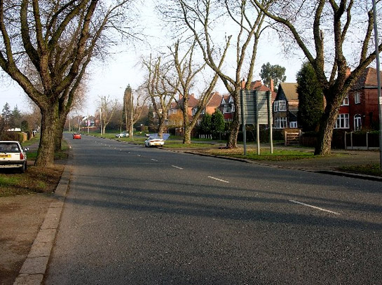
Figure 1: A street scene within the ‘Herringthorpe and Moorgate Early 20th Century Suburbs’ character area.
© 2006 Andrew Laughton used under a ‘Creative Commons’ licence (http://creativecommons.org/licenses/by-sa/2.0/)
This zone is characterised chiefly by areas of housing developed speculatively between 1914 and 1945 in small estates or as areas of ribbon development on the edges of existing settlements. Stylistically, developments in South Yorkshire during this period have much in common with areas developed in the ‘Municipal Suburbs’ and ‘Planned Industrial Settlements’ zones. Differences are likely to include larger housing units with more variety of housing types along individual streets, and an increased number of status differentiating features such as hung tiles, bay windows, stained glass and street trees. Similarities with the municipal and industrial housing of the same period include geometric street patterns and spaciously arranged medium density housing patterns strongly influenced by the garden city designs of Ebenezer Howard. Howard was working in the late 19th and early 20th century, designing satellite settlements of low density houses with associated shops and recreational facilities (Edwards 1981, 83). These designs were adapted by Raymond Unwin and used as the basis for many municipal and private housing developments across the country (Unwin 1994 [1909], 236).
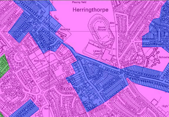
Figure 2: Housing patterns in this zone (blue) are similar in plan form to those in the contemporary municipal housing areas that often surround them (pink), but closer examination shows a lower density of development with greater frequency of detached housing and a concentration of development around main arterial roads.
© Crown copyright. All rights reserved. Sheffield City Council 100018816. 2007
As across South Yorkshire, there is significantly less privately built housing of this period than municipal housing developments of the same date. Blocks of housing within this zone tend to be relatively small and, although they were often built to an overall estate plan, the houses tended to be built in phases of piecemeal development. There is often a mix of detached and semi-detached housing within these estates; some houses were built in very different styles, where individual housing plots were filled independently.
The character areas making up this zone are located on the edge of existing settlements and are generally set away from industrial landscapes - continuing the trends of middle class suburban development established within the ‘19th to Early 20th Century Villa Suburbs’ character zone. Most of the areas within this zone are built along or near to main roads. Such ‘ribbon development’, where all or most of the houses are strung out along a main road with each property featuring a driveway, was particularly suited to the requirements of the private house buyer of the early to mid twentieth century, who was increasingly likely to have access to a private car used for commuting to a more distant place of work. At the time when these houses were built there were significantly fewer cars on the road making these road side locations more desirable than they are currently. Ribbon development is a particular characteristic of areas in this zone that were developed away from the main Rotherham conurbation, allowing each property to have both vehicle access from a main road at the front and direct visual access to countryside to the rear.
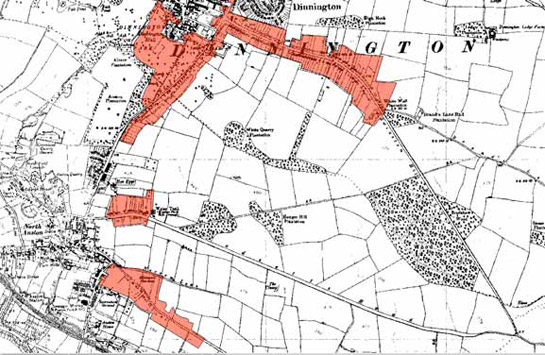
Figure 3: The ‘Anston and Dinnington Ribbon Developments’ character area (red), as depicted by the OS map of 1938.
Base mapping © and database right Crown Copyright and Landmark Information Group Ltd (All rights reserved 2008) Licence numbers 000394 and TP0024
The large scale and rapid growth of ribbon development in the early twentieth century was a source of much controversy amongst town planners, who characterised its appearance as “bungaloid growth” - a phrase coined by 1920s polemicist Dean William Inge (The Times, 27th September 1927). This pejorative term was used to criticise developments that were generally inefficient in terms of their use of land, making it difficult to access the rural land enclosed behind the road. The calls of protest against ribbon development led to the passing of the ‘Restriction of Ribbon Development Act’ (25 & 26 Geo V, HMSO) in 1935, which gave local authorities the power to restrict development close to main roads, effectively curtailing further ribbon development on the same scale as that which had occurred during the main period of construction in this zone.
Relationships to Adjacent Character Zones
Where early 20th century private suburbanisation has occurred on only a small scale, areas have been included as infill within various other character zones.
Character areas within this zone tend to be built in relation to earlier settlements. These areas are also generally not the last phase of suburbanisation, which leads to early 20th century suburbanisation becoming sandwiched between bands of earlier and later suburbanisation.
Inherited Character
87% of the area of this character zone consisted of Enclosed Land prior to its development for housing. The remaining area has been variously recorded by the characterisation project as residential, ornamental and wooded. Where earlier residential development is recorded, the present housing generally represents intensification within historic or villa settlement. Legible earlier characteristics within this zone generally relate to inherited boundary patterns, for example preserved back lane and field boundaries.
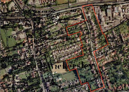
Figure 4: Part of the ‘Wickersley and Bramley Early 20th Century Suburbs’ character area (outlined in red), showing housing developed along both sides of a probable medieval back lane, with the housing to the west of the lane reusing, but subdividing older burgage boundaries.
Aerial photography © the GeoInformation Group, 1999; 1851 OS six inch to the mile mapping ? and database right Crown Copyright and Landmark Information Group Ltd (All rights reserved 2008) Licence numbers 000394 and TP0024
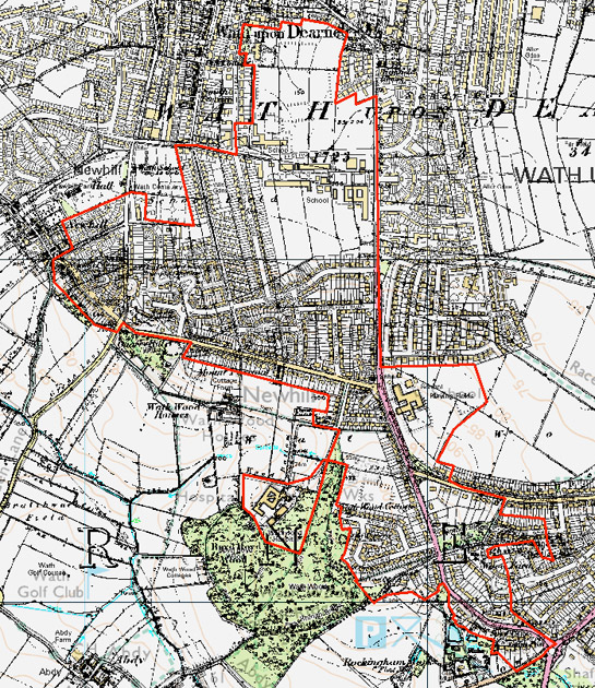
Figure 5: Large estates within this zone (such as these within the ‘Wath Mid Twentieth Century Suburbs’ character area) are less likely to preserve earlier boundaries than smaller scale developments.
Historic mapping © and database right Crown Copyright and Landmark Information Group Ltd (All rights reserved 2008) Licence numbers 000394 and TP0024: Modern mapping © Crown copyright. All rights reserved. Sheffield City Council 100018816. 2007
Later Characteristics
There has generally been little significant alteration to the character of this zone in the later half of the 20th century and the early 21st century. Within some estates buildings have been replaced, but the generally mixed nature of these suburbs often allows for this without loss of historic character. Where houses have been built in a more uniform style, however, these additions tend to be more obvious. On an individual property scale, most changes in character are likely to have been limited to the replacement of doors and windows in uPVC, the construction of extensions and conservatories, and the replacement of front gardens with hard standing for car parking.
Character Areas within this zone
Map links will open in a new window.
- Anston and Dinnington Ribbon Developments (Map)
- Aughton and Aston Early 20th Century Suburbs (Map)
- Catcliffe and Brinsworth Suburban (Map)
- Doncaster Road, Dalton (Map)
- Harthill Early 20th Century Suburbs (Map)
- Herringthorpe and Moorgate Early 20th Century Suburbs (Map)
- Hoober Suburban (Map)
- Hood Hill and Harley (Map)
- Kimberworth Early 20th Century Suburbs (Map)
- Kiveton Park Ribbon Development (Map)
- Letwell Ribbon Development (Map)
- Maltby Early 20th Century Suburbs (Map)
- Ravenfield Common Ribbon Development (Map)
- Rawmarsh Early 20th Century Suburbs (Map)
- Swinton Early 20th Century Suburbs (Map)
- Thorpe Common Suburbs (Map)
- Thorpe Salvin Early 20th Century Suburb (Map)
- Treeton Early 20th Century Suburb (Map)
- Wales Early 20th Century Suburbs (Map)
- Wath Mid Twentieth Century Suburbs (Map)
- Wickersley and Bramley Early 20th Century Suburbs (Map)
- Woodsetts Early 20th Century Suburbs (Map)
Bibliography
- Edwards, A.M.
- 1981 The Designs of Suburbia. London: Pembridge Press.
- The Times
- 1927 The Rival Satirists. Editorial in The Times 27th September, 1927.
- Unwin, R.
- 1994 Town Planning in Practice: An Introduction to the Art of Designing Cities and Suburbs. [originally published 1909] Princeton: Princeton Architectural Press.