Assarted Enclosure
Summary of Dominant Character
This zone, limited to the north-western-most corner of the borough, is made up of ancient woodlands and ancient irregular enclosure patterns whose key characteristics are small, sinuous or rounded fields with mainly hedged boundaries. Very little of the land was formerly part of a medieval open field system (see ‘Strip Enclosure and ‘Agglomerated Enclosure’ zones) with the majority of records of enclosed land in this area being recorded by the project as originating from the irregular piecemeal enclosure of land. This pattern of land enclosure is characterised by field boundaries exhibiting no overall level of planned organisation. Such irregular patterns of enclosure originate when an area of land is subdivided over many years by many separate actions of enclosure. Common medieval processes that are known to have resulted in irregular piecemeal enclosure patterns include the clearance or assartment of heavily wooded landscapes, moorlands and wetlands (Taylor 1975, 94-105), and the gradual subdivision of former deer parks, for sale or lease.
The zone is situated across a section of the Middle Coal Measures whose alternating bands of shales, sandstone and coal seams have weathered to produce a rolling hilly landscape with steeper scarps on western hillsides. Areas of woodland have often survived on these steeper slopes. Character areas within this zone typically occupy a parish edge location, indicating that their original clearance may have been the result of a separate process than that which established the open field systems closer to the nucleated settlements at the parish centre.
Settlement in this zone is generally dispersed in character, with three medieval farm buildings recorded by the South Yorkshire Sites and Monument Record (SYAS 2008) at isolated non-nucleated sites. This is a pattern seen across South Yorkshire - older irregular field patterns tend to be associated with dispersed settlements; nucleated settlements are related to areas of former common field agriculture.
Relationship with Adjacent Zones
This zone is restricted to a small area in the north west of the district - this is the only area of the Rotherham district where the middle coal measure geology (with which assarted landscapes are strongly associated) has not been substantially urbanised. To the south of the zone, historic map evidence shows that similarly heavily wooded, irregular enclosure landscapes preceded the later urban and extractive landscapes now to be found on the western edges of the parishes of Rotherham, Orgreave and Treeton.
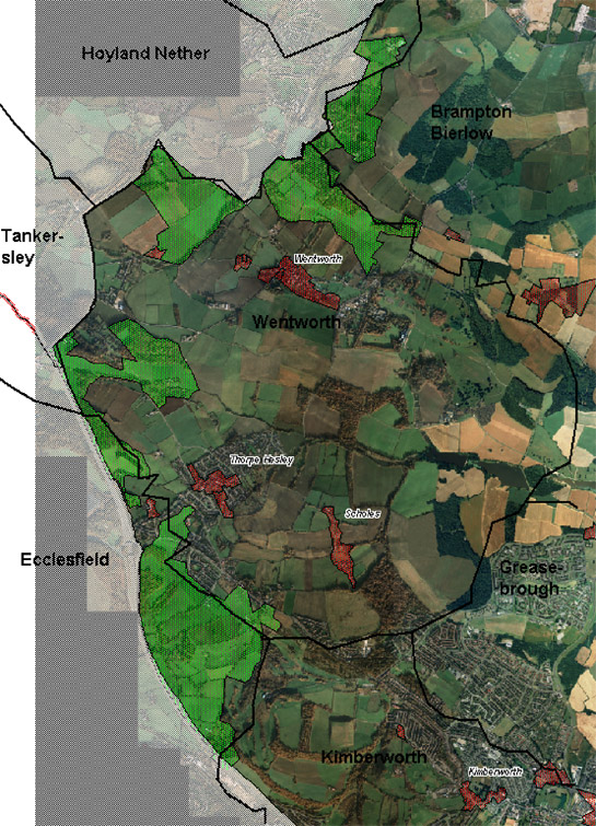
Figure 1: The ‘Assarted Enclosure Zone’ (green) typically occupies parish edge locations (black lines) at a distance from medieval nucleated settlements (red), which tend to be surrounded by former open field landscapes.
Cities Revealed aerial photography © the GeoInformation Group, 1999.
The zone lies adjacent to two large character areas within the ‘Private Parkland’ zone - at Wentworth Woodhouse and Kimberworth. Similar relationships can be seen in Barnsley’s Assarted Enclosure zone and has been remarked on elsewhere in the country. This relationship may in part be due to the former wooded character of the land here, as a link has been made between heavily wooded regions and high numbers of deer parks (Rackham 1986, 123).
Inherited Character
Landscapes resulting from piecemeal woodland clearance are generally considered more likely to contain botanically rich hedgerows (Taylor 1975, 95) and examples of mature irregular hedgerows can be seen in most of the character areas within this zone.
Remnants of the ancient woodlands from which much of this enclosed landscape was assarted can be seen across this zone. These larger areas of woodland typically survive on steep slopes where land has been impractical to clear for agriculture. The survival of ancient woodland on marginal land is also evident when the woodland distribution is compared with historic parish boundaries; many of the surviving woodlands are on the edge of the parish, sometimes straddling parish boundaries.
Woodland was an important resource in the medieval and later periods. It was, of course, the chief source of timber, which was the major building material until the 17th century transition to stone (Hey 1979, 131). Woods and wooded pastures were also utilised for fuel production and as grazing land from the medieval period onwards (Rackham 1986, 89,121). The driving force for the expansion of enclosure into wooded areas may have been increases in population in the early medieval period (Hey 1979, 72). This would explain the ‘parish edge’ location so characteristic of these landscapes.
Although little or no methodological archaeological survey has taken place in the ancient woodlands of this zone, where other ancient woodlands in Rotherham have been surveyed in detail (Cumberpatch 2001; Lee and Richardson 2003; Lee 2005) they have been shown to preserve a wide variety of earthworks of prehistoric to modern date. Only two records are currently held on the South Yorkshire SMR for monuments within this zone, both within King’s Wood. One records a surviving earthwork along a historic parish boundary (SMR ref: 1127), the other, an 18th century colliery air shaft (SMR ref: 2851). However, historic mapping and the evidence from other woodlands suggests that further unrecorded archaeological features are highly likely. Clear evidence can be seen, for example, in recent LIDAR survey data for the survival of the annular spoil heaps often associated with ‘bell pit’ mining techniques within woodlands adjacent to the M1 motorway.
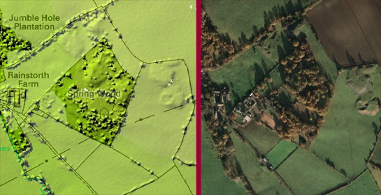
Figure 2: LIDAR Survey has the potential to reveal earthworks (such as these probable annular spoil heaps within Spring Wood) that are poorly visible on vertical aerial photographs.
LIDAR survey image [left] © Environment Agency, 2006 - Cities Revealed aerial photography [right] © the Geoinformation Group, 1999.
As the above images show, the earthworks produced by bell pit mining are also visible in enclosed landscapes outside woodland areas. In South Yorkshire the latest known examples of these monuments, which generally relate to the extraction of iron ore, date to the mid 19th century and include the large planned groups at Tankersley Park (Jones 1995, 99) and Hood Hill (SMR ref: 3511), which are likely to have been associated with the systematic exploitation of iron ore reserves on the Fitzwilliam Estate. However, ironstone mining in South Yorkshire is known to have been exploited as early as the 12th century - by Cistercian monks from Kirkstead Abbey in Lincolnshire, at Thundercliffe Grange (Munford 2000, 48). Surviving mining earthworks in this zone, therefore, have the potential to range in date from the 12th to the 19th centuries.
Later Characteristics
As with agricultural enclosed landscapes throughout South Yorkshire, the most dramatic landscape trend has been the removal of field boundaries to produce progressively larger units of production and the increasing mechanisation of cultivation techniques. These processes tend towards the homogenisation of the landscape. Over 50% of the land (and the bulk of the enclosed land) within this zone has been recorded by the characterisation project as ‘Agglomerated Fields’, due to the level of boundary loss. The most rapid period of change is recorded as being within the range 1945–1982.
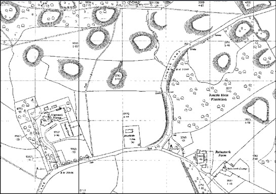
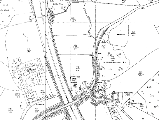
Figure 3: These extracts of 1:2500 OS mapping were published in 1965 (above) and 1970 (below) and show the rapid landscape change around the time of construction of the M1 motorway. All traces of spoil heaps in this area have been ploughed flat; some fields have been truncated and rationalised; Jumble Hole plantation has largely been felled.
© and database right Crown Copyright and Landmark Information Group Ltd (All rights reserved 2008) Licence numbers 000394 and TP0024.
Agglomeration has gone hand in hand with the introduction of new cultivation practices, in some parts of this zone including the introduction of arable cultivation into previously pastoral areas, which has had a dramatic impact on the survival of earthwork features such as mining spoil heaps. The most dramatic later 20th century change within this landscape has been the construction of the M1 motorway in the later 1960s. This road, which now forms the western edge of the ‘Hesley Wood and Barley Hole Countryside’ and ‘Thorpe Hesley Countryside’ character areas, truncates earlier landscape features and has redefined the boundary between the historic administrative units of Ecclesfield on the Sheffield side of the road and Kimberworth and Wentworth on the Rotherham side.
Character Areas within this Zone
Map links will open in a new window.
- Hesley Wood and Barley Hole Countryside (Map)
- Kings Wood and Simon Wood (Map)
- Low Harley Countryside (Map)
- Thorpe Hesley Countryside (Map)
Bibliography
- Cumberpatch, C.
- 2001 An Archaeological desktop study of four areas of woodland in Rotherham [unpublished]. Sheffield: CG Cumberpatch BA PhD Archaeological Consultant.
- Kain, R.J.P. and Oliver, R.R.
- 2001 Historic Parishes of England and Wales: an Electronic Map of Boundaries before 1850 with a Gazetteer and Metadata [computer file]. Colchester, Essex: History Data Service, UK Data Archive [distributor], 17 May 2001. SN: 4348.
- Lee, D. and Richardson, J.
- 2003 Grange Park Woods, Treeton Wood and Wath and Boyd Royd Wood, Rotherham, South Yorkshire [unpublished]. Morley: ASWYAS.
- Lee, D.
- 2003 Grange Park Woods, Canklow Wood and Treeton Wood, Rotherham, South Yorkshire [unpublished]. Morley: ASWYAS.
- Munford, A.P.
- 2000 A History of Rotherham. Stroud: Sutton Publishing
- Rackham, O.
- 1986 The History of the Countryside. London: J.M. Dent.
- SYAS
- 2008 South Yorkshire Sites and Monument Record [dynamic MS Access – GIS database] Sheffield: South Yorkshire Archaeology Service. Available by appointment with SYAS, Howden House, 1 Union Street, Sheffield, S1 2SH. Email: syorks.archservice@sheffield.gov.uk [accessed 26/02/08].
- Taylor, C.
- 1975 Fields in the English Landscape. London: Dent.