Grid Iron Terraced Housing
Summary of Dominant Character
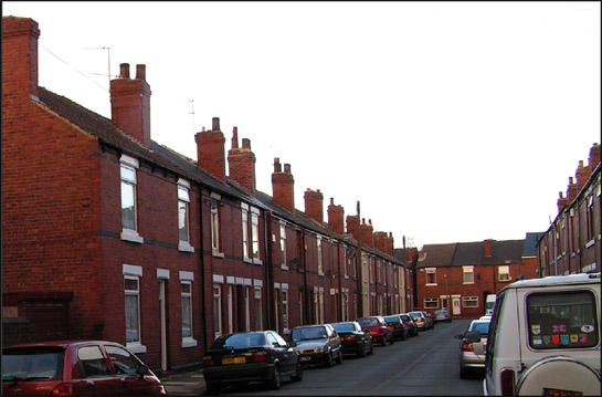
Figure 1: Terraced housing on Gladys Street, in the ‘Clifton Park Terraces’ character area.
© 2005 SYAS
The housing patterns of this zone are characterised by regular grid patterns of streets with conjoined two storey red-brick housing, which developed from the late 19th century to the 1930s. There is generally much similarity of building styles within rows of terraces, each house exhibiting a repeated design, but within the zone there is a certain amount of variation. Rear access to rows of houses is a typical example of variation. Such access was necessary in the 19th and early 20th century for the emptying of toilets and could be facilitated in a number of ways, including: shared yards running off the main street; back alleys running the length of streets; and covered passageways running through the terrace to a rear yard or alley. Sheffield has a dominant tradition of passageway access through terraces, a pattern that has been explained as a continuation of an older practice of constructing domestic ‘courts’ of back-to-back houses (Muthesius 1982). This is in contrast to Doncaster, which has mainly alleyway access. The ‘Grid Iron Terraced Housing’ zones within Barnsley and Rotherham, however, exhibit a mixture of these traditions. In Rotherham access via passageways through the houses is the dominant form of rear access, but rear alleyway access is more common where larger houses were built with integral toilet facilities.
Many areas of housing within this zone contain contemporary institutional buildings, especially churches and schools, although these have often been reused. These suburbs were also provided with shops and pubs (often on street corners) and land set aside for allotment gardens.
Rotherham’s rapid industrial growth during the later 18th and 19th centuries produced acute housing need within the town centre, as it did across the country wherever agrarian and industrial revolutions led to the migration of labourers to nearby urban centres. Much of this new industrial population was initially housed in high density conjoined row housing, typically built in short rows or ranges around a small courtyard, erected at a low cost within existing urban plots. The earliest terraced housing within larger urban centres followed these building styles and often included back-to-back houses. Few of these earliest phases of terraced housing survive within Rotherham, as they were demolished in various phases of slum clearance in the 20th century.
From the 1840s there were increasing concerns over the standard of housing for the poorer parts of society (Havinden 1981, 417) and the beginnings of pressure for local authorities to intervene in matters of housing. In Rotherham, industrial growth and demographic shifts in population and living patterns had greatly increased the density of the historic core of the town by the mid 19th century; most of the historic burgages had been intensified over the previous century by the construction of courts of small insanitary cottages within their back-lands by private landlords. This unregulated urban growth, in a town that could claim no real sewerage system, accompanied by large numbers of livestock within the town, was widely believed to have exacerbated the woeful mortality rates revealed by the enquiry into the condition of the town undertaken pursuant to the 1850 Public Health Act, with one in 6 children dying before their first birthday (Munford 1995, 276).
The continuing interest in the living conditions of the working classes led to a further Public Health Act in 1875 - notable in the giving of powers to ‘sanitary authorities’ to make by-laws to control building standards and designs (Newman 2001, 99). These by-laws tended to encourage standardised housing developments, designed to meet minimum requirements for road widths, building heights and drainage provisions – helping to produce the fairly uniform character of streets within this zone.
Relationship to Adjacent Character Zones
Within the district of Rotherham, 309 hectares of terraced housing have been recorded by the characterisation project, but only 1/3 of this area is included within the ‘Grid Iron Terraced Housing’ zone. Most of the remaining terraces are found within the ‘Industrial Settlements’ zone. These settlements developed from the tradition of colliery rows and there is often little clear structure to their layout, with regular grids less apparent than within this zone. Within the ‘Industrial Settlement’ zone the style of terraced housing is also more likely to be varied.
As is typical across many parts of Britain industrialised in the later 19th century, the development of large areas of terraced housing in Rotherham is closely related to contemporary industries and the need to quickly and affordably house workers and their families. Each area of this zone is adjacent to sites of significant industrial employment in the late 19th and early 20th century, particularly the heavy metal trades to be found in the Don and Rother valleys at Eastwood, Masborough and Ickles.
In the ‘Clifton Park Terraces’ character area there tend to be more larger houses included and more trees lining the streets than in other parts of the zone. These areas of terraced housing are slightly further from the 19th and early 20th century industries and have characteristics in common with the grander ‘19th to early 20th Century Villa Suburbs’ that they adjoin. Freehold land societies are likely to have been involved in the early stages of the development of these areas, a pattern that has also been observed in the Grid Iron Terraced zones of Barnsley and Sheffield (see ‘19th to early 20th Century Villa Suburbs’ zone).
Large areas of early terraced housing were knocked down in the 1960s and 70s within the area now occupied by the ‘Late 20th Century Replanned Centres’ character zone. This area, built to a strict street grid, represented the bulk of the ‘bylaw’ type terraced housing built in the town before 1891.
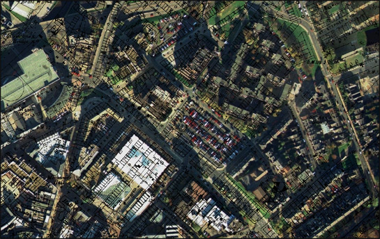
Figure 2: The area occupied by Rotherham Markets, the Arts Centre and the Civic Building was cleared of grid iron terraced housing in the late 1960s.
Aerial photography © the GeoInformation Group, 1999; 1891 OS 25 inch to the mile data ? and database right Crown Copyright and Landmark Information Group Ltd (All rights reserved 2008) Licence numbers 000394 and TP0024.
On the whole, development within this zone did not preserve earlier field boundary patterns. There are some places where indications survive of earlier villa developments, which have seen subsequent intensification. Examples of this process are most common in the ‘Clifton Park Terraces’ character area. This area surrounds post-medieval ribbon development along Westgate and appears to have been a focus for the construction of lower middle class housing during the late 19th century, with partially developed streets visible by 1891 at Clifton Bank, Wellgate Mount, Aldred Street, Chatham Street and Clifton Lane. These developments largely fossilised the boundary patterns indicated on a 1764 map of the area (Kelk 1764), a mixture of sinuous piecemeal and straighter parliamentary enclosures. This type of development pattern, where land is first divided into plots that are subsequently developed in turn by individually designed properties before amalgamation and development as terraces, has been noted in Barnsley and Sheffield as well as elsewhere in Rotherham and is thought to be typical of ‘Freehold Land’ societies.
These societies provided an important impetus to the development of 19th century suburbs. Once established, a society bought up whole estates and divided them into individual plots, members of the society paying a monthly contribution to costs and charges for making roads with the society being wound up once costs for the land had been met. These types of land society were popular because they enabled larger numbers of people to vote, as voting rights were linked to property ownership (Harman and Minnis 2004, 282).
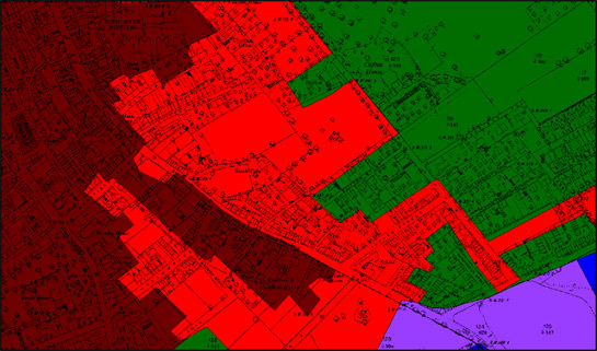
Figure 3: The ‘Clifton Terraces’ character area (red) in 1891, surrounded by the historic core (brown) and 19th Century Villa suburbs (green). The area was later infilled with grid iron terraced developments.
Map base © and database right Crown Copyright and Landmark Information Group Ltd (All rights reserved 2008) Licence numbers 000394 and TP0024
Later Characteristics
Wholesale 20th century changes to this character zone are limited, with housing clearance by and large restricted to areas of older housing in other zones. However, social change over the past one hundred years has led to significant changes to the way these houses are occupied and maintained. Most notably, the now widespread phenomenon of multiple car ownership has had a significant affect of the streetscape of these areas, with off-road opportunities for parking near completely absent and on road opportunities limited by the inherent short street frontage of each property. Within properties the most notable change has probably been the introduction of bathrooms and toilets within the main living accommodation, rather than contained within the back yard. Changes in property maintenance impacting on the general character of the area include the widespread replacement of wooden doors and windows with double glazed uPVC units; the replacement of welsh slate roofing with concrete and other composite materials; and the introduction of TV and satellite aerials.
Changes in attitudes and practices concerning religion and schooling are also manifesting themselves in the changing characteristics of former institutional buildings in this zone, with the buildings generally provided for these purposes now often put to re-use as community centres, clubs or youth centres.
Character Areas within this Zone
Map links will open in a new window.
- Brinsworth Terraces (Map)
- Clifton Park Terraces (Map)
- Eastwood Terraces (Map)
- Kimberworth Terraces (Map)
- Masborough/ Holmes Terraces (Map)
- Masborough Thorn Hill Terraces (Map)
Bibliography
- Havinden, M.
- 1981 The Model Village. In: G.E. Mingay (ed.), The Victorian Countryside, Volume II. London and Boston: Routledge & Kegan Paul, 414-427.
- Kelk, G.
- 1764 A Map of the Manor of Rotherham.
- Munford, A.
- 1995 From Slums to Council Houses: The Rotherham Experience. In: M. Jones (ed.), Aspects of Rotherham. Barnsley: Wharncliffe Books, 273-297.
- Muthesius, S.
- 1982 The English Terraced House. New Haven: Yale University Press.
- Newman, R., Cranstone, D. and Howard-Davis, C.
- 2001 The Historical Archaeology of Britain c1540-1900. Stroud: Sutton Publishing.